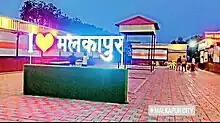
Malkapur
New Malkapur | |
|---|---|
City | |
| Malkapur City | |
 Malkapur | |
| Coordinates: 20°53′06″N 76°12′00″E / 20.885°N 76.2°E | |
| Country | |
| State | Maharashtra |
| District | Buldhana |
| Area | |
| • Total | 50.80 km2 (19.61 sq mi) |
| Elevation | 255 m (837 ft) |
| Population (2021)[1] | |
| • Total | 167,740 |
| • Density | 280/km2 (700/sq mi) |
| Language | |
| • Official | Marathi |
| Time zone | UTC+5:30 (IST) |
| PIN | 443101 |
| Telephone code | 07267 |
| Vehicle registration | MH 28 |
| Sex ratio | 0.9333 ♂/♀ |
| Literacy | 85% |
Malkapur is a historical city and municipality in the Buldhana district of Maharashtra, India. Malkapur is one of the largest cotton producers in the area. In the British era, it was known as the "White gold of Vidarbha". Malkapur has a vast paper industry and the primary paper suppliers to Mumbai are in Malkapur. Malkapur has many Dal mills, and a major agricultural industry specializing in Mahyco and Ankur seeds, chemical plants, and a fruit ripening chamber. Malkapur is a well-known grain and cloth market due to its proximity to Madhya Pradesh. It is one of the major producers of red chili.
History
One of the old gates of the rampart of dressed stones had an inscription to the effect that it was erected in 1729 during the reign of Muhammad Malikkhan. Malkapur is mentioned in Ain-i-Akbari as the headquarters of a paragana in the sarkar of Narnala. The town is said to have been founded about five centuries back by a prince of the Faruqi house of Khandesh and is said to have been named by him after the princess, Malika, his daughter. But the story is improbable as no record of any journey in this direction by Miran Ghani Adil Khan, the Faruqi prince of the period has yet been traced. In 1761 the town was rich enough to pay Rs. 60,000 to the army of Raghunath Rav for exemption from plunder. The Nizams used to keep a force of about 20,000 men in this frontier district of their dominions. Daulatrav Shinde and Raghuji Bhosle were encamped near Malkapur when the British envoy Colonel Collins, after presenting General Wellesley's ultimatum, quitted Shinde's camp in 1803.[2]
Malkapur was the scene of several petty battles between zamin-dars, rural talukdars, Rajputs and Musalmans. Notable families among these are The Raje Nemiwants, the talukdar appointed by Nizam, currently settled in Hyderabad, represented by Shri. Raje Laxmanrao Nemiwant, and The titular Rana Sarpatil Sarkar & Deshmukh Zamindar, previously a sardar family of Maharaja Bhosale Nagpur, currently settled in Talode, Maharashtra, represented by Raosaheb Dr. Onkar Singhji Rajput. This was during the period between the beginning of the nineteenth century and the Assignment of Berar to the East India Company in 1853.
Demographics
According to the 2011 census,[3] Malkapur Municipal Council has a population of 67,740. In which 34,693 are males and 33,047 females . Malkapur has an average literacy rate of 82%, higher than the national average of 75%. The male literacy is 89% and female literacy is 75%. In Malkapur, 20% of the population is under 6 years of age.
| Year | Male | Female | Total Population | Change | Religion (%) | |||||||
|---|---|---|---|---|---|---|---|---|---|---|---|---|
| Hindu | Muslim | Christian | Sikhs | Buddhist | Jain | Other religions and persuasions | Religion not stated | |||||
| 2001[4] | 31398 | 29614 | 61012 | - | 51.393 | 41.739 | 0.113 | 0.098 | 4.183 | 2.460 | 0.013 | 0.000 |
| 2011[5] | 34693 | 33047 | 67740 | 0.110 | 46.826 | 45.638 | 0.145 | 0.035 | 4.519 | 2.325 | 0.012 | 0.500 |
Transport
Malkapur is located on the Hajira - Kolkata National Highway 6, which is a part of the Asian Highway 46 from Kharagpur to Dhule.Malkapur railway station lies on the Howrah-Nagpur-Mumbai line.[6] Malkapur bus station is on Buldhana road. A boat facility is also available at Nalganga river.
References
- ↑ "Village/Town-wise Primary Census Abstract, 2011 - MAHARASHTRA". 13 January 2015.
- ↑ {{cite web|url=https://cultural.maharashtra.gov.in/english/gazetteer/BULDHANA/places_Malkapur.html
- ↑ "Village/Town-wise Primary Census Abstract, 2011 - MAHARASHTRA". 13 January 2015.
- ↑ Census India 2001.
- ↑ Census India 2011.
- ↑ Running, Train. "MKU/Malkapur railway station". train running status. Retrieved 22 June 2017.
.svg.png.webp)