Manternach
Manternach | |
|---|---|
 | |
 Coat of arms | |
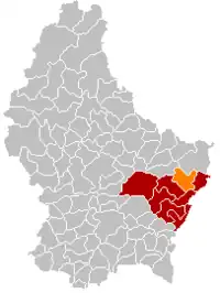 Map of Luxembourg with Manternach highlighted in orange, and the canton in dark red | |
| Coordinates: 49°42′25″N 6°25′25″E / 49.7069°N 6.4236°E | |
| Country | |
| Canton | Grevenmacher |
| Area | |
| • Total | 27.68 km2 (10.69 sq mi) |
| • Rank | 30th of 102 |
| Highest elevation | 341 m (1,119 ft) |
| • Rank | 87th of 102 |
| Lowest elevation | 181 m (594 ft) |
| • Rank | 17th of 102 |
| Population (2023) | |
| • Total | 2,298 |
| • Rank | 69th of 102 |
| • Density | 83/km2 (220/sq mi) |
| • Rank | 77th of 102 |
| Time zone | UTC+1 (CET) |
| • Summer (DST) | UTC+2 (CEST) |
| LAU 2 | LU0001106 |
| Website | manternach.lu |
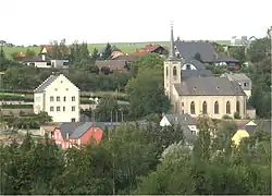
Manternach is a commune and small town in eastern Luxembourg. It is part of the canton of Grevenmacher.
As of 2001, the town of Manternach, which lies in the south of the commune, has a population of 417. Other towns within the commune include Berbourg, Lellig, and Munschecker.
Manternach railway station has regular services directly to Luxembourg railway station in Luxembourg city and Wasserbillig.There are normally 35 trains per day travelling from Manternach to Luxembourg[1]
Population
Image gallery
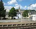 Manternach, seen from the railway station
References
- ↑ "Manternach to Luxembourg by Train | Cheap Tickets & Times". Trainline. Retrieved 2021-09-14.
- ↑ "Population par canton et commune". statistiques.public.lu. Retrieved 11 January 2022.
External links
 Media related to Manternach at Wikimedia Commons
Places adjacent to Manternach | ||||||||||||||||
|---|---|---|---|---|---|---|---|---|---|---|---|---|---|---|---|---|
| ||||||||||||||||
 | ||
This article is issued from Wikipedia. The text is licensed under Creative Commons - Attribution - Sharealike. Additional terms may apply for the media files.