Maropaika | |
|---|---|
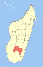
 Maropaika Location in Madagascar | |
| Coordinates: 22°42′S 46°59′E / 22.700°S 46.983°E | |
| Country | Madagascar |
| Region | Ihorombe |
| District | Ivohibe |
| Elevation | 603 m (1,978 ft) |
| Population (2001)[2] | |
| • Total | 9,000 |
| Time zone | UTC3 (EAT) |
Maropaika is a town and commune in Madagascar. It belongs to the district of Ivohibe, which is a part of Ihorombe Region. The population of the commune was estimated to be approximately 9,000 in 2001 commune census.[2]
Maropaika has a riverine harbour. Primary and junior level secondary education are available in town. The majority 56% of the population of the commune are farmers, while an additional 40% receive their livelihood from raising livestock. The most important crop is rice; other important products are peanuts, beans, and cassava. Services provide employment for 1% of the population. Additionally, fishing employs 3% of the population.[2]
It is connected with Ihosy in the west, and Farafangana in the east by the largely unpaved Route nationale 27.
References and notes
- ↑ Estimated based on DEM data from Shuttle Radar Topography Mission
- 1 2 3 "ILO census data". Cornell University. 2002. Retrieved 1 May 2008.
22°42′S 46°59′E / 22.700°S 46.983°E