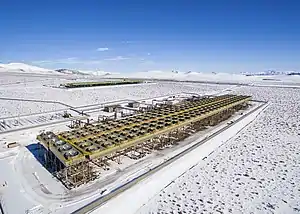
| McGinness Hills Geothermal Complex | |
|---|---|
 | |
| Official name | McGinness Hills Geothermal Complex |
| Country | United States |
| Location | Lander County, Nevada |
| Coordinates | 39°35′21″N 116°54′42″W / 39.58917°N 116.91167°W |
| Status | Operational |
| Commission date | Unit 1: July 2012 Unit 2: July 2012 Unit 3: 20 December 2018 |
| Owner(s) | Ormat |
| Operator(s) | Ormat |
| Geothermal power station | |
| Type | Binary cycle[1] |
| Power generation | |
| Units operational | 2 x 45 MW 1 x 48 MW |
| Nameplate capacity | 138 MW[2][3] |
| Annual net output | 771 GWh (2018) [4][5] |
| External links | |
| Commons | Related media on Commons |
The McGinness Hills Geothermal Complex is a complex of 3 geothermal power stations located in a valley between the Toiyabe Range and Simpson Park Range in Lander County, Nevada. It is the largest geothermal complex in Nevada and the fourth largest in the United States.
The complex consists of two 45 MW geothermal power stations that were commissioned in July 2012, as well as a third 48 MW geothermal power station that was commissioned on 20 December 2018.[2] The entire complex is owned by Ormat.[3]
See also
References
Wikimedia Commons has media related to McGinness Hills Geothermal Complex.
- ↑ Nordquist, Josh; Delwiche, Ben (2013). "the McGinness Hills Geothermal Project" (PDF). geothermal-library.org. Retrieved February 7, 2020.
- 1 2 Richter, Alexander (December 20, 2018). "48 MW McGinness Hills Phase 3 geothermal plant starts operation in Nevada". ThinkGeoEnergy. Retrieved February 6, 2020.
- 1 2 "Ormat Technologies Inc. - Ormat Technologies Inc. - Global Projects". www.ormat.com. Retrieved February 5, 2020.
- ↑ "Electricity Data Browser - McGinness Hills". www.eia.gov. Retrieved February 6, 2020.
- ↑ "Electricity Data Browser - McGinness Hills 3". www.eia.gov. Retrieved February 6, 2020.
This article is issued from Wikipedia. The text is licensed under Creative Commons - Attribution - Sharealike. Additional terms may apply for the media files.