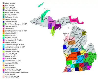
Map of the 33 core-based statistical areas in Michigan.
An enlargeable map of the 33 core-based statistical areas in Michigan.[1]

The U.S. State of Michigan currently has 40 statistical areas that have been delineated by the Office of Management and Budget (OMB). On March 6, 2020, the OMB delineated seven combined statistical areas, 15 metropolitan statistical areas, and 18 micropolitan statistical areas in Michigan.[1]

Statistical areas

The U.S. Office of Management and Budget (OMB) has designated more than 1,000 statistical areas for the United States and Puerto Rico.[2] These statistical areas are important geographic delineations of population clusters used by the OMB, the United States Census Bureau, planning organizations, and federal, state, and local government entities.

The OMB defines a core-based statistical area (commonly referred to as a CBSA) as "a statistical geographic entity consisting of the county or counties (or county-equivalents) associated with at least one core[lower-alpha 1] of at least 10,000 population, plus adjacent counties having a high degree of social and economic integration with the core as measured through commuting ties with the counties containing the core."[2] The OMB further divides core-based statistical areas into metropolitan statistical areas (MSAs) that have "a population of at least 50,000" and micropolitan statistical areas (μSAs) that have "a population of at least 10,000, but less than 50,000."[2]

The OMB defines a combined statistical area (CSA) as "a geographic entity consisting of two or more adjacent core-based statistical areas with employment interchange measures[lower-alpha 2] of at least 15%."[2] The primary statistical areas (PSAs) include all combined statistical areas and any core-based statistical area that is not a constituent of a combined statistical area.

Table

The table below describes the 40 United States statistical areas and 83 counties of the State of Michigan with the following information:[3]

  1. The combined statistical area (CSA) as designated by the OMB.[1]
  2. The CSA population according to 2019 US Census Bureau population estimates.[4]
  3. The core based statistical area (CBSA)[2] as designated by the OMB.[1]
  4. The CBSA population according to 2019 US Census Bureau population estimates [4]
  5. The county name
  6. The county population according to 2019 US Census Bureau population estimates [4]
  7. The Metropolitan Division name, if applicable[1]
  8. The Metropolitan Division population according to 2019 US Census Bureau population estimates [4]
The 40 United States statistical areas and 83 counties of the State of Michigan

Combined statistical area 2019 population Core based statistical area 2019 population County 2019 population Metropolitan division 2019 population
Detroit-Warren-Ann Arbor, MI CSA 5,341,994 Detroit-Warren-Dearborn, MI MSA 4,319,629 Oakland County, Michigan 1,257,584 Warren-Troy-Farmington Hills, MI MD 2,570,286
Macomb County, Michigan 873,972
Livingston County, Michigan 191,995
St. Clair County, Michigan 159,128
Lapeer County, Michigan 87,607
Wayne County, Michigan 1,749,343 Detroit-Dearborn-Livonia, MI MD 1,749,343
Flint, MI MSA 405,813 Genesee County, Michigan 405,813 none
Ann Arbor, MI MSA 367,601 Washtenaw County, Michigan 367,601
Monroe, MI MSA 150,500 Monroe County, Michigan 150,500
Adrian, MI μSA 98,451 Lenawee County, Michigan 98,451
Grand Rapids-Kentwood-Muskegon, MI CSA 1,412,470 Grand Rapids-Kentwood, MI MSA 1,077,370 Kent County, Michigan 656,955
Ottawa County, Michigan 291,830
Ionia County, Michigan 64,697
Montcalm County, Michigan 63,888
Muskegon, MI MSA 173,566 Muskegon County, Michigan 173,566
Holland, MI μSA 118,081 Allegan County, Michigan 118,081
Big Rapids, MI μSA 43,453 Mecosta County, Michigan 43,453
none Lansing-East Lansing, MI MSA 550,391 Ingham County, Michigan 292,406
Eaton County, Michigan 110,268
Clinton County, Michigan 79,595
Shiawassee County, Michigan 68,122
Kalamazoo-Battle Creek-Portage, MI CSA 503,706 Kalamazoo-Portage, MI MSA 265,066 Kalamazoo County, Michigan 265,066
Battle Creek, MI MSA 134,159 Calhoun County, Michigan 134,159
Sturgis, MI μSA 60,964 St. Joseph County, Michigan 60,964
Coldwater, MI μSA 43,517 Branch County, Michigan 43,517
Saginaw-Midland-Bay City, MI CSA 376,821 Saginaw, MI MSA 190,539 Saginaw County, Michigan 190,539
Bay City, MI MSA 103,126 Bay County, Michigan 103,126
Midland, MI MSA 83,156 Midland County, Michigan 83,156
South Bend-Elkhart-Mishawaka, IN-MI CSA 809,069
205,188
South Bend-Mishawaka, IN-MI MSA 323,613
51,787
St. Joseph County, Indiana 271,826
Cass County, Michigan 51,787
Elkhart-Goshen, IN MSA 206,341 Elkhart County, Indiana 206,341
Niles, MI MSA 153,401 Berrien County, Michigan 153,401
Warsaw, IN μSA 79,456 Kosciusko County, Indiana 79,456
Plymouth, IN μSA 46,258 Marshall County, Indiana 46,258
none Jackson, MI MSA 158,510 Jackson County, Michigan 158,510
Traverse City, MI μSA 150,653 Grand Traverse County, Michigan 93,088
Leelanau County, Michigan 21,761
Kalkaska County, Michigan 18,038
Benzie County, Michigan 17,766
Mount Pleasant-Alma, MI CSA 110,583 Mount Pleasant, MI μSA 69,872 Isabella County, Michigan 69,872
Alma, MI μSA 40,711 Gratiot County, Michigan 40,711
none Marquette, MI μSA 66,699 Marquette County, Michigan 66,699
Cadillac, MI μSA 48,749 Wexford County, Michigan 33,631
Missaukee County, Michigan 15,118
Marinette-Iron Mountain, WI-MI CSA 92,664
48,019
Marinette, WI-MI μSA 63,130
22,780
Marinette County, Wisconsin 40,350
Menominee County, Michigan 22,780
Iron Mountain, MI-WI μSA 29,534
25,239
Dickinson County, Michigan 25,239
Florence County, Wisconsin 4,295
none Hillsdale, MI μSA 45,605 Hillsdale County, Michigan 45,605
Houghton, MI μSA 37,800 Houghton County, Michigan 35,684
Keweenaw County, Michigan 2,116
Sault Ste. Marie, MI μSA 37,349 Chippewa County, Michigan 37,349
Escanaba, MI μSA 35,784 Delta County, Michigan 35,784
Ludington, MI μSA 29,144 Mason County, Michigan 29,144
Alpena, MI μSA 28,405 Alpena County, Michigan 28,405
none Van Buren County, Michigan 75,677
Barry County, Michigan 61,550
Tuscola County, Michigan 52,245
Newaygo County, Michigan 48,980
Sanilac County, Michigan 41,170
Emmet County, Michigan 33,415
Huron County, Michigan 30,981
Clare County, Michigan 30,950
Oceana County, Michigan 26,467
Charlevoix County, Michigan 26,143
Gladwin County, Michigan 25,449
Cheboygan County, Michigan 25,276
Iosco County, Michigan 25,127
Otsego County, Michigan 24,668
Manistee County, Michigan 24,558
Roscommon County, Michigan 24,019
Osceola County, Michigan 23,460
Antrim County, Michigan 23,324
Ogemaw County, Michigan 20,997
Arenac County, Michigan 14,883
Crawford County, Michigan 14,029
Gogebic County, Michigan 13,975
Presque Isle County, Michigan 12,592
Lake County, Michigan 11,853
Iron County, Michigan 11,066
Mackinac County, Michigan 10,799
Alcona County, Michigan 10,405
Montmorency County, Michigan 9,328
Alger County, Michigan 9,108
Oscoda County, Michigan 8,241
Baraga County, Michigan 8,209
Schoolcraft County, Michigan 8,094
Luce County, Michigan 6,229
Ontonagon County, Michigan 5,720
State of Michigan 9,986,857

See also

Notes

  1. The OMB defines a core as "a densely settled concentration of population, comprising an Urban Area (of 10,000 or more population) delineated by the Census Bureau, around which a core-based statistical area is delineated."[2]
  2. The OMB defines the employment interchange measure as "the sum of the percentage of workers living in the smaller entity who work in the larger entity plus the percentage of employment in the smaller entity that is accounted for by workers who reside in the larger entity."[2]

References

  1. 1 2 3 4 5 Revised Delineations of Metropolitan Statistical Areas, Micropolitan Statistical Areas, and Combined Statistical Areas, and Guidance on Uses of the Delineations of These Areas (March 6, 2020). "0MB BULLETIN NO. 20-01" (PDF). Office of Management and Budget. Retrieved December 13, 2021.{{cite web}}: CS1 maint: multiple names: authors list (link)
  2. 1 2 3 4 5 6 7 "2020 Standards for Delineating Core Based Statistical Areas". Office of Management and Budget. July 16, 2021. Retrieved December 13, 2021.
  3. An out-of-state area and its population are displayed in green. An area that extends into more than one state is displayed in teal. A teal population number over a black population number show the total population versus the in-state population.
  4. 1 2 3 4 "Annual Estimates of the Resident Population for Counties in the United States: April 1, 2010 to July 1, 2019". United States Census Bureau, Population Division. April 2020. Retrieved April 9, 2020.

44°20′48″N 85°24′37″W / 44.3467°N 85.4102°W / 44.3467; -85.4102 (State of Michigan)

This article is issued from Wikipedia. The text is licensed under Creative Commons - Attribution - Sharealike. Additional terms may apply for the media files.