Middle Third
An Trian Meánach (Irish) | |
|---|---|
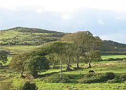 Middle Third countryside, Ballyscanlon | |
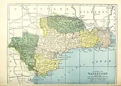 Barony map of County Waterford, 1900; Middle Third is coloured yellow, in the east. | |
| Sovereign state | Ireland |
| Province | Munster |
| County | Waterford |
| Area | |
| • Total | 180.53 km2 (69.70 sq mi) |
Middle Third or Middlethird (Irish: An Trian Meánach[1]) is a barony in County Waterford, Ireland.[2]
Etymology
A "third" (trian) was an old Irish land division of variable extent. The other "thirds" were Upperthird and Gaultier.[3]
Geography
Middle Third is located in the east of County Waterford, south of the River Suir and west of Gaultier. It contains the stretch of coastline from Tramore Bay to Dunabrattin Head.
It also contains Bilberry Rock, site of a feral goat herd for centuries.
History
Middle Third was a barony by 1672.
Some of Middle Third was anciently part of the Viscount Doneraile's estate.[4] The western part formed part of Paoracha, "Powers' Country."[5]
List of settlements
Below is a list of settlements in Middle Third barony:
References
- ↑ "An Trian Meánach/Middle Third". Logainm.ie.
- ↑ Carlisle, Nicholas (20 December 2018). "4A Topographical Dictionary of Ireland ... Being a Continuation of the Topography of the United Kingdom of Great Britain and Ireland". Miller – via Google Books.
- ↑ Power, Patrick (1907). The Place-names of Decies. D. Nutt – via Internet Archive.
variable extent.
- ↑ Doneraile, Viscounts (1759). "Halfe years rent roll of Kilmeaden Estate for the 25th March and first May, 1759, No. 4". catalogue.nli.ie.
- ↑ http://snap.waterfordcoco.ie/collections/ebooks/106325/106325.pdf
| ||
| ||
Places in County Waterford | ||
|---|---|---|
| Towns |  | |
| Villages and Townlands |
| |
| ||
This article is issued from Wikipedia. The text is licensed under Creative Commons - Attribution - Sharealike. Additional terms may apply for the media files.