Monroe | |
|---|---|
 Tippecanoe County's location in Indiana | |
 Monroe Location in Tippecanoe County | |
| Coordinates: 40°17′11″N 086°44′07″W / 40.28639°N 86.73528°W | |
| Country | United States |
| State | Indiana |
| County | Tippecanoe |
| Township | Lauramie |
| Elevation | 787 ft (240 m) |
| Time zone | UTC-5 (Eastern (EST)) |
| • Summer (DST) | UTC-4 (EDT) |
| ZIP code | 47905 |
| Area code | 765 |
| GNIS feature ID | 439339[1] |
Monroe is a small unincorporated community in Lauramie Township, Tippecanoe County, in the U.S. state of Indiana.[1] The community is part of the Lafayette, Indiana Metropolitan Statistical Area.
History
A post office was established under the name Huntersville[2] in 1836; it was renamed Monroe in 1840, and remained in operation until it was discontinued in 1853.[3]
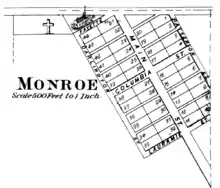
Monroe originally included three northwest/southeast streets (Darlington, Main, and Patterson) and three northeast/southwest streets (Fayette, Columbia, and Lauramie).[4]
Geography
Monroe sits in open farmland about 10 miles southeast of the city of Lafayette at the intersection of US Route 52 and County Road 900 South. Monroe Cemetery sits on the west side of town, and Lauramie Creek flows westward just to the south.
References
- 1 2 3 U.S. Geological Survey Geographic Names Information System: Monroe, Tippecanoe County, Indiana
- ↑ "USGS detail on Monroe - Variant Citation". Retrieved July 25, 2016.
- ↑ "Tippecanoe County". Jim Forte Postal History. Retrieved July 25, 2016.
- ↑ Kingman Brothers (1878). Combination Atlas Map of Tippecanoe County, Indiana. Lafayette, Indiana: Tippecanoe County Historical Society / Lafayette Printing Company. Retrieved March 30, 2018.
Municipalities and communities of Tippecanoe County, Indiana, United States | ||
|---|---|---|
| Cities | Map of Indiana highlighting Tippecanoe County | |
| Towns | ||
| Townships | ||
| CDPs | ||
| Other communities | ||
| Ghost towns | ||
| Footnotes | ‡This populated place also has portions in an adjacent county or counties | |