| Mount Norton | |
|---|---|
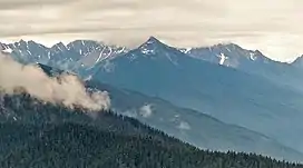 North aspect centered, from Hurricane Ridge. | |
| Highest point | |
| Elevation | 6,397 ft (1,950 m)[1] |
| Prominence | 599 ft (183 m)[2] |
| Parent peak | Crystal Peak (6,896 ft)[3] |
| Isolation | 3.11 mi (5.01 km)[3] |
| Coordinates | 47°45′45″N 123°24′50″W / 47.7625185°N 123.4137764°W[4] |
| Geography | |
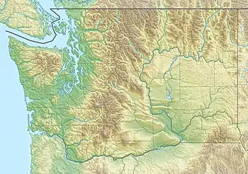 Mount Norton Location of Mount Norton in Washington  Mount Norton Mount Norton (the United States) | |
| Location | Olympic National Park Jefferson County, Washington, US |
| Parent range | Olympic Mountains |
| Topo map | USGS McCartney Peak |
| Geology | |
| Age of rock | Eocene |
| Climbing | |
| First ascent | 1947 |
| Easiest route | class 2 via Elwha River Trail[2] |
Mount Norton is a 6,397-foot-elevation (1,950-meter) mountain summit located in the Olympic Mountains in Jefferson County of Washington state. It is situated within Olympic National Park, and is set within the Daniel J. Evans Wilderness. Precipitation runoff from the mountain drains north via the Elwha River and Hayes River. Topographic relief is significant as the east aspect rises 3,200 feet (980 meters) above Hayes River in less than one mile, and the west aspect rises 4,400 feet (1,300 meters) above the Elwha valley in two miles. The lower slopes of the mountain are surrounded by forests of Western Red Cedar, Sitka Spruce, Western Hemlock, Alaskan Cedar, Mountain Hemlock, and Douglas-fir.
History
This landform was originally christened "Mount Egan" in 1890 by the 1889-90 Seattle Press Expedition, for John G. Egan (1857–1913), the editor of the Seattle Press newspaper which sponsored the expedition.[5] The mountain's present name is attributable to G.A. Whitehead of the U.S. Forest Service when he renamed the peak in 1925 for his friend and hunting partner, Ernest Norton.[6] The mountain's name has been officially adopted by the United States Board on Geographic Names.[4] Whitehead also named Mount Mystery and Mount Deception.
The first ascent of the summit was made in 1947 by Pat Cummins.[2]
Climate
Based on the Köppen climate classification, Mount Norton is located in the marine west coast climate zone of western North America.[7] Most weather fronts originate in the Pacific Ocean, and travel east toward the Olympic Mountains. As fronts approach, they are forced upward by the peaks of the Olympic Range, causing them to drop their moisture in the form of rain or snowfall (Orographic lift). As a result, the Olympics experience high precipitation, especially during the winter months. During winter months, weather is usually cloudy, but due to high pressure systems over the Pacific Ocean that intensify during summer months, there is often little or no cloud cover during the summer. The months June through August offer the most favorable weather for viewing or climbing this peak.[2]
See also
References
- ↑ Olympic Mountains: A Climbing Guide, Olympic Mountain Rescue, Fourth Edition, 2006, The Mountaineers Books, page 202.
- 1 2 3 4 Mount Norton, climbersguideolympics.com
- 1 2 "Norton, Mount - 6,319' WA". listsofjohn.com. Retrieved 2021-12-23.
- 1 2 "Mount Norton". Geographic Names Information System. United States Geological Survey, United States Department of the Interior. Retrieved 2022-02-16.
- ↑ Timothy Egan (2011), The Good Rain: Across Time & Terrain in the Pacific Northwest, Knopf Doubleday Publishing Group, ISBN 9780307794710, page 42.
- ↑ Parratt, Smitty (1984). Gods and Goblins: A Field Guide to Place Names of Olympic National Park (1st ed.).
- ↑ Peel, M. C.; Finlayson, B. L.; McMahon, T. A. (2007). "Updated world map of the Köppen−Geiger climate classification". Hydrol. Earth Syst. Sci. 11: 1633–1644. ISSN 1027-5606.
External links
- "Olympic National Park". National Park Service.
- Weather forecast: Mount Norton
Places adjacent to Mount Norton | |
|---|---|