| Mt. Shinobu | |
|---|---|
| 信夫山 | |
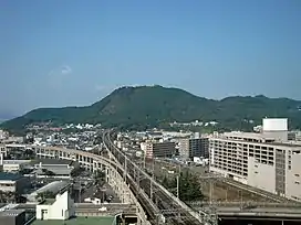
 Mt. Shinobu's southern side, as viewed from directly south of Fukushima Station, October 2008 | |
| Highest point | |
| Elevation | 275 m (902 ft)[1] |
| Coordinates | 37°46′33.7″N 140°28′27.5″E / 37.776028°N 140.474306°E[2] |
| Geography | |
Mt. Shinobu (信夫山, Shinobu-yama) is a 275-meter monadnock located in the center of Fukushima, Fukushima, Japan.
Geography
Mt. Shinobu rises 275 meters from the surrounding flat Fukushima Basin. The mountain has three main peaks: Mt. Ha (羽山, Ha-yama) is on the western part of the mountain and is the tallest peak at 275 meters, Mt. Haguro (羽黒山, Haguro-san) is in the center and tops out at 260 meters, and Mt. Kumano (熊野山, Kumano-san) is a 268-meter peak in the east. In addition to the three main peaks, there are also the smaller peaks of Mt. Tatsuishi (立石山, Tatsuishi-yama), which is north of Mt. Kumano and stands at 220 meters, and Tengunomori (天狗の森), which is a 183-meter peak on the southeast of the mountain.[3][4]
Mt. Shinobu is 2.7 km long from east to west, 1.4 km wide from south to north, and has a circumference of seven kilometers.[3]
Notes
- ↑ 信夫山 [Mt. Shinobu] (in Japanese). Yamaeki Online. Retrieved 4 July 2012.
- ↑ 地図閲覧サービス [Map Viewing Service] (in Japanese). Geospatial Information Authority of Japan. Retrieved 4 July 2012.
- 1 2 信夫山ドットコム [Shinobuyama.com] (in Japanese). 魅力ある福島. 2005. Retrieved 4 July 2012.
- ↑ 信夫山 しのぶやま [Mt. Shinobu Shinobuyama] (in Japanese). yamayama.jp. Retrieved 4 July 2012.
