Narayani Bridge (नारायणी पुल) | |
|---|---|
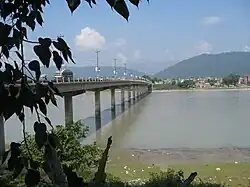
 Narayani Bridge seen from Narayangarh | |
| Coordinates | 27°41′58″N 84°25′08″E / 27.699516°N 84.418984°E |
| Crosses | Narayani River |
| Locale | |
| Characteristics | |
| Total length | 420m |
| History | |
| Opened | 1980s |
| Location | |
Narayani Bridge (Nepali: नारायणी पुल) is a bridge on the East-West (Mahendra highway) of Nepal located in the central region of Nepal. The bridge connects Gaindakot municipality of Nawalparasi District on the western region of Nepal,[1] with Narayanghat (Bharatpur, Nepal) city on the central development region. Built in the early 1980s, the bridge over the Narayani River is about 420 m (1,380 ft) long and is considered one of the important commercial life lines of the country.[2] It has 15 large and round shaped pillars.
References
- ↑ "ABOUT BHARATPUR, NEPAL". Retrieved 12 December 2017.
- ↑ "Narayani Bridge". Retrieved 12 December 2017.
This article is issued from Wikipedia. The text is licensed under Creative Commons - Attribution - Sharealike. Additional terms may apply for the media files.