| Newaygo State Park | |
|---|---|
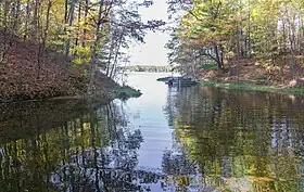
 Boat launch area | |
 Location in Michigan  Newaygo State Park (the United States) | |
| Location | Big Prairie Township, Newaygo County, Michigan, United States |
| Nearest city | Newaygo, Michigan |
| Coordinates | 43°30′09″N 85°35′30″W / 43.50250°N 85.59167°W[2] |
| Area | 257 acres (104 ha) |
| Elevation | 850 feet (260 m)[2] |
| Designation | Michigan state park |
| Established | 1966[3] |
| Administrator | Michigan Department of Natural Resources |
| Website | Newaygo State Park |
Newaygo State Park is a public recreation area covering 257 acres (104 ha) on the south side of Hardy Dam Pond in Big Prairie Township, Newaygo County, Michigan. The state park sits atop 20-foot (6.1 m) embankments overlooking the six-mile-long (10 km), 4,000-acre (1,600 ha) impoundment of the Muskegon River.[4]
History
The park was created in 1966 when the state leased acreage that included 4,500 feet (1,400 m) of water frontage from Consumers Power Company.[5]
Activities and amenities
The park offers swimming, fishing for bass, walleye and panfish, boat launch, picnicking, playground, and 99 rustic campsites.[4]
References
- ↑ "Newaygo State Park". IUCN. Retrieved April 24, 2020.
- 1 2 "Newaygo State Park". Geographic Names Information System. United States Geological Survey, United States Department of the Interior.
- ↑ "When were Michigan state parks and recreation areas established?" (PDF). Michigan Department of Natural Resources. Retrieved April 24, 2020.
- 1 2 "Newaygo State Park". Michigan Department of Natural Resources. Retrieved March 11, 2018.
- ↑ "Twenty-Third Biennial Report 1965–1966". State of Michigan Department of Conservation. p. 129. Retrieved March 11, 2018.
External links
- Newaygo State Park Michigan Department of Natural Resources
- Newaygo State Park Park Michigan Department of Natural Resources
This article is issued from Wikipedia. The text is licensed under Creative Commons - Attribution - Sharealike. Additional terms may apply for the media files.