Niedźwiadek | |
|---|---|
Neighbourhood and City Information System area | |
 The apartment buildings in Niedźwiadek, in 2017. | |
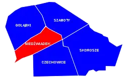
 Location of Niedźwiadek within the district of Ursus, in accordance to the City Information System. | |
| Coordinates: 52°11′48″N 20°52′15″E / 52.19667°N 20.87083°E | |
| Country | |
| Voivodeship | Masovian |
| City county | Warsaw |
| District | Ursus |
| Time zone | UTC+1 (CET) |
| • Summer (DST) | UTC+2 (CEST) |
| Area code | +48 22 |
Niedźwiadek[lower-alpha 1] is a residential neighbourhood, and an area of the City Information System, in the city of Warsaw, Poland, located within the district of Ursus.[1]
The neighbourhood was built between 1968 and 1977, to provide housing to the employees of the nearby Ursus factory.[2][3]
Characteristics
Public spaces

In Niedźwiadek is located Hass Park (Polish: Park Hassów), at the intersection of Wojciechowskiego Street, Czechowicza Street and Jagiełły Street. It forms an urban green space. It was named after the Hass family, who in 20th century, had donated this land to the city to form a park.[4]
Housing
Niedźwiadek is a residential area, with multifamily residential apartment buildings.[2]
Public transit and transport infrastructure

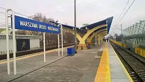
In Niedźwiadek is located the Warszawa Ursus-Niedźwiadek railway station, which lies on the railway line no. 447.[5][6][7] Though the neighborhood also goes the railway line no. 1.[1]
Through the western portion of Niedźwiadek goes a section of the Expressway S2.[2][8]
Religion
In Niedźwiadek, at 37 Zagłoby Street, is located the Our Lady of Fatima Sanctuary, which is the Roman Catholic parish church. It was built between 1984 and 1997.[9]
History
The construction of the neighbourhood of Niedźwiadek began in 1968, on an area previously covered by farmlands. The construction lasted until 1978. It was originally a neighbourhood of the town of Ursus, which in 1977 was incorporated into the city of Warsaw.[3] The neighbourhood was built by Robotnicza Spółdzielnia Mieszkaniowa Ursus (Ursus Worker's Housing Association), with the urban layout designed by Jerzy Gieysztor.[10] Niedźwiadek was built to provide housing to the employees of the nearby Ursus factory.[2]
Between 1984 and 1997, the Our Lady of Fatima Sanctuary, was built in Niedźwiadek, which is the Roman Catholic parish church.[9]
On 7 January 2014 the Warszawa Ursus-Niedźwiadek railway station was opened in Niedźwiadek.[5][6][7]
Locations and administrative boundaries
Niedźwiadek is located within the central-western portion of the district of Ursus, in the city of Warsaw, Poland. In accordance to the City Information System, its boundaries are determent by Warszawska Street to the north, Gierdziejewskiego Street, and Cierlicka Street to the east, the railway line no. 447 to the south, and the railway line no. 1 to the west.[1]
The neighbourhood borders Gołąbki to the north, Szamoty to the north-east, Skorosze to the south-east, Czechowice to the south, and Piastów to the south-west. The western border of the neighborhood marks the border of both the district of Ursus, and the city of Warsaw, and is adjusted to the town of Piastów in Pruszków County.[1]
Citations
Notes
References
- 1 2 3 4 "Obszary MSI. Dzielnica Ursus". zdm.waw.pl (in Polish).
- 1 2 3 4 Ula Olczak (5 September 2022). "Niedźwiadek – mieszkania. Dlaczego warto zamieszkać w tej lokalizacji?". obido.pl (in Polish).
- 1 2 "Historia Ursusa". ursus.warszawa.pl (in Polish).
- ↑ "Parki w Ursusie". ursus.um.warszawa.pl (in Polish).
- 1 2 "Pasażerowie mogą już korzystać z nowego przystanku Warszawa Ursus-Niedźwiadek". ztm.waw.pl (in Polish). 27 December 2013.
- 1 2 "Warszawa Ursus Niedźwiadek". atlaskolejowy.net (in Polish).
- 1 2 "Warszawa Ursus Niedźwiadek". bazakolejowa.pl (in Polish).
- ↑ Mapa lokalizacji węzłów drogowych wraz z ich numeracją zgodną z zasadami oznakowania eksperymentalnego. Warsaw: General Directorate for National Roads and Highways. 27 June 2022. (in Polish)
- 1 2 "Warszawa. Matki Bożej Fatimskiej". archwwa.pl (in Polish).
- ↑ "Zagłoby". utm.info.pl (in Polish).