| Nopiming Provincial Park | |
|---|---|
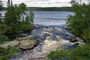
 Tulabi Falls | |
 | |
| Location | Manitoba, Canada |
| Nearest city | Winnipeg, Manitoba |
| Coordinates | 50°38′2″N 95°19′38″W / 50.63389°N 95.32722°W[1] |
| Area | 1,429 km2 (552 sq mi) |
| Established | 1976 |
| Governing body | Government of Manitoba |
Nopiming Provincial Park is a natural provincial park in Manitoba, Canada, located on the southeast side of the province, along the boundary with Ontario.[1]
The area was designated a provincial park by the Government of Manitoba in 1976.[2] The park is 1,429 square kilometres (552 sq mi) in size.[2] It is considered a Class II protected area under the IUCN protected area management categories.[3] The park preserves areas that are representative of the Lac Seul Upland portion of the Precambrian Boreal Forest natural region.[4]
The park's name comes from the Anishinaabe word noopiming, meaning "in the woods/brush" used in reference to coming off a lake and heading inland. Another translation of Nopiming from the Anishinaabe (Saulteaux) language is "Entrance to the Wilderness".[5]
Description

The area is mostly boreal forest and Canadian Shield with many lakes and rivers. There are a few gravel roads through the park, camping facilities, hiking trails, and a few cottages. The area is very remote and the most southern herd of woodland caribou can be found here. Further to the north is Atikaki Provincial Wilderness Park with no roads. Almost the entire east side of Lake Winnipeg is wilderness, with a few First Nation communities and very few small towns.
Both Booster Lake and Springer Lake are located in Nopiming Provincial Park.
Beresford Lake
Beresford Lake (50°52′14″N 95°14′04″W / 50.870556°N 95.234444°W) is in the park. The park has a campground that is made up of 28 sites including a boat launch. The lake is surrounded by boreal forest largely consisting of jack pine, poplar, tamarack, larch, black spruce, and birch. Wildlife present includes black bears and bald eagles. Fishing is a frequent activity, as is boating. The lakes are bordered with granite rock.[6]
Beresford Lake was once the site of a gold mine, the Gunnar gold mine, in 1937.[7]
Film
A film titled Nopiming Provincial Park 2 was made about forestry in the park in 2010. In the video is said "This video is part of the Developing Forest Services project funded by the Academy of Finland (project # 12340). It is intended to create dialogue about forest conflicts and use, and our conception of forests".
See also
References
- 1 2 "Natural Resources Canada-Canadian Geographical Names (Nopiming Provincial Park)". Retrieved 2015-01-22.
- 1 2 A System Plan for Manitoba's Provincial Park (PDF). Government of Manitoba. March 1997. p. 43. Archived from the original (PDF) on 15 July 2017. Retrieved 2 July 2017.
- ↑ "Nopiming Provincial Park". Protected Planet. United Nations Environment World Conservation Monitoring Centre. Retrieved 2 July 2017.
- ↑ Manitoba Sustainable Development. "EasternParks: Noping Provincial Park" (PDF). Retrieved 10 October 2022.
- ↑ "Parks and Protected Spaces | Conservation and Climate | Province of Manitoba". www.gov.mb.ca. Retrieved 2021-08-09.
- ↑ "Beresford Campground" (PDF). Nopiming Provincial Park. Retrieved February 15, 2016.
- ↑ Government of Canada, Natural Resources Canada (2015-12-07). "GEOSCAN Search Results: Fastlink". geoscan.nrcan.gc.ca. Retrieved 2020-05-16.
