Norris Arm | |
|---|---|
Town | |
 Seal | |
| Motto: "The Town With The Sensational Sunset" | |
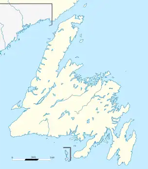 Norris Arm Location of Norris Arm in Newfoundland | |
| Coordinates: 49°05′N 55°16′W / 49.083°N 55.267°W | |
| Country | |
| Province | |
| Census division | 6 |
| Settled | 1700s |
| Incorporated (town) | 1971 |
| Government | |
| • Type | Town Council |
| • Mayor | Ross Rowsell |
| • MP | Clifford Small (CPC) |
| • MHA | Pleaman Forsey (PC) |
| Area | |
| • Total | 41.49 km2 (16.02 sq mi) |
| Elevation | 22 m (72 ft) |
| Population (2021)[1] | |
| • Total | 708 |
| • Density | 17/km2 (44/sq mi) |
| Time zone | UTC-3:30 (Newfoundland Time) |
| • Summer (DST) | UTC-2:30 (Newfoundland Daylight) |
| Postal Code Span | |
| Area code | 709 |
| Highways | |
| Website | https://municipalnl.ca/municipality/norris-arm/ |
Norris Arm is a town in north-central Newfoundland, Newfoundland and Labrador, Canada. It is in Division No. 6, on the Bay of Exploits.
Demographics
In the 2021 Census of Population conducted by Statistics Canada, Norris Arm had a population of 708 living in 334 of its 435 total private dwellings, a change of -3.9% from its 2016 population of 737. With a land area of 41.35 km2 (15.97 sq mi), it had a population density of 17.1/km2 (44.3/sq mi) in 2021.[1]
Climate
| Climate data for Norris Arm | |||||||||||||
|---|---|---|---|---|---|---|---|---|---|---|---|---|---|
| Month | Jan | Feb | Mar | Apr | May | Jun | Jul | Aug | Sep | Oct | Nov | Dec | Year |
| Record high °C (°F) | 13.5 (56.3) |
14 (57) |
17 (63) |
23.5 (74.3) |
29 (84) |
33 (91) |
34 (93) |
35 (95) |
30 (86) |
25.6 (78.1) |
21.1 (70.0) |
17.8 (64.0) |
35 (95) |
| Mean daily maximum °C (°F) | −2 (28) |
−2.2 (28.0) |
1.7 (35.1) |
6.4 (43.5) |
13 (55) |
18.8 (65.8) |
23.4 (74.1) |
22.1 (71.8) |
17.1 (62.8) |
11 (52) |
5.9 (42.6) |
0.5 (32.9) |
9.7 (49.5) |
| Daily mean °C (°F) | −6.8 (19.8) |
−7.4 (18.7) |
−3 (27) |
2.2 (36.0) |
7.8 (46.0) |
13 (55) |
17.7 (63.9) |
16.7 (62.1) |
12 (54) |
6.7 (44.1) |
2.2 (36.0) |
−3.6 (25.5) |
4.8 (40.6) |
| Mean daily minimum °C (°F) | −11.8 (10.8) |
−12.8 (9.0) |
−7.8 (18.0) |
−2 (28) |
2.5 (36.5) |
7.1 (44.8) |
11.9 (53.4) |
11.3 (52.3) |
6.9 (44.4) |
2.4 (36.3) |
−1.6 (29.1) |
−7.9 (17.8) |
−0.2 (31.6) |
| Record low °C (°F) | −32.8 (−27.0) |
−36.7 (−34.1) |
−32 (−26) |
−18.5 (−1.3) |
−9.4 (15.1) |
−3.5 (25.7) |
0 (32) |
−0.6 (30.9) |
−3.3 (26.1) |
−10 (14) |
−20 (−4) |
−33.3 (−27.9) |
−36.7 (−34.1) |
| Average precipitation mm (inches) | 108 (4.3) |
92.3 (3.63) |
105.6 (4.16) |
82.4 (3.24) |
81.7 (3.22) |
85.3 (3.36) |
80.4 (3.17) |
103.1 (4.06) |
82.7 (3.26) |
104.4 (4.11) |
100.5 (3.96) |
107.8 (4.24) |
1,134.2 (44.65) |
| Source: 1961-1990 Environment Canada[2] | |||||||||||||
See also
References
- 1 2 "Population and dwelling counts: Canada, provinces and territories, census divisions and census subdivisions (municipalities), Newfoundland and Labrador". Statistics Canada. February 9, 2022. Retrieved March 15, 2022.
- ↑ Environment Canada—1961–1990. Retrieved 15 October 2012.
External links
- Flying Boat Festival International
- Norris Arm - Encyclopedia of Newfoundland and Labrador, vol. 4, p. 97-98.
Places adjacent to Norris Arm | |
|---|---|
Division No. 6, Newfoundland and Labrador (Central Newfoundland) | ||
|---|---|---|
| Towns |  | |
| Unorganized subdivisions | ||
| Designated places | ||
This article is issued from Wikipedia. The text is licensed under Creative Commons - Attribution - Sharealike. Additional terms may apply for the media files.