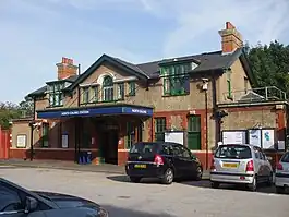
| North Ealing | |
|---|---|
 | |
 North Ealing Location of North Ealing in Greater London | |
| Location | Ealing |
| Local authority | London Borough of Ealing |
| Managed by | London Underground |
| Number of platforms | 2 |
| Fare zone | 3 |
| London Underground annual entry and exit | |
| 2018 | |
| 2019 | |
| 2020 | |
| 2021 | |
| 2022 | |
| Railway companies | |
| Original company | District Railway |
| Key dates | |
| 23 June 1903 | Station opened |
| 4 July 1932 | District line service replaced by Piccadilly line |
| Listed status | |
| Listing grade | II |
| Entry number | 1390751[6] |
| Added to list | 30 October 2003 |
| Other information | |
| External links | |
| WGS84 | 51°31′03″N 0°17′19″W / 51.51750°N 0.28861°W |
North Ealing is a London Underground station on the Uxbridge branch of the Piccadilly line between Ealing Common and Park Royal. The station is located on Station Road, a short distance from the junction of Queen's Drive and Hanger Lane (A406, North Circular Road). It is in Travelcard Zone 3. West Acton station on the Central line is located about 550 metres to the east at the other end of Queen's Drive.
Despite its name, the station is geographically located to the east of Ealing Broadway; the areas of Gurnell, Pitshanger, Montpelier and Hanger Hill/Hanger Lane are more geographically suited to the term "North Ealing". There is even a primary school named North Ealing within Pitshanger.
History
North Ealing station was opened on 23 June 1903 by the District Railway (DR, now the District line) on its new extension from north of Ealing Common to Park Royal & Twyford Abbey (closed and replaced by Park Royal in 1931), where the Royal Agricultural Society's Park Royal show grounds had been recently opened. The line was opened fully to South Harrow on 28 June 1903.
This new extension was, together with the existing tracks between Ealing Common and Acton Town, the first section of the Underground's surface lines to be electrified and operate electric instead of steam trains. The deep-level tube lines open at that time (City & South London Railway, Waterloo & City Railway and Central London Railway) had been electrically powered from the start.
North Ealing was the only station on the South Harrow branch not rebuilt in the 1930s to the "Holden" style for the start of the Piccadilly Line service. As a result, it retains its slightly rural air. A 1930s railway sub-station is built alongside the Eastbound platform and is typical of the LPTB brick and concrete architectural style of the period.
On 4 July 1932 the Piccadilly line was extended to run west of its original terminus at Hammersmith sharing the route with the District line to Ealing Common. From Ealing Common to South Harrow, the District line was replaced by the Piccadilly line and, from this date, District line trains west from Ealing Common ran to Ealing Broadway only.
In 2018, it was announced that the station would gain step free access by 2022, as part of a £200M investment to increase the number of accessible stations on the Tube.[7]
Services
The peak time service in trains per hour (tph) is:[8]
- 12tph to Cockfosters (Eastbound)
- 6tph to Rayners Lane (Westbound)
- 6tph to Uxbridge via Rayners Lane (Westbound)
The off-peak service in trains per hour (tph) is:[8]
- 6tph to Cockfosters (Eastbound)
- 3tph to Rayners Lane (Westbound)
- 3tph to Uxbridge via Rayners Lane (Westbound)
Connections
London Buses routes 112, 483 and night route N83 serve the station.[9]
Gallery
 Looking westbound towards Park Royal
 Looking eastbound towards Ealing Common
 Looking west from footbridge
 Roundel
 Main Entrance
References
- ↑ "Station Usage Data" (CSV). Usage Statistics for London Stations, 2018. Transport for London. 23 September 2020. Archived from the original on 14 January 2023. Retrieved 11 October 2023.
- ↑ "Station Usage Data" (XLSX). Usage Statistics for London Stations, 2019. Transport for London. 23 September 2020. Archived from the original on 9 November 2020. Retrieved 9 November 2020.
- ↑ "Station Usage Data" (XLSX). Usage Statistics for London Stations, 2020. Transport for London. 16 April 2021. Retrieved 1 January 2022.
- ↑ "Station Usage Data" (XLSX). Usage Statistics for London Stations, 2021. Transport for London. 12 July 2022. Retrieved 7 September 2022.
- ↑ "Station Usage Data" (XLSX). Usage Statistics for London Stations, 2022. Transport for London. 4 October 2023. Retrieved 10 October 2023.
- ↑ Historic England. "North Ealing London Regional Transport Underground Station (1390751)". National Heritage List for England. Retrieved 31 July 2013.
- ↑ "Huge boost for accessibility as further 13 stations to go step-free". London City Hall. 19 January 2018. Retrieved 2 February 2018.
- 1 2 "Archived copy" (PDF). Archived from the original (PDF) on 1 July 2016. Retrieved 31 May 2016.
{{cite web}}: CS1 maint: archived copy as title (link) - ↑ "Buses from Ealing Common" (PDF). TfL. 15 July 2023. Retrieved 14 July 2023.
External links
| Preceding station | Following station | |||
|---|---|---|---|---|
| Park Royal towards Uxbridge or Rayners Lane |
Piccadilly line | Ealing Common towards Cockfosters or Arnos Grove | ||
| Former services | ||||
| Preceding station | Following station | |||
| Park Royal & Twyford Abbey towards South Harrow or Uxbridge |
District line (1903–1931) |
Ealing Common towards Upminster | ||
| Park Royal towards South Harrow or Uxbridge |
District line (1931–1932) |
|||