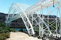
Old Trails Bridge | |
 Old Trails Bridge in September 2002 | |
 Old Trails Bridge  Old Trails Bridge  Old Trails Bridge  Old Trails Bridge | |
| Location | Abandoned US 66 over the Colorado River, south of Tiprock, Arizona United States |
|---|---|
| Coordinates | 34°42′57″N 114°29′5″W / 34.71583°N 114.48472°W |
| Area | 0.3 acres (0.12 ha) |
| Built | 1915-16 |
| Built by | Sourwine, S.A.; Et al. |
| Architectural style | Brace-ribbed through arch |
| MPS | Vehicular Bridges in Arizona MPS |
| NRHP reference No. | 88001676[1] |
| Added to NRHP | September 30, 1988 |
The Old Trails Bridge is a historic bridge over the Colorado River in San Bernardino County and Mohave County in the United States, that is listed on the National Register of Historic Places (NRHP).[1] It has also been known as Topock Bridge and as Needles Bridge.[2][3]
Description and history

The bridge carried a now-abandoned section of the former U.S. Route 66 across from southeast of Needles, California to south of Toprock, Arizona. It is a brace-ribbed through arch bridge that was built in 1915–1916.[4] It served as a highway bridge until 1947 when the Red Rock Bridge, formerly a railroad bridge, was modified for highway use. The Old Trails Bridge was later converted to a pipeline bridge.
It was listed on the NRHP on September 30, 1988.[1][4]
The bridge has been seen in a number of blockbuster films including The Grapes of Wrath and Easy Rider.
See also
References
- 1 2 3 "National Register Information System". National Register of Historic Places. National Park Service. July 9, 2010.
- ↑ "CHS.J3009". digital.denverlibrary.org. Retrieved January 21, 2023.
- ↑ "Old Trails Arch Bridge". Bridgehunter.com. Retrieved January 21, 2023.
- 1 2 Clayton B. Fraser (April 1, 1987). "HABS/HAER Inventory: Old Trails Bridge / Topock Bridge / Needles Bridge". National Park Service. and accompanying photos
External links
- Photo at Flickr, in higher resolution