Orange Cove, California | |
|---|---|
| City of Orange Cove | |
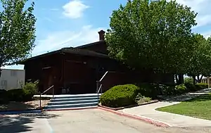
 City Hall located in the former Orange Cove Santa Fe Railway Depot | |
 Location in Fresno County and the U.S. state of California | |
 Orange Cove, California Location in the United States | |
| Coordinates: 36°37′28″N 119°18′49″W / 36.62444°N 119.31361°W | |
| Country | United States |
| State | California |
| County | Fresno |
| Incorporated | January 20, 1948[1] |
| Government | |
| • Mayor | Diana Guerra Silva [2] |
| • Mayor Pro Tem | Diana Guerra Silva[2] |
| • State Senator | Anna Caballero (D)[3] |
| • Assemblymember | Joaquin Arambula (D)[4] |
| • U. S. Rep. | David Valadao (R)[5] |
| Area | |
| • Total | 1.79 sq mi (4.64 km2) |
| • Land | 1.79 sq mi (4.64 km2) |
| • Water | 0.00 sq mi (0.00 km2) 0% |
| Elevation | 423 ft (129 m) |
| Population (2010) | |
| • Total | 9,078 |
| • Estimate (2019)[8] | 10,273 |
| • Density | 5,732.70/sq mi (2,213.65/km2) |
| Time zone | UTC-8 (PST) |
| • Summer (DST) | UTC-7 (PDT) |
| ZIP codes | 93646, 93675 |
| Area code | 559 |
| FIPS code | 06-54008 |
| GNIS feature IDs | 277569, 2411327 |
| Website | www |
Orange Cove is a city in Fresno County, California, United States. The population was 9,078 at the 2010 census, up from 7,722 at the 2000 census.
Description
Almost all of Orange Cove's residents are Hispanic, many of them farmers.[9] Orange Cove is located in the San Joaquin Valley, 8 miles (13 km) east-northeast of Reedley,[10] at an elevation of 423 feet (129 m).[7]
Geography
According to the United States Census Bureau, the city has a total area of 1.9 square miles (4.9 km2), all of its land.
Climate
According to the Köppen Climate Classification system, Orange Cove has a hot-summer Mediterranean climate, abbreviated "Csa" on climate maps.[11]
History
Elmer M. Sheridan founded the town in 1914, and named it prior to large scale citrus growing.[10] The first post office opened in 1914.[10] The city incorporated in 1948.[10]
Demographics
| Census | Pop. | Note | %± |
|---|---|---|---|
| 1950 | 2,392 | — | |
| 1960 | 2,885 | 20.6% | |
| 1970 | 3,392 | 17.6% | |
| 1980 | 4,027 | 18.7% | |
| 1990 | 5,608 | 39.3% | |
| 2000 | 7,721 | 37.7% | |
| 2010 | 9,073 | 17.5% | |
| 2019 (est.) | 10,273 | [8] | 13.2% |
| U.S. Decennial Census[12] | |||
2010
At the 2010 census Orange Cove had a population of 9,078. The population density was 47,488,869.6 people per square mile (1,800/km2). The racial makeup of Orange Cove was 3,940 (43.4%) White, 72 (0.8%) African American, 131 (1.4%) Native American, 101 (1.1%) Asian, 3 (0.03%) Pacific Islander, 4,481 (49.4%) from other races, and 350 (3.9%) from two or more races. Hispanic or Latino of any race were 8,413 persons (92.7%).[13]
The census reported that 9,078 people (100% of the population) lived in households, no one lived in non-institutionalized group quarters and no one was institutionalized.
There were 2,068 households, out of which 1,459 (70.6%) had children under the age of 18 living in them, 1,202 (58.1%) were opposite-sex married couples living together, 430 (20.8%) had a single female householder, 222 (10.7%) had a single male householder. There were 207 (10%) unmarried opposite-sex partnerships, and 10 (0.5%) same-sex married couples or partnerships. 174 households (8.4%) were one person and 88 (4.3%) had someone living alone who was 65 or older. The average household size was 4.39. There were 1,854 families (89.7% of all households); the average family size was 4.53.
The age distribution was 3,619 people (39.9%) under the age of 18, 1,113 people (12.3%) aged 18 to 24, 2,398 people (26.4%) aged 25 to 44, 1,435 people (15.8%) aged 45 to 64, and 513 people (5.7%) who were 65 or older. The median age was 23.6 years. For every 100 females, there were 100.9 males. For every 100 females age 18 and over, there were 100.1 males.
There were 2,231 housing units at an average density of 1,167.0 per square mile (450/km2), of which 2,068 were occupied, of which 893 (43.2%) were owner-occupied, and 1,175 (56.8%) were occupied by renters. The homeowner vacancy rate was 0.8%; the rental vacancy rate was 9.5%. 4,047 people (44.6% of the population) lived in owner-occupied housing units and 5,031 people (55.4%) lived in rental housing units.
2000
At the 2000 census there were 7,722 people, 1,694 households, and 1,512 families in the city. The population density was 5,030.4 people per square mile (1,900/km2). There were 1,767 housing units at an average density of 1,151.1 per square mile (440/km2). The racial makeup of the city was 33.55% White, 0.31% Black or African American, 2.42% Native American, 1.49% Asian, 58.84% from other races, and 3.38% from two or more races. 90.60% of the population were Hispanic or Latino of any race.[14] There were 1,694 households, 62.7% had children under the age of 18 living with them, 61.2% were married couples living together, 18.6% had a female householder with no husband present, and 10.7% were non-families. 7.1% of households were one person and 3.7% were one person aged 65 or older. The average household size was 4.56 and the average family size was 4.66.
The age distribution was 40.4% under the age of 18, 13.9% from 18 to 24, 28.1% from 25 to 44, 12.6% from 45 to 64, and 5.0% 65 or older. The median age was 23 years. For every 100 females, there were 107.7 males. For every 100 females age 18 and over, there were 108.7 males.
The median income for a household in the city was US$22,357, and the median family income was $22,525. Males had a median income of $21,042 versus $16,821 for females. The per capita income for the city was $7,126. About 39.9% of families and 44.5% of the population were below the poverty line, including 54.6% of those under age 18 and 20.0% of those age 65 or over.
Municipal government
Orange Cove's local government includes an elected mayor, mayor pro tem, and a three-member city council.[15] As of 2020, its current mayor is Victor P. Lopez.[15] Lopez was mayor of Orange Cove for over three decades before being voted out of office in 2010.[16] He was later elected to the city council in 2013 and re-elected as mayor in 2014 in what he claimed would be his last term in office,[17] but he then went on to win re-election as mayor again in 2018.[18]
Police department
The community of Orange Cove maintained its own police department for many years. In 1992 however, the city disbanded its police department, due to an inadequate budget and began contracting with the Fresno County Sheriff's Department for police services.
As of December 16, 2009, the city restarted its police department. Frank Steenport was the Chief.[19] Later, Marty Rivera became the Chief of Police.[20]
Education
Schools in Orange Cove are part of the Kings Canyon Unified School District. Orange Cove has one High School (Orange Cove High School) and Middle School (Citrus Middle School) as well as three Elementary Schools: Sheridan Elementary School, McCord Elementary School, and A.L. Conner Elementary School.
Parks
- U.S Senator Dianne Feinstein Park
- P. Rod Skate Park
- BMX Park
- Sheridan Park
- James O. Eaton Memorial Park, Javier Bejar Memorial
Health care
- Adventist Health Medical Office
- United Health Centers of the San Joaquin Valley
Transportation
Orange Cove is served by State Route 63 (SR 63), which approaches the city from Orosi. SR 63 bypasses the city along Hills Valley Road, while straddling the Fresno–Tulare county line, and continues north toward SR 180. Hills Valley Road continues south as County Route J19, which connects to Reedley (via Manning Avenue) and Dinuba.[21]
Orange Cove was formerly served by the Atchison, Topeka and Santa Fe Railway along its Porterville-Orosi District branch line. The station serving this line was listed on the National Register of Historic Places in 1978.[22]
See also
References
- ↑ "California Cities by Incorporation Date". California Association of Local Agency Formation Commissions. Archived from the original (Word) on October 17, 2013. Retrieved April 6, 2013.
- 1 2 "City Council". City of Orange Cove. Retrieved January 5, 2015.
- ↑ "Senators". State of California. Retrieved April 6, 2013.
- ↑ "Members Assembly". State of California. Retrieved April 6, 2013.
- ↑ "California's 22nd Congressional District - Representatives & District Map". Civic Impulse, LLC. Retrieved April 6, 2013.
- ↑ "2019 U.S. Gazetteer Files". United States Census Bureau. Retrieved July 1, 2020.
- 1 2 "Orange Cove". Geographic Names Information System. United States Geological Survey, United States Department of the Interior.
- 1 2 "Population and Housing Unit Estimates". United States Census Bureau. May 24, 2020. Retrieved May 27, 2020.
- ↑ "U.S. Census website". United States Census Bureau. Retrieved March 29, 2020.
- 1 2 3 4 Durham, David L. (1998). California's Geographic Names: A Gazetteer of Historic and Modern Names of the State. Clovis, Calif.: Word Dancer Press. p. 1084. ISBN 1-884995-14-4.
- ↑ Climate Summary for Orange Cove, California
- ↑ "Census of Population and Housing". Census.gov. Retrieved June 4, 2015.
- ↑ "2010 Census Interactive Population Search: CA - Orange Cove city". U.S. Census Bureau. Archived from the original on July 15, 2014. Retrieved July 12, 2014.
- ↑ "U.S. Census website". United States Census Bureau. Retrieved January 31, 2008.
- 1 2 "City Council - OrangeCove". City Council - OrangeCove. Retrieved September 27, 2020.
- ↑ "A three-decade mayor, recently ousted, is back in office". Los Angeles Times. January 6, 2013. Retrieved September 27, 2020.
- ↑ "Victor Lopez re-elected as Orange Cove mayor". Victor Lopez re-elected as Orange Cove mayor. Retrieved September 27, 2020.
- ↑ "2018 November General Election Results". 2018 November General Election Results. Retrieved September 27, 2020.
- ↑ "Orange Cove Welcomes New Police Department". KMPH Fox 26 News. Sinclair Broadcast Group, Inc. December 16, 2009. Retrieved January 29, 2021.
- ↑ "Staff". Welcome to the City of Orange Cove. Retrieved July 13, 2017.
- ↑ Google (May 17, 2023). "Road network in the vicinity of Orange Cove, California" (Map). Google Maps. Google. Retrieved May 17, 2023.
- ↑ "National Register Information System – (#78000668)". National Register of Historic Places. National Park Service. July 9, 2010.

