Palmyra Township | |
|---|---|
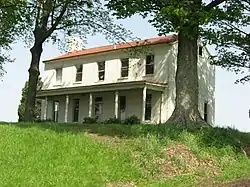 Rose Hill Farmstead, a historic site in the township | |
 | |
| Coordinates: 38°40′49″N 87°24′34″W / 38.68028°N 87.40944°W | |
| Country | United States |
| State | Indiana |
| County | Knox |
| Government | |
| • Type | Indiana township |
| Area | |
| • Total | 37.48 sq mi (97.1 km2) |
| • Land | 37.47 sq mi (97.0 km2) |
| • Water | 0.01 sq mi (0.03 km2) |
| Elevation | 505 ft (154 m) |
| Population (2010) | |
| • Total | 1,466 |
| • Density | 39.1/sq mi (15.1/km2) |
| FIPS code | 18-57744[2] |
| GNIS feature ID | 453704 |
Palmyra Township is one of ten townships in Knox County, Indiana. As of the 2010 census, its population was 1,466 and it contained 612 housing units.[3]
History
Shadowwood was added to the National Register of Historic Places in 2001.[4] Rose Hill Farmstead was formerly listed.[5]
Geography
According to the 2010 census, the township has a total area of 37.48 square miles (97.1 km2), of which 37.47 square miles (97.0 km2) (or 99.97%) is land and 0.01 square miles (0.026 km2) (or 0.03%) is water.[3]
References
- ↑ "US Board on Geographic Names". United States Geological Survey. October 25, 2007. Retrieved January 31, 2008.
- ↑ "U.S. Census website". United States Census Bureau. Retrieved January 31, 2008.
- 1 2 "Population, Housing Units, Area, and Density: 2010 - County -- County Subdivision and Place -- 2010 Census Summary File 1". United States Census. Archived from the original on February 12, 2020. Retrieved May 10, 2013.
- ↑ "National Register Information System". National Register of Historic Places. National Park Service. July 9, 2010.
- ↑ "National Register of Historic Places Listings". Weekly List of Actions Taken on Properties: 6/11/12 through 6/15/12. National Park Service. June 22, 2012.
External links
Municipalities and communities of Knox County, Indiana, United States | ||
|---|---|---|
| Cities | Map of Indiana highlighting Knox County | |
| Towns | ||
| Townships | ||
| CDPs | ||
| Other communities | ||
This article is issued from Wikipedia. The text is licensed under Creative Commons - Attribution - Sharealike. Additional terms may apply for the media files.