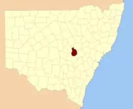
Gordon
New South Wales
Location in New South Wales
Lands administrative divisions around Gordon:
Narromine Lincoln Bligh
Kennedy Gordon Wellington
Ashburnham Ashburnham Wellington

Gordon County is one of the 141 Cadastral divisions of New South Wales. The Macquarie River is the north-eastern boundary.

Gordon County was named in honour of George Hamilton Gordon, Fourth Earl of Aberdeen (1784-1860).[1]

Parishes within this county

A full list of parishes found within this county; their current LGA and mapping coordinates to the approximate centre of each location is as follows:

ParishLGACoordinates
BelmoreCabonne Shire Council32°37′54″S 148°25′04″E / 32.63167°S 148.41778°E / -32.63167; 148.41778 (Belmore)
BenolongDubbo Regional Council32°25′54″S 148°39′04″E / 32.43167°S 148.65111°E / -32.43167; 148.65111 (Benolong)
BenyaCabonne Shire Council32°57′54″S 148°33′04″E / 32.96500°S 148.55111°E / -32.96500; 148.55111 (Benya)
BolderogeryCabonne Shire Council32°48′54″S 148°36′04″E / 32.81500°S 148.60111°E / -32.81500; 148.60111 (Bolderogery)
BuckinbahCabonne Shire Council32°47′54″S 148°40′04″E / 32.79833°S 148.66778°E / -32.79833; 148.66778 (Buckinbah)
BurgoonCabonne Shire Council32°51′54″S 148°38′04″E / 32.86500°S 148.63444°E / -32.86500; 148.63444 (Burgoon)
BurrawongCabonne Shire Council32°50′54″S 148°44′04″E / 32.84833°S 148.73444°E / -32.84833; 148.73444 (Burrawong)
CalomaDubbo Regional Council32°29′54″S 148°30′04″E / 32.49833°S 148.50111°E / -32.49833; 148.50111 (Caloma)
CardingtonCabonne Shire Council32°50′54″S 148°55′04″E / 32.84833°S 148.91778°E / -32.84833; 148.91778 (Cardington)
CatombalDubbo Regional Council32°47′54″S 148°49′04″E / 32.79833°S 148.81778°E / -32.79833; 148.81778 (Catombal)
CullenDubbo Regional Council32°25′54″S 148°24′04″E / 32.43167°S 148.40111°E / -32.43167; 148.40111 (Cullen)
CurraDubbo Regional Council32°36′54″S 148°54′04″E / 32.61500°S 148.90111°E / -32.61500; 148.90111 (Curra)
DilgaCabonne Shire Council32°56′54″S 148°40′04″E / 32.94833°S 148.66778°E / -32.94833; 148.66778 (Dilga)
DrawayDubbo Regional Council32°35′54″S 148°35′04″E / 32.59833°S 148.58444°E / -32.59833; 148.58444 (Draway)
DubboDubbo Regional Council32°13′54″S 148°35′04″E / 32.23167°S 148.58444°E / -32.23167; 148.58444 (Dubbo Regional Council)
EurimbulaCabonne Shire Council32°53′54″S 148°49′04″E / 32.89833°S 148.81778°E / -32.89833; 148.81778 (Eurimbula)
GanooDubbo Regional Council32°39′54″S 148°41′04″E / 32.66500°S 148.68444°E / -32.66500; 148.68444 (Ganoo)
GilgalDubbo Regional Council32°31′54″S 148°38′04″E / 32.53167°S 148.63444°E / -32.53167; 148.63444 (Gilgal)
GullengambelDubbo Regional Council32°36′54″S 148°32′04″E / 32.61500°S 148.53444°E / -32.61500; 148.53444 (Gullengambel)
GundyDubbo Regional Council32°34′54″S 148°51′04″E / 32.58167°S 148.85111°E / -32.58167; 148.85111 (Gundy)
HyandraCabonne Shire Council32°52′54″S 148°26′04″E / 32.88167°S 148.43444°E / -32.88167; 148.43444 (Hyandra)
LoombahDubbo Regional Council32°45′54″S 148°44′04″E / 32.76500°S 148.73444°E / -32.76500; 148.73444 (Loombah)
NarragalDubbo Regional Council32°46′54″S 148°57′04″E / 32.78167°S 148.95111°E / -32.78167; 148.95111 (Narragal)
NeureaDubbo Regional Council32°46′54″S 148°53′04″E / 32.78167°S 148.88444°E / -32.78167; 148.88444 (Neurea)
ObleyCabonne Shire Council32°44′54″S 148°36′04″E / 32.74833°S 148.60111°E / -32.74833; 148.60111 (Obley)
OxleyDubbo Regional Council32°25′54″S 148°32′04″E / 32.43167°S 148.53444°E / -32.43167; 148.53444 (Oxley)
PontoDubbo Regional Council32°30′54″S 148°49′04″E / 32.51500°S 148.81778°E / -32.51500; 148.81778 (Ponto)
RedbankDubbo Regional Council32°34′54″S 148°44′04″E / 32.58167°S 148.73444°E / -32.58167; 148.73444 (Redbank)
RocheDubbo Regional Council32°30′54″S 148°33′04″E / 32.51500°S 148.55111°E / -32.51500; 148.55111 (Roche)
Rocky PondsCabonne Shire Council31°59′54″S 148°30′04″E / 31.99833°S 148.50111°E / -31.99833; 148.50111 (Rocky Ponds)
StrathornCabonne Shire Council32°44′54″S 148°23′04″E / 32.74833°S 148.38444°E / -32.74833; 148.38444 (Strathorn)
TerrabellaDubbo Regional Council32°28′54″S 148°45′04″E / 32.48167°S 148.75111°E / -32.48167; 148.75111 (Terrabella)
The GapCabonne Shire Council32°56′54″S 148°45′04″E / 32.94833°S 148.75111°E / -32.94833; 148.75111 (The Gap)
The SpringsDubbo Regional Council32°29′54″S 148°39′04″E / 32.49833°S 148.65111°E / -32.49833; 148.65111 (The Springs)
VeechDubbo Regional Council32°40′54″S 148°46′04″E / 32.68167°S 148.76778°E / -32.68167; 148.76778 (Veech)
WagstaffCabonne Shire Council32°46′54″S 148°31′04″E / 32.78167°S 148.51778°E / -32.78167; 148.51778 (Wagstaff)
WandawandongCabonne Shire Council32°44′54″S 148°32′04″E / 32.74833°S 148.53444°E / -32.74833; 148.53444 (Wandawandong)
WarraberryCabonne Shire Council32°53′54″S 148°33′04″E / 32.89833°S 148.55111°E / -32.89833; 148.55111 (Warraberry)
WhylandraDubbo Regional Council32°20′54″S 148°34′04″E / 32.34833°S 148.56778°E / -32.34833; 148.56778 (Whylandra)

References

  1. "Gordon County". Geographical Names Register (GNR) of NSW. Geographical Names Board of New South Wales.
This article is issued from Wikipedia. The text is licensed under Creative Commons - Attribution - Sharealike. Additional terms may apply for the media files.