| Maintained by | City of Cleveland |
|---|---|
| Length | 2.42 mi (3.89 km)[1] |
| West end | |
| Major junctions | |
| East end | |
| Construction | |
| Construction start | October 1985 |
| Completion | October 8, 1988 |
The C.S.M. Paul B. Huff Medal of Honor Memorial Parkway, more commonly known as Paul Huff Parkway or simply Paul Huff, is a major east–west thoroughfare which runs through northern Cleveland, Tennessee. While not a numbered highway, it serves as a connector between U.S. Route 11 (US 11) and State Route 60 (SR 60) as well as to Interstate 75 (I-75), and has come to be one of the most heavily traveled and widely used roads in the city, with many corporate and private businesses locating to it.
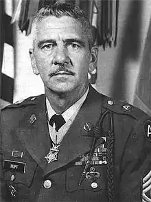
Paul Huff Parkway was originally constructed between 1985 and 1988 to serve as a connector between I-75 and an industrial area in the northeastern part of Cleveland. Since then, its corridor has grown to become the top producer of sales tax revenue in the city.[2] In 2022 the parkway had an annual average daily traffic (AADT) volume of 28,502 vehicles, one of the highest volumes on any road in the area.[3] The road is named in honor of Paul B. Huff, a Cleveland-born U.S. Army soldier and Medal of Honor recipient who served in World War II.
Route description
Paul Huff Parkway is located entirely within the city limits of Cleveland in Bradley County, and is maintained by the City of Cleveland's Public Works Department. It is one of the few locally maintained and non-numbered routes that is part of the National Highway System (NHS), a national network of roads identified as important to the national economy, defense, and mobility.[4][5] In 2022, traffic volumes on the parkway ranged from 28,502 vehicles per day between Freedom Parkway and a connector road to the Bradley Square Mall, and 15,403 vehicles per day between Candies Creek Ridge Road near the western terminus and Adkisson Drive/Frontage Road.[3]
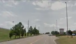
Paul Huff Parkway begins at an intersection with SR 60 (Georgetown Road) in the northwestern part of the city. An extension of the road exists approximately 1⁄8 mile (0.20 km) west of the intersection serving commercial properties. It then immediately crosses Candies Creek Ridge as an undivided four-lane road. At the bottom of the ridge it comes to an intersection with Adkisson Drive/Frontage Road, where a center (turn) lane begins. Adkisson Drive connects to Cleveland State Community College a short distance to the south. About 0.2 miles (0.32 km) later the road comes to an intersection with an interchange with I-75. Afterwards the road enters a large business area, skirting the edge of a few residential neighborhoods, and comes to an intersection with Peerless Road. About 1⁄4 mile (0.40 km) later it reaches Mouse Creek Road, which serves a number of residential neighborhoods to the north. The road then passes between an elementary school and a shopping center on the opposite side, before coming to an intersection with Freedom Parkway. It then passes a fire and ambulance station and crosses South Mouse Creek (commonly referred to as Mouse Creek) and the Cleveland/Bradley County Greenway. Ascending to the top of a minor ridge, the road intersects two unnamed connector roads that provide access to the Bradley Square Mall to the north and Hickory Grove Shopping Center and other commercial establishments to the south. Approximately 1⁄4 mile (0.40 km) later the road comes to an intersection with US 11 (SR 2, Keith Street/North Lee Highway) where it ends and continues east as Stuart Road.[6][7]
History
Background and construction
The road that is now Paul Huff Parkway was first planned as part of a connector road between I-75 and industrial parks on the northeastern part of the city.[8][9] At the time, most of the land through which it passes was still farmland and woodlands, although residential development had already begun to occur nearby.[10] A project that preceded the parkway was the construction of Stuart Road (originally Industrial Park Road) between US 11 and Old Tasso Road in 1971,[11] and the extension of this road eastward to Michigan Avenue Road, which was let in December 1982 and completed on June 27, 1984.[9] Many residents in the area were opposed to the parkway's construction, as they felt it would bring unwanted commercial development, which it eventually did. In response, the city and state reached a land use agreement in 1983 that required restrictions on access points on the stretch between I-75 and Mouse Creek Road, but still acknowledged that the areas would eventually be developed.[12][13][14] That same year, an activist group composed of local residents was formed to campaign against commercial rezoning along the road. Concerns were also raised about safety at the Mouse Creek Road intersection and the parkway's proximity to an elementary school, which prompted the state to agree to construct a berm separating the school.[12]
The contract for the section between Mouse Creek Road and US 11 was awarded in October 1985,[15] and the contract for the section between Adkisson Drive/Frontage Road and Mouse Creek Road, including the I-75 interchange, was awarded the following month.[16][17] Most of the latter section replaced part of Valley Head Road, a two-lane road that ran from the Adkisson Drive/Frontage Road intersection, under I-75, and ended near what is now the intersection with Peerless Road.[18]</ref>[19] The section between Adkisson Drive/Frontage Road and Mouse Creek Road was completed in July 1987.[20] The section between Mouse Creek Road and US 11 was completed the following month.[21][22] The section over Candies Creek Ridge was let in September 1987 and opened on October 8, 1988.[23][24] This project was very laborious, requiring work crews to blast out and move tons of earth and rock, and stabilize the sides of the ridge between the road.[10] Not initially planned to take place for many more years, this project was made possible by the passage of the Better Roads Program by the Tennessee General Assembly in 1986.[25] While the entire road was constructed by the Tennessee Department of Transportation (TDOT), maintenance was turned over to the city once construction was complete.[8][17]
The road was initially known as the Valley Head Connector Road. While still under construction, the local Veterans of Foreign Wars post began a push to name the road after Sgt. Paul B. Huff.[19][26] On October 5, 1987, the Bradley County Commission voted to name the road after Huff,[27] followed by the Cleveland City Commission one week later.[28] The parkway was dedicated in honor of Sgt. Paul B. Huff on Veterans Day, November 11, 1988.[19][29][30]
Later history
Following the opening of the Bradley Square Mall in 1991, the parkway saw a boom of commercial development from the late 1990s to the mid 2000s.[31][32] These included several strip malls including the Hickory Grove Shopping Center as well as such stores as Lowe's and The Home Depot, and several restaurants and hotels. This resulted in a rapid increase in congestion and crashes, prompting some residents to oppose additional developments on the parkway.[33][34] From December 2003 to January 2004, traffic lights were installed at the intersections with the I-75 ramps.[35] An additional signal was installed in July 2004 at the intersection of Freedom Parkway, which was constructed to serve the new Home Depot.[36] In 2015, a short extension of the road was constructed west of SR 60.[37] In December of that year, the first traffic light in Cleveland with a flashing yellow arrow was installed at the intersection between the parkway and SR 60.[38] The speed limit was reduced from 50 to 45 miles per hour (80 to 72 km/h) in early 2016, and that same year, city officials began debating proposed safety improvements to the parkway.[39]
The parkway saw additional booms in commercial development in the early 2010s and from the late 2010s to the early 2020s.[40][41] These developments resulted in additional traffic congestion and hazards on the parkway, and further criticisms from motorists. By 2018, the accident rate on parts of the parkway was five times greater than that of the area, prompting the city to begin preliminary plans for safety improvements to the corridor.[42] In October 2019, the first blank-out sign in Cleveland, which restricts right turns on red when illuminated, was installed at the intersection of Paul Huff Parkway and Peerless Road.[43] On October 14, 2021, TDOT broke ground on a widening project on the connecting section of SR 60, which will include the construction of additional turn lanes at the intersection with the parkway.[44][45] In early 2022 the city announced that a total of nine improvement projects were planned for the parkway.[46] The first project, which took place from June 2022 to November 2023, expanded the Mouse Creek Road intersection by adding turn lanes to both routes and through lanes to the latter road.[47] The next projects, which are expected to begin in 2024, include improvements to the intersection with Peerless Road and both intersections with the I-75 ramps.[48]
Proposed extension
A residential construction boom began in the 1990s along Freewill Road, located approximately 3⁄4 mile (1.2 km) west of the western terminus of Paul Huff Parkway. In response to increased traffic commuting from this area into Cleveland, a concept for extending Paul Huff Parkway to Freewill Road arose. In 2003, a study conducted by TDOT found that the extension would be too expensive for the city to fund on its own.[49] The project again resurfaced in early 2009, when the city listed the project as a need.[50] In early 2011, the Cleveland Area Metropolitan Planning Organization listed the extension as a possible future project pending federal funding.[51] In 2020, the extension received further momentum as additional residential growth occurred in the western part of the city.[52]
Major intersections
The entire route is in Cleveland, Bradley County.
| mi[1] | km | Destinations | Notes | ||
|---|---|---|---|---|---|
| 0.00 | 0.00 | Continues west to a dead end | |||
| 0.92 | 1.48 | Diamond interchange; I-75 exit 27 | |||
| 2.42 | 3.89 | Continues east as Stuart Road | |||
| 1.000 mi = 1.609 km; 1.000 km = 0.621 mi | |||||
See also
References
- 1 2 Bureau of Transportation Statistics (June 13, 2022). "National Highway Planning Network" (Map). National Transportation Atlas Database. Washington, D.C.: United States Department of Transportation. Retrieved April 29, 2023.
- ↑ Siniard, Tim; Mincey, Allen (December 17, 2021). "2021 Newsmakers: Paul Huff Parkway lands at No. 6". Cleveland Daily Banner. Archived from the original on December 18, 2021. Retrieved December 1, 2023.
- 1 2 Tennessee Department of Transportation. "Transportation Data Management System". ms2soft.com. MS2. Retrieved November 27, 2021.
- ↑ National Highway System: Cleveland, TN (PDF) (Map). Federal Highway Administration. October 1, 2012. Retrieved July 27, 2023.
- ↑ Natzke, Stefan; Neathery, Mike & Adderly, Kevin (August 26, 2010). "What is the National Highway System?". National Highway System. Federal Highway Administration. Retrieved December 12, 2010.
- ↑ DeLorme (2017). Tennessee Atlas & Gazetteer (Map) (2017 ed.). 1 in:2.5 mi. Yarmouth, Maine: DeLorme. ISBN 978-1946494047.
- ↑ Tennessee Department of Transportation Long Range Planning Division Office of Data Visualization (2018). Bradley County (PDF) (Map). Tennessee Department of Transportation.
- 1 2 Norton, Rick (July 1, 1984). "Road project outlined". Cleveland Daily Banner. pp. 1, 3.
- 1 2 Craig, David B. (June 27, 1984). "Stuart Road extended". Cleveland Daily Banner. pp. 1, 10.
- 1 2 Guthrie, Chet (July 23, 2015). "Busy street once site of the Guthrie farm". Cleveland Daily Banner. Cleveland, Tennessee. Archived from the original on July 26, 2015. Retrieved July 5, 2018.
- ↑ "Harriman Firm Low Bidder on Interstate Link". The Knoxville News-Sentinel. May 5, 1971. p. 34. Retrieved December 1, 2023 – via Newspapers.com.
- 1 2 Norton, Rick (July 8, 1986). "Valleyhead connector zoning sparks discord". Cleveland Daily Banner. pp. 1, 11.
- ↑ Seay, Kimberly (July 25, 1998). "Public hearing for parkway set for Monday". Cleveland Daily Banner. Retrieved December 1, 2023.
- ↑ de Medici, Elizabeth (October 29, 2002). "Home Depot passes on first reading". Cleveland Daily Banner. Retrieved December 1, 2023.
- ↑ "Notice to Contractors of State Highway Construction Bids To Be Received September 30, 1985". The Commercial Appeal. Memphis. August 30, 1985. p. A12. Retrieved October 26, 2023 – via Newspapers.com.
- ↑ "Notice to Contractors of State Highway Construction Bids To Be Received November 1, 1985". The Tennessean. Nashville. October 11, 1985. p. 11-C. Retrieved October 26, 2023 – via Newspapers.com.
- 1 2 Norton, Rick (November 19, 1985). "City fathers are given update on road projects". Cleveland Daily Banner. p. 2.
- ↑ United States Geological Survey (1976). East Cleveland, Tenn (Topographic map). 1:24,000. 7.5 Minute Series. Reston, Virginia: United States Geological Survey. Retrieved July 27, 2023.
- 1 2 3 Zolvinski, Steve (November 4, 1988). "Medal Of Honor Winner Huff To Be Honored With Road Name". The Leaf-Chronicle. p. 1B. Retrieved December 1, 2023 – via Newspapers.com.
- ↑ Norton, Rick (July 21, 1987). "I-75 interchange nearing completion". Cleveland Daily Banner. pp. 1, 14.
- ↑ Norton, Rick (August 18, 1987). "Craigmiles House use OK'd; part of I-75 connector opened". Cleveland Daily Banner. pp. 1, 9.
- ↑ Norton, Rick (August 21, 1987). "Local road jobs talked". Cleveland Daily Banner. pp. 1, 12.
- ↑ Norton, Rick (September 22, 1987). "Michigan firm low bidder". Cleveland Daily Banner. p. 1.
- ↑ Norton, Rick (October 11, 1988). "Huff Parkway western extension open". Cleveland Daily Banner. p. 2.
- ↑ Henry, Douglas; Darnell, Riley; Bragg, John; Robinson, C. Robb (April 1, 1986). 1986 Road Program (PDF) (Report). Tennessee Department of Transportation. Retrieved April 26, 2020.
- ↑ Norton, Rick (September 29, 1987). "City asked to rename street for Medal of Honor winner". Cleveland Daily Banner. pp. 1, 13.
- ↑ Mincey, Allen (October 6, 1987). "County votes to name road after war hero Paul B. Huff". Cleveland Daily Banner. pp. 1, 9.
- ↑ Norton, Rick (October 13, 1987). "City okays road honoring Paul Huff". Cleveland Daily Banner. p. 1.
- ↑ "Command Sergeant Major (Retired) Paul B. Huff". 509thgeronimo.com. 509th Infantry Regiment. 2006. Retrieved November 3, 2017.
- ↑ "Work begins on Hickory Grove Center; tenants are announced". Cleveland Daily Banner. June 4, 1999. Retrieved December 1, 2023.
- ↑ Graves, Brian (February 10, 2016). "Bradley Square Mall turns 25". Cleveland Daily Banner. Archived from the original on February 11, 2016. Retrieved November 13, 2017.
- ↑ Reynolds, Jason M. (June 29, 2004). "Stores spring up at crossroads". Chattanooga Times Free Press. Retrieved December 1, 2023.
- ↑ Higgins, Randall (August 26, 2004). "Reaction mixed on Paul Huff development". Chattanooga Times Free Press. Retrieved December 1, 2023.
- ↑ "Work started on traffic signals". Chattanooga Times Free Press. December 25, 2003. Retrieved December 1, 2023.
- ↑ Harris, Ryan (July 24, 2004). "Activation of traffic signal set for Tuesday". Cleveland Daily Banner. Retrieved December 1, 2023.
- ↑ Leach, Paul (August 25, 2015). "Cleveland hits brakes on Paul Huff Parkway extension". Chattanooga Times Free Press. Retrieved November 3, 2017.
- ↑ "'Flashing yellow arrow' introduced to city signals". Cleveland Daily Banner. December 2, 2015. Archived from the original on December 12, 2015. Retrieved December 1, 2023.
- ↑ Love, Joyanna (April 15, 2016). "Huff traffic safety debated by city". Cleveland Daily Banner. Retrieved December 1, 2023.
- ↑ Higgins, Randall (September 3, 2011). "Cleveland boom; Paul Huff Parkway sees increasing development". Chattanooga Times Free Press. Retrieved December 1, 2023.
- ↑ Bowers, Larry C. (December 18, 2019). "No. 8: Huff Puffs". Cleveland Daily Banner. Archived from the original on December 18, 2019. Retrieved December 1, 2023.
- ↑ Siniard, Tim (August 14, 2018). "City Council mulls Paul Huff lane changes". Cleveland Daily Banner. Archived from the original on August 14, 2018. Retrieved December 1, 2023.
- ↑ "City Installs First Blank-Out Sign" (Press release). City of Cleveland, Tennessee. October 9, 2019. Retrieved December 1, 2023.
- ↑ Benton, Ben (October 14, 2021). "Cleveland's $54 million State Route 60 widening project breaks ground". Chattanooga Times Free Press. Retrieved October 14, 2021.
- ↑ "State Route 60 from North of I-75 to State Route 306 (Eureka Road)". tn.gov. Nashville: Tennessee Department of Transportation. Retrieved December 1, 2023.
- ↑ Siniard, Tim (March 2, 2022). "City cracks $100 million in infrastructure enhancements". Cleveland Daily Banner. Retrieved December 1, 2023.
- ↑ Siniard, Tim (November 16, 2023). "Mouse Creek intersection features extra lanes, new traffic arms". Cleveland Daily Banner. Retrieved December 1, 2023.
- ↑ Bromley, Grant (November 4, 2023). "Fivas tells Rotarians of expansion projects in Cleveland". Cleveland Daily Banner. Retrieved December 1, 2023.
- ↑ Higgins, Randall (July 6, 2003). "Paul Huff Parkway extension costs considered too expensive". Chattanooga Times Free Press. Retrieved December 1, 2023.
- ↑ Higgins, Randall (February 14, 2009). "Cleveland seeks flood study funds". Chattanooga Times Free Press. Retrieved December 1, 2023.
- ↑ Higgins, Randall (January 15, 2011). "Plan may include Huff Parkway extension". Chattanooga Times Free Press. Retrieved December 1, 2023.
- ↑ Siniard, Tim (July 30, 2020). "Extending Paul Huff Parkway on the western end a possibility". Cleveland Daily Banner. Archived from the original on August 1, 2020. Retrieved December 1, 2023.