Piaski | |
|---|---|
Neighbourhood and City Information System area | |
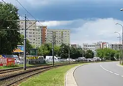
 Władysława Broniewskiego Street in Piaski, in 2017. | |
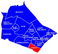
 Location of Piaski within the district of Bielany, in accordance to the City Information System. | |
| Coordinates: 52°16′06.77″N 20°56′36.77″E / 52.2685472°N 20.9435472°E | |
| Country | |
| Voivodeship | Masovian |
| City county | Warsaw |
| District | Bielany |
| Time zone | UTC+1 (CET) |
| • Summer (DST) | UTC+2 (CEST) |
| Area code | +48 22 |
Piaski[lower-alpha 1] is a neighbourhood, and an area of the City Information System, in the city of Warsaw, Poland, located within the district of Bielany.[1]
History
The area of modern Piaski used to be covered by sandy dunes, and remained mostly underdeveloped until the 1970s.[2]
The year 1888 marks the first known mention of the village of Młociny B (possibly an abbreviation to Młociny Burakowskie; literally: Młociny of Buraków), located within the modern area of Piaski. It was located near the village of Buraków.[3][2] In 1892, the barracks of the Imperial Russian Army had been built in the area. The complex consisted of around 120 wooden and brick buildings.[4] It also the included military training area.[5]
On 8 April 1916, the area was incorporated into the city of Warsaw.[6][7] After the year 1918, Młociny B had been renamed to Piaski. The name translates in Polish to sands and was a reference to the sandy dunes characteristic to the area.[3][2]
Following the declaration of independence by the Second Polish Republic, the barracks and the surrounding military infrastructure began being used by the Polish Armed Forces. In the 1930s, in the area was also placed a railway training centre, to train railway workers. Some historians suspect, that the training centre was a cover for the secret operations of the Second Department of Polish General Staff, an intelligence agency of Polish Armed Forces.[5]
During the Second World War, while under the German occupation, in the area was located the training centre of Abwehr, the military intelligence of Wehrmacht, and later also the military hospital, mainly for the soldiers injured at the Eastern Front. Following the end of the war, until October 1949, in the area was located Soviet prisoner-of-war camp. In 1949, it housed almost 300 prisoners-of-war.[5]

In the 1970s, Piaski began being developed as a residential neighbourhood. Between 1970 and 1973, the multifamily residential apartment buildings were built around the Broniewskiego Street.[8] The major development began in 1978, with the construction of the first apartment buildings around Zegrzyńska Street. In the early 1980s, the architect Józef Zbigniew Polak had designed the apparent complex at Sybiraków Avenue, to form the shape of four stars, the symbol of the general of the army of the Polish Armed Forces. It was done to honour general Wojciech Jaruzelski, who at the time was the Prime Minister of Poland and the commander-in-chief of the Polish Armed Forces.[5]
In the 1980s, in Piaski was built an amphitheatre, which became a characteristic object of the neighbourhood. By 1990s, it become abandoned, and was eventually torn down, and replaced by Kaufland supermarket.[5][9]
In 1990, in the area was opened the Police Training Centre.[5]
In 2002, 4 Niedzielskiego Street was built the Church of St. Christopher, a Roman Catholic parish church.[10][11]
Since 2019, at the crossing of Sybiraków Avenue and Piaskowska Street, is being built a nine-story apartment building, the first skyscraper in Piaski. It is planned to have 96 apartments. It replaced the building commonly known as Okrąglak, which housed the branch of the PKO Bank Polski, and characteristic to the neighbourhood.[5][12]
Characteristics
Piaski is a residential neighbourhood, mostly consisting of the apartment buildings.[2][5]
At 4 Niedzielskiego Street is located the Church of St. Christopher, a Roman Catholic parish church.[10][11]
Location and administrative boundaries
Piaski is located within the southeastern portion of the district of Bielany, in the city of Warsaw, Poland. It is a City Information System area. To the north, its border is determined by Broniewskiego Street; to the east, by Armii Ludowej Avenue; to the south, by Maczka Street, Powązkowska Street, Rudnickiego Street, and around the area of the building complex at 1 Rudnickiego Street and 1A Rudnickiego Street; and to the west, by Reymonta Street.[1]
It borders Old Bielany, and Słodowiec to the north, Sady Żoliborskie to the east, Fort Bema to the south, Lotnisko to the south-west, and Chomiczówka to the west. Its eastern and southern boundaries form the border of the district of Bielany, bordering districts of Żoliborz to the east, and Bemowo to the south.[1]
Citations
Notes
References
- 1 2 3 "Obszary MSI. Dzielnica Bielany". zdm.waw.pl (in Polish).
- 1 2 3 4 "Osiedle na wydmie. Jak powstawały Piaski?". tustolica.pl (in Polish). 19 December 2016.
- 1 2 Jarosław Zieliński: Bielany. Przewodnik historyczny. Warsaw: Bielany District Management. 2016. p. 224.
- ↑ "Osiedle Piaski na dawnej fotografii". muzeum.legionowo.pl (in Polish). 2017.
- 1 2 3 4 5 6 7 8 "Osiedle Piaski - dawniej i dziś. 'Bardzo ciepłe wspomnienia'". tustolica.pl (in Polish). 14 December 2020.
- ↑ Dziennik Zarządu Miasta Stołecznego Warszawy, no 129, 27 October 1917.
- ↑ Maria Nietyksza, Witold Pruss: Zmiany w układzie przestrzennym Warszawy. In: Irena Pietrza-Pawłowska (editor): Wielkomiejski rozwój Warszawy do 1918 r., issue 43. Warsaw: Wydawnictwo Książka i Wiedza, p. 1973.
- ↑ Encyklopedia Warszawy. Warsaw: Polish Scientific Publishers PWN, 1994, p. 629. ISBN 83-01-08836-2.
- ↑ "Pamiętacie jeszcze amfiteatr na Piaskach?". tustolica.pl (in Polish). 17 December 2014.
- 1 2 Robert Stępisiewicz, Sławomir H. Zaręba, Witold Zdaniewicz (editors): Wykaz parafii w Polsce 2006. Według diecezji: stan na 31.12.2005 r., vol. 2. Warsaw: Instytut Statystyki Kościoła Katolickiego SAC. 2006.
- 1 2 Tomasz Gołąb (6 September 2020). "Kard. Kazimierz Nycz na Bielanach: To miejsce jest święte". warszawa.gosc.pl (in Polish).
- ↑ "Koniec 'okrąglaka' na Piaskach, czas na wieżowiec". tustolica.pl (in Polish). 4 June 2019.
