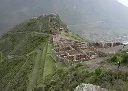
Pisac
P'isaq | |
|---|---|
 Pisac | |
.png.webp) Coat of arms | |
| Country | |
| Region | Cusco |
| Province | Calca |
| Capital | Pisac |
| Government | |
| • Mayor | Gavino Yucra Tunqui |
| Area | |
| • Total | 148.25 km2 (57.24 sq mi) |
| Elevation | 2,972 m (9,751 ft) |
| Population | |
| • Total | 9,239 |
| • Density | 62/km2 (160/sq mi) |
| Time zone | UTC-5 (PET) |
| UBIGEO | 080405 |
Pisac District is one of eight districts of the province Calca in Peru.[1]
Geography
Some of the highest mountains of the district are listed below:[2]
- Hatun Wayllarani
- Ichhunayuq
- Machu Kuntur Sinqa
- Ñustapata
- Pukayuq
- Q'ispi Urqu
Ethnic groups
The people in the district are mainly indigenous citizens of Quechua descent. Quechua is the language which the majority of the population (72.23%) learnt to speak in childhood, 27.15% of the residents started speaking using the Spanish language (2007 Peru Census).[3]
Climate
| Climate data for Pisac (elevation 2,990 m (9,810 ft), 1991–2020 normals) | |||||||||||||
|---|---|---|---|---|---|---|---|---|---|---|---|---|---|
| Month | Jan | Feb | Mar | Apr | May | Jun | Jul | Aug | Sep | Oct | Nov | Dec | Year |
| Mean daily maximum °C (°F) | 21.8 (71.2) |
21.5 (70.7) |
22.0 (71.6) |
22.7 (72.9) |
23.4 (74.1) |
23.2 (73.8) |
23.0 (73.4) |
23.4 (74.1) |
23.6 (74.5) |
23.7 (74.7) |
24.3 (75.7) |
22.7 (72.9) |
22.9 (73.3) |
| Mean daily minimum °C (°F) | 10.1 (50.2) |
10.0 (50.0) |
9.7 (49.5) |
8.2 (46.8) |
6.1 (43.0) |
4.6 (40.3) |
4.2 (39.6) |
5.3 (41.5) |
7.5 (45.5) |
9.2 (48.6) |
9.8 (49.6) |
10.0 (50.0) |
7.9 (46.2) |
| Average precipitation mm (inches) | 119.1 (4.69) |
99.8 (3.93) |
83.2 (3.28) |
26.4 (1.04) |
7.0 (0.28) |
4.6 (0.18) |
5.6 (0.22) |
6.3 (0.25) |
11.2 (0.44) |
39.7 (1.56) |
56.7 (2.23) |
99.3 (3.91) |
558.9 (22.01) |
| Source: National Meteorology and Hydrology Service of Peru[4] | |||||||||||||
See also
References
- ↑ (in Spanish) Instituto Nacional de Estadística e Informática. Banco de Información Distrital Archived 2008-04-23 at the Wayback Machine. Retrieved April 11, 2008.
- ↑ escale.minedu.gob.pe - UGEL map of the Calca Province (Cusco Region)
- ↑ inei.gob.pe Archived 2013-01-27 at the Wayback Machine INEI, Peru, Censos Nacionales 2007, Frequencias: Preguntas de Población
- ↑ "Normales Climaticás Estándares y Medias 1991-2020". National Meteorology and Hydrology Service of Peru. Archived from the original on 21 August 2023. Retrieved 25 October 2023.
| |
|---|---|
| Acomayo | |
| Anta | |
| Calca | |
| Canas | |
| Canchis | |
| Chumbivilcas | |
| Cusco | |
| Espinar | |
| La Convención | |
| Paruro | |
| Paucartambo | |
| Quispicanchi | |
| Urubamba | |
This article is issued from Wikipedia. The text is licensed under Creative Commons - Attribution - Sharealike. Additional terms may apply for the media files.