| Piz Nair | |
|---|---|
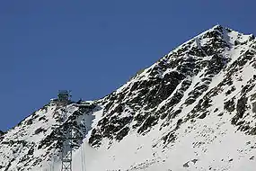
 Piz Nair cable car station in 2006 | |
| Highest point | |
| Elevation | 3,056 m (10,026 ft) |
| Prominence | 183 m (600 ft)[1] |
| Parent peak | Piz Ot |
| Coordinates | 46°30′22.5″N 9°47′14.8″E / 46.506250°N 9.787444°E |
| Geography | |
 Piz Nair Location in Switzerland | |
| Location | Graubünden, Switzerland |
| Parent range | Albula Alps |
| Climbing | |
| Easiest route | Cable car |
Piz Nair (3,056 metres (10,026 ft)) is a mountain of the Albula Alps in Switzerland, overlooking St. Moritz in the canton of Graubünden. The peak is easily accessible from the village with a funicular and a cable car; the upper station unloads 30 metres (100 ft) below the summit. Below the summit to the east is the Corviglia ski area.
The mountain hosted the alpine skiing events for the 1948 Winter Olympics in neighboring St. Moritz.[2] It also hosted the World Championships in 1934, 1974, 2003, and 2017.
Gallery
 The Engadin Valley from the summit
 Corviglia intermediate station
See also
References
- ↑ Retrieved from the Swisstopo topographic maps. The key col is the Fuorcla Schlattain (2,873 m).
- ↑ 1948 Winter Olympics official report. pp. 6, 21. (in French and German)
External links
![]() Media related to Piz Nair at Wikimedia Commons
Media related to Piz Nair at Wikimedia Commons
This article is issued from Wikipedia. The text is licensed under Creative Commons - Attribution - Sharealike. Additional terms may apply for the media files.

