Postjesbuurt | |
|---|---|
Neighbourhood of Amsterdam | |
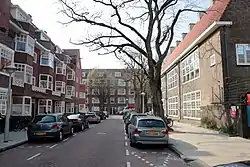
 Arubastraat in 2019 | |
 Location (red) in Amsterdam | |
| Country | Netherlands |
| Province | North Holland |
| Municipality | Amsterdam |
| Borough | Amsterdam-West |
| Time zone | UTC+1 (CET) |
| • Summer (DST) | UTC+2 (CEST) |
Postjesbuurt (Dutch pronunciation: [ˈpɔscəzˌbyːrt]) or Westindische buurt (Dutch pronunciation: [ˈʋɛst.ɪndisəˌbyːrt]) is a neighbourhood in Amsterdam, Netherlands. Since 2010, it is part of the district of De Baarsjes[1] and the borough of Amsterdam-West.[2]
The boundaries of the neighbourhood are Postjeswetering in the west and north, Kostverlorenvaart in the east, and Surinameplein in the south.[3]
References
- ↑ "Oud-West, De Baarsjes" (in Dutch), Municipality of Amsterdam. Retrieved 9 August 2021.
- ↑ "Stadsdeel West" (in Dutch), Municipality of Amsterdam. Retrieved 9 August 2021.
- ↑ "Kaart van Postjesbuurt" (in Dutch), Kaart van Amsterdam. Retrieved 7 August 2021.
This article is issued from Wikipedia. The text is licensed under Creative Commons - Attribution - Sharealike. Additional terms may apply for the media files.