Preston, Pennsylvania | |
|---|---|
| Township of Preston | |
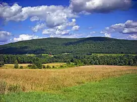
 Mount Ararat, the highest point in Wayne County, viewed from Crosstown Highway between Pennsylvania Route 171 (PA-171) and Belmont Turnpike. | |
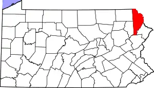
 Location in Wayne County and the state of Pennsylvania. | |
| Country | United States |
| State | Pennsylvania |
| US Congressional District | PA-8 |
| State Senatorial District | 20 |
| State House of Representatives District | 111 |
| County | Wayne |
| School District | Wayne Highlands Region I |
| Settled | c. 1812[1] |
| Incorporated | April 28th, 1828[2] |
| Founded by | Peter Spencer and Ezra Spencer[1] |
| Named for | Samuel Preston, Sr.[1] |
| Government | |
| • Type | Board of Supervisors |
| • Board of Supervisors[3] | Supervisors |
| • US Representative | Matt Cartwright (D) |
| • State Senator | Lisa Baker (R) |
| • State Representative | Sandra Major (R) |
| Area | |
| • Total | 51.55 sq mi (133.51 km2) |
| • Land | 49.42 sq mi (128.00 km2) |
| • Water | 2.13 sq mi (5.51 km2) |
| Elevation | 2,077[5] ft (633 m) |
| Population (2010) | |
| • Total | 1,014 |
| • Estimate (2016)[6] | 977 |
| • Density | 19.77/sq mi (7.63/km2) |
| Time zone | UTC-5 (Eastern (EST)) |
| • Summer (DST) | UTC-4 (Eastern Daylight (EDT)) |
| Area code(s) | 570 |
| GNIS feature ID | 1217249[5] |
| FIPS code | 42-127-62600[7] |
| Website | Preston Township |
Preston is a second-class township in Wayne County, Pennsylvania, United States. The township's population was 1,014 at the time of the 2010 United States Census.[8]
Geography
According to the United States Census Bureau, Preston Township has a total area of 51.546 sq mi (133.51 km2), of which 49.419 sq mi (128.00 km2) is land and 2.127 sq mi (5.510 km2), or 4.126%, is water.[9]
The township and surrounding area has been called "the highlands of Wayne [County]" because it is especially mountainous.[10] About half of the highest peak in the county, Mount Ararat (historically called Ararat Mountain,[11] Ararat Peak,[12] Ararat Summit,[13] or simply "Ararat"[13]), is located in the village of Orson (the other half of it is in Belmont Corners in Mount Pleasant Township), as is the entirety of Sugarloaf Mountain[14] (formerly called Sugar Loaf Peak[12] or Sugar-loaf Mountain[11]), another especially prominent summit.
It is also known for its abundance of lakes, most of which are fed by natural springs on their lake bottoms.[10] As a result of this latter fact, combined with its generally high elevation, two significant Pennsylvania rivers, the Lackawanna and the Lackawaxen, begin in Preston Township. Specifically, Bone Pond[15] (or Summit Lake[16]) and Lake Lorain[17] (or Five Mile Pond[18]) in the village of Poyntelle and Independent Lake[19] (formerly known as Independence Pond[11] or Independent Pond,[20] and sometimes known today as Lake Independence[21] or Lake Independent[22]) in Poyntelle and Orson are three of the four sources of the East Branch of the Lackawanna (the fourth being Dunn Pond,[23] or Dunns Lake,[24] in the village of East Ararat in Ararat Township in Susquehanna County), while the West Branch of the Lackawaxen rises from a confluence of several small, unnamed streams in Orson and Poyntelle.
Communities
The following villages are located in Preston Township:
Demographics
| Census | Pop. | Note | %± |
|---|---|---|---|
| 2010 | 1,014 | — | |
| 2016 (est.) | 977 | [6] | −3.6% |
| U.S. Decennial Census[33] | |||
As of the Census of 2010, there were 1,014 people, 439 households, and 292 families in Preston Township. The township's population density was 20.52 people per square mile (7.922/km2), and there were 983 housing units at an average density of 19.9/sq mi (7.68/km2). The racial makeup of the populace was 98.6% White, 0.0% African American, 0.1% Native American, 0.4% Asian, 0.0% Pacific Islander, 0.0% of other races, and 0.9% of two or more races. Hispanics and Latinos of all races made up 0.5% of the population.[9][8]
66.5% of Preston Township's households were families, 56.7% were headed by a heterosexual married couple (Pennsylvania did not allow same-sex marriage until May 20, 2014, after the 2010 Census had been completed), and 22.3% included children under the age of 18. 6.2% of households were headed by a female householder with no husband present, 3.6% by a male householder with no wife present, and 33.5% consisted of non-families. 27.8% of all households were made up of individuals, and 10.4% consisted of a person 65 years of age or older living alone. The average household size was 2.31 and the average family size was 2.81.[8]
Preston Townships's age distribution was 19.7% under the age of 18, 2.8% between the ages of 18 and 24, 22.7% between 25 and 44, 35.3% between 45 and 64, and 19.5% 65 years of age or older. The population's median age was 48.0 years. For every 100 females, there were 98.0 males. For every 100 females age 18 and over, there were 99.0 males in the same age range.[8]
According to American Community Survey (ACS) estimates, the median income for a household in Preston Township in 2013 was $49,167, and the median income for a family was $68,594. Males had a median income of $30,850, while females had a median income of $32,125. The per capita income for the township was $25,393. 5.7% of families and 15.5% of people were below the Census Bureau's poverty thresholds (different from the federally defined poverty guidelines), including 26.0% of those under age 18 and 3.7% of those age 65 or over.[34][35]
According to self-reported ancestry figures recorded by the ACS, the five largest ancestral groups in Preston Township in 2013 were Germans (27.3%), English (22.5%), Irish (17.6%), Poles (13.3%), and Russians (5.5%). Those reporting American ancestry made up 3.4% of the population.[36]
Education
For children in grades K through 8, Preston Township is primarily served by the Preston Area School in Lakewood, part of the Wayne Highlands School District.[37] Because there are no private or parochial schools within the township, high school students (grades 9 through 12) may attend one of two public high schools. Honesdale High School, the only public high school in the district, or Hancock High school located in Hancock, NY. Both schools offer a unique education experience. Honesdale High school has a large diverse student body with many extracurricular activities. Hancock being a much smaller school offers the students much more individual teaching environment.
References
- 1 2 3 Goodrich, Phineas G. (1992) [1880]. History of Wayne County. Baltimore: Gateway Press, Inc. p. 240.
- ↑ Goodrich. p. 239.
- ↑ "Preston Township". Preston Township. PrestonTownship.com. 2013. Retrieved November 22, 2014.
- ↑ "2016 U.S. Gazetteer Files". United States Census Bureau. Retrieved August 14, 2017.
- 1 2 "Township of Preston". Geographic Names Information System. United States Geological Survey, United States Department of the Interior. January 1, 1990. Retrieved June 29, 2015.
- 1 2 "Population and Housing Unit Estimates". Retrieved June 9, 2017.
- ↑
U.S. Census Bureau. Census 2000. "Census Demographic Profiles, Preston Township" (PDF). CenStats Databases. Retrieved January 31, 2009.
{{cite web}}: CS1 maint: numeric names: authors list (link) - 1 2 3 4 Profile of General Population and Housing Characteristics: 2010 Demographic Profile Data for Preston Township, Pennsylvania (Report). U.S. Department of Commerce. 2010. Archived from the original on February 13, 2020. Retrieved June 29, 2015.
- 1 2 2014 Census National County Subdivisions Gazetteer File for Pennsylvania (Report). U.S. Department of Commerce. 2014. Retrieved June 29, 2015.
- 1 2 Pennsylvania State Commissioners of Fisheries (1897). Report of the State Commissioners of Fisheries. Harrisburg: Clarence M. Busch. p. 269. Retrieved March 11, 2015.
- 1 2 3 Goodrich, Phineas G. (1992) [1880]. History of Wayne County. Baltimore: Gateway Press, Inc. p. 239.
- 1 2 White, Israel Charles; Dolph, John M. (1881). The Geology of Susquehanna County and Wayne County (Report). Vol. 23. Board of Commissioners for the Second Geological Survey of Pennsylvania. p. 17. Retrieved March 11, 2015.
- 1 2 "Mount Ararat". Geographic Names Information System. United States Geological Survey. August 2, 1979. Retrieved November 4, 2014.
- ↑ "Sugarloaf Mountain". Geographic Names Information System. United States Geological Survey. August 2, 1979. Retrieved November 4, 2014.
- ↑ "Bone Pond". Geographic Names Information System. United States Geological Survey. August 2, 1979. Retrieved November 17, 2014.
- ↑ Water Supply Commission of Pennsylvania (1917). Water Resource Inventory Report (Report). Vol. 4. Wm. Stanley Ray, State Printer. p. 29. Retrieved November 4, 2014.
- ↑ "Lake Lorain". Geographic Names Information System. United States Geological Survey. August 2, 1979. Retrieved November 17, 2014.
- ↑ Water Supply Commission of Pennsylvania. p. 65.
- ↑ "Independent Lake". Geographic Names Information System. United States Geological Survey. August 2, 1979. Retrieved November 4, 2014.
- ↑ Water Supply Commission of Pennsylvania. p. 90.
- ↑ "Camp Map". Camp Westmont. Camp Westmont, Inc. Retrieved November 10, 2014.
- ↑ "Map". Independent Lake Camp. 1.I.L., Inc. 2015. Retrieved March 10, 2015.
- ↑ "Dunn Pond". Geographic Names Information System. United States Geological Survey. August 2, 1979. Retrieved November 17, 2014.
- ↑ Water Supply Commission of Pennsylvania. p. 57.
- 1 2 3 4 5 6 7 8 9 "PRESTON: SECOND CLASS TOWNSHIP MAP" (PDF). Pennsylvania Department of Transportation. Commonwealth of Pennsylvania. June 19, 1998. Retrieved November 20, 2014.
- ↑ "Wayne County Pennsylvania Railroad Stations". Pennsylvania Railroad Stations Past & Present. Dan West. 2014. Retrieved November 20, 2014.
- ↑ "Preston Corner". Geographic Names Information System. United States Geological Survey. August 2, 1979. Retrieved November 20, 2014.
- ↑ "Preston Center". Geographic Names Information System. United States Geological Survey. August 2, 1979. Retrieved November 20, 2014.
- ↑ "Preston Park". Geographic Names Information System. United States Geological Survey. August 2, 1979. Retrieved November 20, 2014.
- ↑ "Shehawken". Geographic Names Information System. United States Geological Survey. August 2, 1979. Retrieved November 20, 2014.
- ↑ "Tallmanville". Geographic Names Information System. United States Geological Survey. August 2, 1979. Retrieved November 20, 2014.
- ↑ "Wrighter Corner". Geographic Names Information System. United States Geological Survey. August 2, 1979. Retrieved November 20, 2014.
- ↑ "Census of Population and Housing". Census.gov. Retrieved June 4, 2016.
- ↑ SELECTED ECONOMIC CHARACTERISTICS 2009-2013 American Community Survey 5-Year Estimates for Preston Township, Pennsylvania (Report). U.S. Department of Commerce. 2013. Archived from the original on February 13, 2020. Retrieved June 29, 2015.
- ↑ OCCUPATION BY SEX AND MEDIAN EARNINGS IN THE PAST 12 MONTHS (IN 2013 INFLATION-ADJUSTED DOLLARS) FOR THE CIVILIAN EMPLOYED POPULATION 16 YEARS AND OVER 2009-2013 American Community Survey 5-Year Estimates for Preston Township, Pennsylvania (Report). U.S. Department of Commerce. 2013. Archived from the original on February 13, 2020. Retrieved June 29, 2015.
- ↑ SELECTED SOCIAL CHARACTERISTICS IN THE UNITED STATES 2009-2013 American Community Survey 5-Year Estimates for Preston Township, Pennsylvania (Report). U.S. Department of Commerce. 2013. Archived from the original on February 13, 2020. Retrieved June 29, 2015.
- ↑ "Preston Area School". Wayne Highlands School District. Schoolwires, Inc. 2014. Archived from the original on November 20, 2014. Retrieved November 11, 2014.
