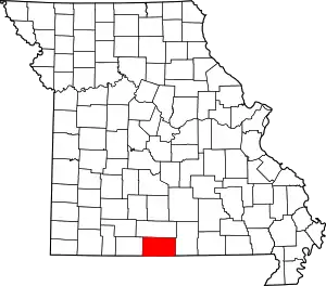
Prestonia is an unincorporated community in Ozark County, Missouri, United States.[1] The Prestonia site lies on a ridge above East Pidgeon Creek and is southwest of Howards Ridge. The Missouri-Arkansas border is approximately one mile to the south and Norfork Lake is about four miles to the east. Access is from Missouri Route J via county road J529.[2][3]
History
A post office called Prestonia was established in 1891, and remained in operation until 1913.[4] The community was named after one Mr. Preston, the proprietor of a local mill.[5]
References
- ↑ U.S. Geological Survey Geographic Names Information System: Prestonia, Missouri
- ↑ Udall Quadrangle, Missouri–Ozark County, 7.5 minute quad., USGS, 1968 (based on GNIS cords.)
- ↑ Missouri Atlas & Gazetteer, DeLorme, 1998, First edition, p. 63, ISBN 0-89933-224-2
- ↑ "Post Offices". Jim Forte Postal History. Retrieved November 27, 2016.
- ↑ "Ozark County Place Names, 1928–1945". The State Historical Society of Missouri. Archived from the original on June 24, 2016. Retrieved November 27, 2016.
36°30′45″N 92°21′01″W / 36.51250°N 92.35028°W
This article is issued from Wikipedia. The text is licensed under Creative Commons - Attribution - Sharealike. Additional terms may apply for the media files.
