 |
|---|
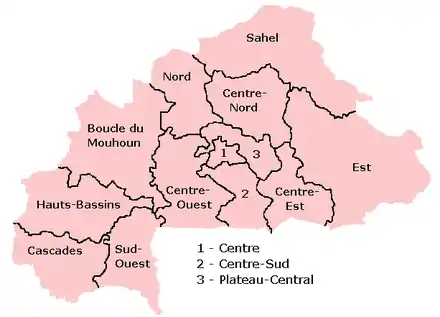
The regions of Burkina Faso are divided into 45 administrative provinces.[1][2] These 45 provinces are currently sub-divided into 351 departments or communes.[3]

Provinces of Burkina Faso with names
List of provinces by region

Provinces of Burkina Faso by number
Here is a list of the provinces, with their capitals in parentheses:
Central Burkina Faso
Centre Region
- Kadiogo (Ouagadougou) (#14 in map)
Centre-Nord Region
- Bam (Kongoussi) (#2 in map)
- Namentenga (Boulsa) (#26 in map)
- Sanmatenga (Kaya) (#34 in map)
Centre-Sud Region
- Bazèga (Kombissiri) (#4 in map)
- Nahouri (Pô) (#25 in map)
- Zoundwéogo (Manga) (#45 in map)
Plateau-Central Region
- Ganzourgou (Zorgho) (#9 in map)
- Kourwéogo (Boussé) (#21 in map)
- Oubritenga (Ziniaré) (#29 in map)
Eastern Burkina Faso
Centre-Est Region
- Boulgou (Tenkodogo) (#6 in map)
- Koulpélogo (Ouargaye) (#19 in map)
- Kouritenga (Koupéla) (#20 in map)
Est Region
- Gnagna (Bogandé) (#10 in map)
- Gourma (Fada N'gourma) (#11 in map)
- Komondjari (Gayéri) (#16 in map)
- Kompienga (Pama) (#17 in map)
- Tapoa (Diapaga) (#39 in map)
Northern Burkina Faso
Nord Region
Sahel Region
Southern Burkina Faso
Cascades Region
Hauts-Bassins Region
- Houet (Bobo-Dioulasso) (#12 in map)
- Kénédougou (Orodara) (#15 in map)
- Tuy (Houndé) (#40 in map)
Sud-Ouest Region
Western Burkina Faso
Boucle du Mouhoun Region
Centre-Ouest Region
Populations of the 45 Provinces
 A clickable map of Burkina Faso exhibiting its 13 administrative regions. |
| Province | Population at 2006 Census [4] | Population at 2019 Census [5] |
|---|---|---|
| Balé | 213,423 | 297,367 |
| Bam | 275,191 | 473,955 |
| Banwa | 269,375 | 345,749 |
| Bazèga | 238,425 | 280,793 |
| Bougouriba | 101,479 | 153,606 |
| Boulgou | 543,570 | 736,559 |
| Boulkiemdé | 505,206 | 689,184 |
| Comoé | 407,528 | 632,695 |
| Ganzourgou | 319,380 | 481,794 |
| Gnagna | 408,669 | 675,897 |
| Gourma | 305,936 | 437,242 |
| Houet | 955,451 | 1,509,377 |
| Ioba | 192,321 | 265,876 |
| Kadiogo | 1,727,390 | 3,032,668 |
| Kénédougou | 285,695 | 399,836 |
| Komondjari | 79,507 | 105,584 |
| Kompienga | 75,867 | 117,672 |
| Kossi | 278,546 | 355,655 |
| Koulpélogo | 258,667 | 361,586 |
| Kouritenga | 329,779 | 479,930 |
| Kourwéogo | 138,217 | 181,202 |
| Léraba | 124,280 | 179,367 |
| Loroum | 142,853 | 198,178 |
| Mouhoun | 297,350 | 391,325 |
| Nahouri | 157,071 | 195,608 |
| Namentenga | 328,820 | 512,529 |
| Nayala | 163,433 | 223,090 |
| Noumbiel | 70,036 | 98,883 |
| Oubritenga | 238,775 | 314,514 |
| Oudalan | 195,964 | 158,146 |
| Passoré | 323,222 | 457,781 |
| Poni | 256,931 | 355,665 |
| Sanguié | 297,036 | 391,520 |
| Sanmatenga | 598,014 | 885,642 |
| Séno | 264,991 | 404,104 |
| Sissili | 208,409 | 336,972 |
| Soum | 347,335 | 363,633 |
| Sourou | 220,622 | 284,947 |
| Tapoa | 342,305 | 605,110 |
| Tuy | 228,458 | 329,162 |
| Yagha | 160,152 | 169,024 |
| Yatenga | 553,164 | 824,994 |
| Ziro | 175,915 | 241,663 |
| Zondoma | 166,557 | 239,955 |
| Zoundwéogo | 245,947 | 311,940 |
| Totals | 14,017,262 | 20,487,979 |
See also
References
- ↑ Benjamin Kambou. "Les 45 Provinces du BURKINA FASO" (PDF).
- ↑ "burkina" (PDF). UN.
- ↑ "MEMORANDUM SUR LA DETERMINATION DU NOMBRE DE SIEGES DES CONSEILLERS MUNICIPAUX PAR VILLAGES ET PAR SECTEURS DANS LE CADRE DES ELECTIONS LOCALES DU 02 DECEMBRE 2012" (PDF). Ouagadougou. 11 September 2012. Archived from the original (PDF) on 2016-12-31. Retrieved 10 March 2017.
- ↑ "Home". citypopulation.de.
- ↑ provisional, from www.citypopulation.de
External links
This article is issued from Wikipedia. The text is licensed under Creative Commons - Attribution - Sharealike. Additional terms may apply for the media files.
