Highway 188 | ||||
|---|---|---|---|---|
| Ruta 188 | ||||
| Route information | ||||
| Maintained by Puerto Rico DTPW | ||||
| Length | 5.8 km[1] (3.6 mi) | |||
| Major junctions | ||||
| South end | ||||
| North end | ||||
| Location | ||||
| Country | United States | |||
| Territory | Puerto Rico | |||
| Municipalities | Canóvanas, Loíza | |||
| Highway system | ||||
| ||||
| ||||

Puerto Rico Highway 188 (PR-188) is a north–south highway that travels from Canóvanas, Puerto Rico to Loíza.[2] It begins at its intersection with PR-3 and PR-9188 in Canóvanas and ends at its junction with PR-187 near downtown Loíza.[3]
Major intersections
| Municipality | Location | km[1] | mi | Destinations | Notes |
|---|---|---|---|---|---|
| Canóvanas | Canóvanas | 0.0 | 0.0 | Southern terminus of PR-188 and northern terminus of PR-9188; PR-66 exit 14 | |
| Loíza | Loíza barrio-pueblo | 5.8 | 3.6 | Eastern terminus of PR-188 | |
| 1.000 mi = 1.609 km; 1.000 km = 0.621 mi | |||||
Related route
Highway 9188 | |
|---|---|
| Location | Canóvanas |
| Length | 1.1 km[4] (0.68 mi) |
Puerto Rico Highway 9188 (PR-9188) is a connector that branches off from its intersection with PR-3 and PR-188, and ends at PR-66.[5] The entire route is located in Canóvanas, Canóvanas.
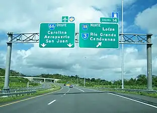
 PR-9188 north at PR-3 and PR-188 intersection in Canóvanas
| km[4] | mi | Destinations | Notes | ||
|---|---|---|---|---|---|
| 1.1 | 0.68 | Trumpet interchange; southern terminus of PR-9188; PR-66 exit 14 | |||
| 0.0 | 0.0 | Northern terminus of PR-9188 and southern terminus of PR-188; El Yunque National Forest access is via PR-3 east | |||
| 1.000 mi = 1.609 km; 1.000 km = 0.621 mi | |||||
See also
References
- 1 2 Google (2 March 2020). "PR-188" (Map). Google Maps. Google. Retrieved 2 March 2020.
- ↑ National Geographic Maps (2011). Puerto Rico (Map). 1:125,000. Adventure Map (Book 3107). Evergreen, Colorado: National Geographic Maps. ISBN 978-1566955188. OCLC 756511572.
- ↑ "Tránsito Promedio Diario (AADT)". Transit Data (Datos de Transito) (in Spanish). DTOP PR. p. 100. Archived from the original on 1 April 2019.
- 1 2 Google (5 April 2023). "PR-9188" (Map). Google Maps. Google. Retrieved 5 April 2023.
- ↑ "Mapa de Clasificación de Canóvanas" (PDF). Junta de Planificación (in Spanish). Retrieved 5 April 2023.
External links
 Media related to Puerto Rico Highway 188 and Puerto Rico Highway 9188 at Wikimedia Commons
This article is issued from Wikipedia. The text is licensed under Creative Commons - Attribution - Sharealike. Additional terms may apply for the media files.