.svg.png.webp) | ||||
|---|---|---|---|---|
| ||||
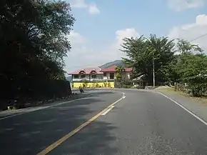
 Pugo–Rosario Road in Pugo, La Union | ||||
| Route information | ||||
| Maintained by Department of Public Works and Highways | ||||
| Length | 13 km (8.1 mi) Approximate length | |||
| Component highways |
| |||
| Major junctions | ||||
| North end | ||||
| South end | ||||
| Location | ||||
| Country | Philippines | |||
| Provinces | La Union | |||
| Towns | Pugo and Rosario | |||
| Highway system | ||||
| ||||
| ||||
The Pugo–Rosario Road is a major road in La Union that connects from MacArthur Highway in Rosario to the Aspiras–Palispis Highway in Pugo. It is the alternative route to Marcos Highway for motorists going to Pugo and Baguio.
The road forms part of National Route 209 (N209) of the Philippine highway network.[1]
Intersections
The entire route is located in La Union. Intersections are numbered by kilometer post, with the Rizal Park in Manila designated as Kilometer Zero.
| City/Municipality | km | mi | Destinations | Notes | ||
|---|---|---|---|---|---|---|
| Pugo | 227.9 | 141.6 | Northern terminus. Continues north into Pugo town proper as Municipal Road. | |||
| Rosario | 216.2 | 134.3 | Access to Rosario Town Proper. Northern end of the Rosario–Pugo Channelization Road segment. | |||
| 217.8 | 135.3 | Southern terminus. Roundabout intersection. | ||||
| 1.000 mi = 1.609 km; 1.000 km = 0.621 mi | ||||||
References
- ↑ "Road and Bridge Inventory". Department of Public Works and Highways. Retrieved June 12, 2023.
This article is issued from Wikipedia. The text is licensed under Creative Commons - Attribution - Sharealike. Additional terms may apply for the media files.