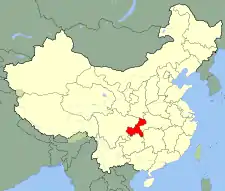
Qianjiang
黔江区 Kienkiang | |
|---|---|
 | |
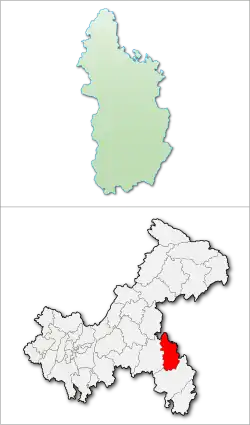 Qianjiang District in Chongqing | |
| Coordinates (Qianjiang government): 29°32′01″N 108°46′15″E / 29.5336°N 108.7707°E | |
| Country | People's Republic of China |
| Municipality | Chongqing |
| Seat | Chengxi Subdistrict |
| Area | |
| • Total | 2,397 km2 (925 sq mi) |
| Population (2009) | |
| • Total | 545,000 |
| • Density | 230/km2 (590/sq mi) |
| Time zone | UTC+8 (China Standard) |
Qianjiang District (simplified Chinese: 黔江区; traditional Chinese: 黔江區; pinyin: Qiánjiāng Qū), formerly Qianjiang Tujia and Miao Autonomous County, is a district (formerly an autonomous county), in the southeastern part of Chongqing, China, bordering Hubei province to the east and northeast. While it is governed as a district, in practice Qianjiang is its own city proper far removed from the urban centre of Chongqing. Qianjiang is nicknamed "The Throat of Sichuan and Hubei" (川鄂咽喉) because it sits on the intersection of Sichuan-Hubei and Sichuan-Hunan Roads.
Qianjiang District has a permanent population of 487,281, per the 2020 Chinese Census, the majority of which is ethnically Tujia.[1] The district is also home to large Han Chinese and Miao populations, which comprise about 30% and 15% of the district's population, respectively.[1]
History
According to the district government, humanoid activity in the region date back to approximately 600,000 years ago.[2]
The district government claims the area was incorporated into the Xia dynasty as Liang Prefecture (Chinese: 梁州).[2]
Later, the area would belong to the Baipu and the Ba state.[2]
During the Qin dynasty, the area was organized as Ba Commandery and Nan Commandery.[2] The area was home to a variety of different ethnic groups at the time.[2]
In 140 BCE, during the Western Han period, Fuling County was established under the Ba Commandery.[2] Fuling County's government was seated in present-day Yushan, and the county governed over much of present-day Chongqing and northeast Guizhou.[2] Circa 106 BCE, Liang Prefecture was reorganized as Yi Province, which now governed the area.[2]
In 201 CE, the area was reorganized as Fuling Commandery, which governed over four counties: Fuling County, Yongning County (Chinese: 永宁县), Hanjia County (Chinese: 汉葭县), and Danxing County (Chinese: 丹兴县).[2] Danxing County, which survived up through the Northern and Southern dynasties period, had its county seat in present-day Chengdong Subdistrict in Qianjiang District.[2] However, local administrative units often held little de facto power, as, for the next two centuries, local leaders of different ethnic groups raised local militias to promote their own interests.[2] In 565 CE, local ethnic leader Tian Sihe (Chinese: 田思鹤), effectively incorporated much of the land in the area into the Northern Zhou.[2] The Northern Zhou reorganized the area into a number of different zhou, including Feng Prefecture (which would shortly be changed to Qi Prefecture), Yong Prefecture, and Ting Prefecture.[2]
In 585 CE (during the Sui dynasty), Danxing County was reorganized as Shicheng County (石城县), which belonged to Yong Prefecture (庸州),[2] with the district seat at today's Ba Village of Baxiang County (坝乡县坝村). Due to the recent establishment of a number of other counties in the area, the territory governed by Shicheng County was relatively small, and the county was merged into Pengshui County (Chinese: 彭水县), which was governed by Qi Prefecture, in 607 CE.[2] Yong Prefecture was replaced by Badong Commandery (巴东郡).
Tang dynasty
In 618 CE, during the Tang dynasty, Shicheng County was re-established and became part of Qian Prefecture (黔州).[2] The county's seat was Wuci Town (无慈城).[2] Shortly after, Qian Prefecture was abolished, and the area was reorganized as Qianzhong Commandery (Chinese: 黔中郡), which governed over five counties: Pengshui County (same name as the previous iteration), Hongdu County (Chinese: 洪杜县), Yangshui County (Chinese: 洋水县), Yongning County (same name as the previous iteration), and Shicheng County.[2] In 630 CE, Shicheng's county seat moved back to Nanmuping.[2] In 742 CE,[2] Shicheng County was changed to Qianjiang County (Chinese: 黔江县),[2] and put under the jurisdiction of An Commandry (安郡).
Song dynasty and Yuan dynasty
From 960 to 1368 (Song and Yuan), Qianjiang at this time was "half-barbarian" (半没于夷) and dominated by the local rich bourgeois of the Gongs, Hus, Qins, and Xiangs (龚、胡、秦、向) according to the Qianjiang County Records (黔江县志) of the Qing Dynasty.
In 1228, during the Southern Song dynasty period, Qianjiang County was moved to the jurisdiction of Shaoqing Fu.[2]
In 1285 (late Yuan), Qianjiang was part of Ming Yuzhen's Daxia Empire.
Ming dynasty
In 1372, Qianjiang County was merged into nearby Pengshui County (Chinese: 彭水县).[2] In 1378, 1216 soldiers were dispatched here to guard the place. Qianjiang County was re-established in 1381.[2]
Qing dynasty
In early Qing, Qianjiang District was under Chongqing Subprefecture. In 1726, Qianjiang County was reorganized as a subprefecture (Chinese: 厅).[2] In 1734, the area was reorganized as Qianpeng Subprefecture, which governed Qianjiang County and Pengshui County.[2] This proved to be short-lived, as Qianpeng Subprefecture was abolished in 1736, and the area now fell under the jurisdiction of Youyang Subprefecture.[2]
Republic of China
In 1912, Qianjiang County was under Liuxiang Fangqu (刘湘防区). From 1927 to 1935, the county was directly governed by the Sichuan government.[2] In 1935, Qianjiang County was placed under the jurisdiction of the Eighth Administrative Region (第八行政督察区) of Sichuan Province, also known as Youyang Special District (酉阳专署).[2] The county seat was at Sanduo Town (三多镇).
People's Republic of China
On November 12, 1949, Qianjiang came under CPC control, and the People's Government was established on November 25, as part of Chuandong Administrative Special District (川东行政专区). The county seat changed to Lianhe Town (联合). On January 23, 1950,[2] the county was reorganized under Youyang Prefecture (Chinese: 酉阳专区),[2] which also administered Youyang and Xiushan Counties. In September 1952,[2] Youyang was merged into Fuling Prefecture, which later became a second Fuling Prefecture (same English translation, different Chinese characters).[2]
On November 14, 1983, the State Council approved changing Qianjiang County to Qianjiang Tujia and Miao Autonomous County (黔江土家苗族自治县),[2] reflecting the area's large Tujia and Miao population. The assembly was established November 13 of the following year.
On May 18, 1988, the State Council halved Fuling, reorganizing Qianjiang County, as well as four other counties (5 autonomous counties of Fuling's 10 counties), into a new prefecture: Qianjiang Prefecture (Chinese: 黔江地区).[2] The other four counties were:
- Shizhu Tujia Autonomous County (石柱土家族自治县)
- Pengshui Miao and Tujia Autonomous County (彭水苗族土家族自治县)
- Youyang Tujia and Miao Autonomous County (酉阳土家苗族自治县)
- Xiushan Tujia and Miao Autonomous County (秀山土家苗族自治县)
The prefecture officially began in November. At this time the area was 16,900 square kilometres (6,500 sq mi) with a population of 2,700,000.
Qianjiang County, along with Qianjiang District, was incorporated into Chongqing Municipality in 1997. In 1998, the prefecture was changed to the Qianjiang Development Area (Chinese: 黔江开发区),[2] which governs Shizhu, Xiushan, Qianjiang County, Pengshui and Youyang on behalf of Chongqing. On May 22, 1998 (implemented June 2000), Qianjiang Development Area and Qianjiang Autonomous County were abolished. In June 2000, Qianjiang Autonomous County and the Qianjiang Development Area were abolished, and became Qianjing District, directly administered by Chongqing.[2] Shizhu, Xiushan, Pengshui and Youyang remain autonomous counties, and are governed by Chonqging directly as well. Prior to becoming a district, Qianjiang had governed 5 towns, 45 townships, 8 neighborhood committees, and 517 village committees. Many townships were abolished, the only abolished town was Lianhe (联合), the old county seat now separated into sub-districts.
As of 2001, the district contained 3 sub-districts, 12 townships, 15 towns, and 489 village committees.
Administrative divisions
Currently, Qianjiang District administers 6 subdistricts, 15 towns, and 9 townships.[3]
| Name | Chinese (S)[3] | Hanyu Pinyin | Population (2010)[4] | Area (km2) |
|---|---|---|---|---|
| Chengdong Subdistrict | 城东街道 | Chéngdōng Jiēdào | 71,304 | 50 |
| Chengnan Subdistrict | 城南街道 | Chéngnán Jiēdào | 33,844 | 70 |
| Chengxi Subdistrict | 城西街道 | Chéngxī Jiēdào | 38,579 | 89.734 |
| Zhengyang Subdistrict | 正阳街道 | Zhèngyáng Jiēdào | 12,998 | 43.89 |
| Zhoubai Subdistrict | 舟白街道 | Zhōubái Jiēdào | 25,147 | 85.13 |
| Fengjia Subdistrict | 冯家街道 | Féngjiā Jiēdào | 21,810 | 51 |
| Apengjiang town | 阿蓬江镇 | Āpéngjiāng Zhèn | 18,596 | 174 |
| Shihui town | 石会镇 | Shíhuì Zhèn | 15,205 | 128 |
| Heixi town | 黑溪镇 | Hēixī Zhèn | 14,810 | 94 |
| Huangxi town | 黄溪镇 | Huángxī Zhèn | 9,862 | 70 |
| Lishui town | 黎水镇 | Líshuǐ Zhèn | 8,896 | 82 |
| Jinxi town | 金溪镇 | Jīnxī Zhèn | 8,940 | 42 |
| Mala town | 马喇镇 | Mǎlǎ Zhèn | 11,813 | 91 |
| Zhuoshui town | 濯水镇 | Zhuóshuǐ Zhèn | 20,386 | 105 |
| Shijia town | 石家镇 | Shíjiā Zhèn | 9,629 | 104 |
| Echi town | 鹅池镇 | Échí Zhèn | 8,581 | 73.2 |
| Xiaonanhai town | 小南海镇 | Xiǎonánhǎi Zhèn | 6,662 | 115 |
| Lin'e town | 邻鄂镇 | Lín'è Zhèn | 9,942 | 50 |
| Baishi town | 白石镇 | Báishí Zhèn | 11,706 | 95 |
| Zhongtang town | 中塘镇 | Zhōngtáng Zhèn | 11,324 | 80.47 |
| Shaba town | 沙坝镇 | Shābà Zhèn | 11,414 | 80 |
| Pengdong Township | 蓬东乡 | Péngdōng Xiāng | 6,066 | 34.9 |
| Shanling Township | 杉岭乡 | Shānlǐng Xiāng | 6,753 | 54 |
| Taiji Township | 太极乡 | Tàijí Xiāng | 8,242 | 64 |
| Shuitian Township | 水田乡 | Shuǐtián Xiāng | 5,984 | 40 |
| Baitu Township | 白土乡 | Báitǔ Xiāng | 5,188 | 66 |
| Jindong Township | 金洞乡 | Jīndòng Xiāng | 7,070 | 96.33 |
| Wuli Township | 五里乡 | Wǔlǐ Xiāng | 8,010 | 50 |
| Shuishi Township | 水市乡 | Shuǐshì Xiāng | 9,170 | 103 |
| Xinhua Township | 新华乡 | Xīnhuá Xiāng | 7,081 | 76 |
Climate
| Climate data for Qianjiang (1991–2014 normals, extremes 1981–2010) | |||||||||||||
|---|---|---|---|---|---|---|---|---|---|---|---|---|---|
| Month | Jan | Feb | Mar | Apr | May | Jun | Jul | Aug | Sep | Oct | Nov | Dec | Year |
| Record high °C (°F) | 21.2 (70.2) |
27.6 (81.7) |
31.6 (88.9) |
34.3 (93.7) |
35.1 (95.2) |
37.2 (99.0) |
38.4 (101.1) |
39.5 (103.1) |
36.6 (97.9) |
33.6 (92.5) |
27.0 (80.6) |
19.8 (67.6) |
39.5 (103.1) |
| Mean daily maximum °C (°F) | 8.2 (46.8) |
10.7 (51.3) |
15.4 (59.7) |
21.3 (70.3) |
25.3 (77.5) |
28.3 (82.9) |
31.2 (88.2) |
31.4 (88.5) |
27.1 (80.8) |
21.0 (69.8) |
16.0 (60.8) |
10.2 (50.4) |
20.5 (68.9) |
| Daily mean °C (°F) | 4.8 (40.6) |
7.0 (44.6) |
10.8 (51.4) |
16.0 (60.8) |
20.1 (68.2) |
23.5 (74.3) |
26.1 (79.0) |
25.8 (78.4) |
22.0 (71.6) |
16.6 (61.9) |
11.8 (53.2) |
6.7 (44.1) |
15.9 (60.7) |
| Mean daily minimum °C (°F) | 2.5 (36.5) |
4.5 (40.1) |
7.7 (45.9) |
12.5 (54.5) |
16.6 (61.9) |
20.1 (68.2) |
22.6 (72.7) |
22.0 (71.6) |
18.6 (65.5) |
13.8 (56.8) |
9.2 (48.6) |
4.3 (39.7) |
12.9 (55.2) |
| Record low °C (°F) | −4.0 (24.8) |
−4.2 (24.4) |
−2.2 (28.0) |
3.0 (37.4) |
8.5 (47.3) |
12.9 (55.2) |
15.7 (60.3) |
14.7 (58.5) |
10.8 (51.4) |
3.6 (38.5) |
−0.9 (30.4) |
−4.0 (24.8) |
−4.2 (24.4) |
| Average precipitation mm (inches) | 21.7 (0.85) |
32.6 (1.28) |
49.8 (1.96) |
115.2 (4.54) |
169.9 (6.69) |
155.4 (6.12) |
163.0 (6.42) |
165.7 (6.52) |
103.9 (4.09) |
103.6 (4.08) |
58.1 (2.29) |
19.7 (0.78) |
1,158.6 (45.62) |
| Average precipitation days (≥ 0.1 mm) | 10.6 | 10.7 | 12.3 | 15.5 | 17.5 | 15.8 | 14.0 | 13.5 | 10.7 | 14.1 | 11.4 | 9.6 | 155.7 |
| Average snowy days | 5.3 | 2.8 | 0.8 | 0 | 0 | 0 | 0 | 0 | 0 | 0 | 0.2 | 1.5 | 10.6 |
| Average relative humidity (%) | 78 | 77 | 76 | 78 | 78 | 79 | 78 | 76 | 77 | 82 | 81 | 79 | 78 |
| Mean monthly sunshine hours | 39.9 | 39.1 | 69.2 | 90.0 | 104.9 | 105.0 | 157.5 | 176.7 | 121.0 | 77.9 | 63.1 | 47.8 | 1,092.1 |
| Percent possible sunshine | 12 | 12 | 19 | 23 | 25 | 25 | 37 | 44 | 33 | 22 | 20 | 15 | 24 |
| Source: China Meteorological Administration[5][6] | |||||||||||||
Demographics

According the 2020 Chinese Census, there are 487,281 permanent residents in the district, a 9.50% increase from the 2010 Chinese Census.[1] The 2020 Census reported 176,443 household units in the district, of which, 170,310 households are familial, and the other 6,133 are non-familial households.[1] 457,711 people in the district live in familial households, and 29,570 people live in non-familial households.[1]
Ethnic groups
As of 2020, 55.11% of Qianjiang District is ethnically Tujia, 29.27% is Han Chinese, 15.19% is Miao, and the remaining 0.43% belonging to 24 various other ethnic minorities.[1] From 2010 to 2020, the district's Han Chinese population grew by 20.04%, the Miao population grew by 6.39%, the Tujia population grew 4.80%, and the population belonging to other ethnic groups grew 459.79%.[1]
Transport
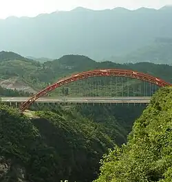
Qianjiang is located on the border between Chongqing Municipality and Hubei and Hunan provinces. The G65 Baotou–Maoming Expressway connects Qianjiang with the Chongqing city proper to the west and the city of Huaihua to the southeast. On G65, the drive to Chongqing city proper could take more than four hours. China National Highway 319 also runs through Qianjiang.
Qianjiang is served by the Qianjiang Wulingshan Airport, a regional airport with connections to Chongqing, Beijing, Guangzhou, Chengdu, and Kunming.
References
- 1 2 3 4 5 6 7 民族人口 [Ethnicity and Population] (in Chinese). Chongqing Qianjiang District People's Government. 2021-06-04. Archived from the original on 2021-10-12. Retrieved 2021-10-11.
- 1 2 3 4 5 6 7 8 9 10 11 12 13 14 15 16 17 18 19 20 21 22 23 24 25 26 27 28 29 30 31 32 33 34 35 36 37 历史沿革 [History] (in Chinese). Chongqing Qianjiang District People's Government. 2021-06-03. Archived from the original on 2021-10-12. Retrieved 2021-10-11.
- 1 2 2020年统计用区划代码(黔江区) [2020 Statistical Division Codes (Qianjiang District)] (in Chinese). National Bureau of Statistics of China. 2020. Archived from the original on 2021-10-12. Retrieved 2021-10-11.
- ↑ Census Office of the State Council of the People's Republic of China; Population and Employment Statistics Division of the National Bureau of Statistics of the People's Republic of China (2012). 中国2010人口普查分乡、镇、街道资料 (1 ed.). Beijing: China Statistics Print. ISBN 978-7-5037-6660-2.
- ↑ 中国气象数据网 – WeatherBk Data (in Simplified Chinese). China Meteorological Administration. Retrieved 28 April 2023.
- ↑ 中国气象数据网 (in Simplified Chinese). China Meteorological Administration. Retrieved 28 April 2023.