Quickville, Kansas | |
|---|---|
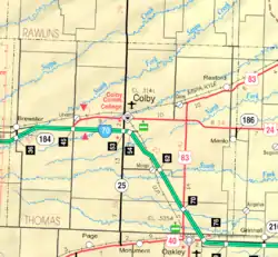 KDOT map of Thomas County (legend) | |
 Quickville  Quickville | |
| Coordinates: 39°31′41.4″N 101°16′49.3″W / 39.528167°N 101.280361°W | |
| Country | United States |
| State | Kansas |
| County | Thomas |
| Elevation | 3,307 ft (1,008 m) |
| Population | |
| • Total | 0 |
| Time zone | UTC-6 (CST) |
| • Summer (DST) | UTC-5 (CDT) |
| Area code | 785 |
| GNIS ID | 482662 [1] |
Quickville is a ghost town in Thomas County, Kansas, United States. It is farm ground with no remaining structures.
History
Quickville was platted on June 27, 1887, by the Thomas County Land and Townsite Co.[2][3]
It was issued a post office in 1880. The post office was discontinued in 1909.[4]
References
- ↑ "Quickville, Kansas", Geographic Names Information System, United States Geological Survey, United States Department of the Interior
- ↑ The National Gazetteer of the United States of America--Kansas, 1984. U.S. Government Printing Office. 1985.
- ↑ "Thomas County Schools". Kansas Historical Society. Retrieved 2022-03-14.
- ↑ "Kansas Post Offices, 1828-1961". Kansas Historical Society. Retrieved 2018-01-05.
Further reading
External links
Municipalities and communities of Thomas County, Kansas, United States | ||
|---|---|---|
| Cities | 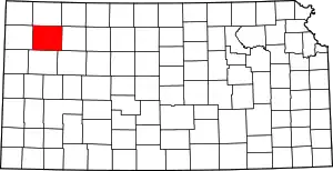 Map of Kansas highlighting Thomas County | |
| Unincorporated communities | ||
| Ghost towns | ||
| Footnotes | †This community is designated a Census-Designated Place (CDP) by the United States Census Bureau. ‡This community also has portions in an adjacent county or counties. | |
This article is issued from Wikipedia. The text is licensed under Creative Commons - Attribution - Sharealike. Additional terms may apply for the media files.