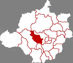
Shunping County
顺平县 | |
|---|---|
 Shunping in Baoding | |
.png.webp) Baoding in Hebei | |
| Coordinates: 38°50′13″N 115°08′06″E / 38.837°N 115.135°E | |
| Country | People's Republic of China |
| Province | Hebei |
| Prefecture-level city | Baoding |
| Time zone | UTC+8 (China Standard) |
| Website | www |
| Shunping County | |||||||||
|---|---|---|---|---|---|---|---|---|---|
 Peach blossoms in Shunping County | |||||||||
| Traditional Chinese | 順平縣 | ||||||||
| Simplified Chinese | 顺平县 | ||||||||
| |||||||||
| Former names | |||||||||
|---|---|---|---|---|---|---|---|---|---|
| Quni | |||||||||
| Chinese | 曲逆 | ||||||||
| |||||||||
Shunping County is a rural county in the west-central part of Hebei province, China.[1] It is under the administration of the prefecture-level city of Baoding and lies to the west of its urban core.
History
Under the Han, Shunping was known as Quni.[2] It was a base for Chen Xi's general Wang Huang (t 王黃, s 王黄, Wáng Huáng) in his short-lived rebellion and the site of the defeat and executions of Wang and Hou Chang (侯敞, Hóu Chǎng) by Guan Ying and other imperial forces in 196 BC.
It was renamed Shunping under Wang Mang's short-lived Xin Dynasty.
Administrative divisions
Towns:[1]
- Puyang (蒲阳镇), Gaoyupu (高于铺镇), Yaoshan (腰山镇)
Townships:[1]
- Pushang Township (蒲上乡), Baiyun Township (白云乡), Hekou Township (河口乡), Anyang Township (安阳乡), Taiyu Township (台鱼乡), Dabei Township (大悲乡), Shennan Township (神南乡)
Climate
| Climate data for Shunping (1991–2020 normals, extremes 1981–2010) | |||||||||||||
|---|---|---|---|---|---|---|---|---|---|---|---|---|---|
| Month | Jan | Feb | Mar | Apr | May | Jun | Jul | Aug | Sep | Oct | Nov | Dec | Year |
| Record high °C (°F) | 16.9 (62.4) |
23.0 (73.4) |
30.8 (87.4) |
33.0 (91.4) |
37.9 (100.2) |
40.7 (105.3) |
41.4 (106.5) |
35.9 (96.6) |
34.4 (93.9) |
31.9 (89.4) |
24.1 (75.4) |
19.4 (66.9) |
41.4 (106.5) |
| Mean daily maximum °C (°F) | 2.8 (37.0) |
6.8 (44.2) |
13.9 (57.0) |
21.2 (70.2) |
27.0 (80.6) |
31.3 (88.3) |
31.8 (89.2) |
30.2 (86.4) |
26.4 (79.5) |
19.9 (67.8) |
10.9 (51.6) |
4.2 (39.6) |
18.9 (66.0) |
| Daily mean °C (°F) | −3.5 (25.7) |
0.4 (32.7) |
7.6 (45.7) |
15.1 (59.2) |
21.0 (69.8) |
25.4 (77.7) |
26.9 (80.4) |
25.4 (77.7) |
20.4 (68.7) |
13.4 (56.1) |
4.9 (40.8) |
−1.5 (29.3) |
13.0 (55.3) |
| Mean daily minimum °C (°F) | −8.6 (16.5) |
−4.9 (23.2) |
1.5 (34.7) |
8.5 (47.3) |
14.3 (57.7) |
19.4 (66.9) |
22.4 (72.3) |
21.1 (70.0) |
15.3 (59.5) |
7.9 (46.2) |
0.0 (32.0) |
−6.1 (21.0) |
7.6 (45.6) |
| Record low °C (°F) | −20.2 (−4.4) |
−16.7 (1.9) |
−9.0 (15.8) |
−2.6 (27.3) |
4.0 (39.2) |
10.4 (50.7) |
16.3 (61.3) |
13.1 (55.6) |
5.4 (41.7) |
−3.2 (26.2) |
−14.6 (5.7) |
−22.0 (−7.6) |
−22.0 (−7.6) |
| Average precipitation mm (inches) | 2.4 (0.09) |
4.8 (0.19) |
8.6 (0.34) |
22.5 (0.89) |
31.9 (1.26) |
64.9 (2.56) |
168.4 (6.63) |
127.5 (5.02) |
49.7 (1.96) |
23.2 (0.91) |
12.1 (0.48) |
2.2 (0.09) |
518.2 (20.42) |
| Average precipitation days (≥ 0.1 mm) | 1.7 | 2.3 | 2.9 | 5.0 | 6.3 | 9.4 | 12.5 | 11.1 | 7.1 | 5.2 | 3.1 | 1.9 | 68.5 |
| Average snowy days | 2.3 | 2.3 | 1.1 | 0.2 | 0 | 0 | 0 | 0 | 0 | 0 | 1.7 | 2.3 | 9.9 |
| Average relative humidity (%) | 55 | 50 | 47 | 51 | 56 | 61 | 75 | 80 | 75 | 68 | 64 | 58 | 62 |
| Mean monthly sunshine hours | 169.3 | 171.5 | 215.5 | 236.6 | 251.8 | 209.2 | 172.9 | 188.1 | 195.4 | 186.4 | 160.9 | 165.4 | 2,323 |
| Percent possible sunshine | 56 | 56 | 58 | 59 | 57 | 47 | 39 | 45 | 53 | 55 | 54 | 57 | 53 |
| Source: China Meteorological Administration[3][4] | |||||||||||||
References
Citations
- 1 2 3 保定市-行政区划网
- ↑ Hung (2011), p. 202.
- ↑ 中国气象数据网 – WeatherBk Data (in Simplified Chinese). China Meteorological Administration. Retrieved 25 August 2023.
- ↑ 中国气象数据网 (in Simplified Chinese). China Meteorological Administration. Retrieved 25 August 2023.
Bibliography
Hung Hing-ming (2011), The Road to the Throne: How Liu Bang Founded China's Han Dynasty, New York: Algora Publishing, ISBN 9780875868387.
This article is issued from Wikipedia. The text is licensed under Creative Commons - Attribution - Sharealike. Additional terms may apply for the media files.