| Espíritu Santo River | |
|---|---|
 Río Espíritu Santo | |
| Native name | Río Espíritu Santo (Spanish) |
| Location | |
| Commonwealth | Puerto Rico |
| Municipality | Río Grande |
| Physical characteristics | |
| Source | |
| • coordinates | 18°24′41″N 65°48′13″W / 18.4113369°N 65.8034969°W[1] |
The Río Espíritu Santo (Spanish: Río Espíritu Santo) is a river of Río Grande, Puerto Rico.[2][3][4] Espíritu Santo River begins at the highest elevation of the El Yunque National Forest.[5]
Description
Río Espíritu Santo is located in the Río Espíritu Santo Natural Reserve. It is operated by the Puerto Rico Department of Natural and Environmental Resources.[6]
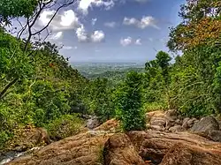
The river is scenic with pools, waterfalls, and rapids within extensive tropical forest.[7][2]
The Río Espíritu Santo Observation Point is located on PR-186 km 18.9.[2]
Gallery

Lambert conformal conic projection map showing area of Río Espíritu Santo
See also
References
- ↑ U.S. Geological Survey Geographic Names Information System: Río Espíritu Santo
- 1 2 3 "Río Espíritu Santo Observation Point". El Yunque National Forest. Archived from the original on 2020-10-24. Retrieved 2022-10-17.
- ↑ Suarez, Victor. "Rios de Puerto Rico" (in Spanish). Archived from the original (PDF) on October 23, 2008.
- ↑ "Jacksonville District Navigable Waters Lists" (PDF). saj.usace.army.mil. SAJ. Archived (PDF) from the original on 2017-01-26. Retrieved 18 February 2019.
- ↑ Fodor's Travel Guides (30 September 2014). Fodor's Puerto Rico. Fodor's Travel. pp. 228–. ISBN 978-0-8041-4308-0. Archived from the original on 17 October 2022. Retrieved 23 February 2019.
- ↑ Tesoros naturales de Puerto Rico (in Spanish). Island Finance Corporation. 1996. pp. 28–29.
- ↑ "Puerto Rico - Rivers (U.S. National Park Service)". www.nps.gov.
External links
- USGS Hydrologic Unit Map – Caribbean Region (1974)
- Ground-Water Resources of Alluvial Valleys in Northeastern Puerto Rico - Rio Espfritu Santo to Rio Demajagua Area
- Rio Espfritu Santo Plate 1 USGS
This article is issued from Wikipedia. The text is licensed under Creative Commons - Attribution - Sharealike. Additional terms may apply for the media files.