Radostín nad Oslavou | |
|---|---|
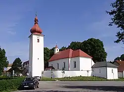 Church of Saint Bartholomew | |
 Flag  Coat of arms | |
 Radostín nad Oslavou Location in the Czech Republic | |
| Coordinates: 49°27′43″N 15°57′55″E / 49.46194°N 15.96528°E | |
| Country | |
| Region | Vysočina |
| District | Žďár nad Sázavou |
| First mentioned | 1390 |
| Area | |
| • Total | 15.48 km2 (5.98 sq mi) |
| Elevation | 526 m (1,726 ft) |
| Population (2023-01-01)[1] | |
| • Total | 934 |
| • Density | 60/km2 (160/sq mi) |
| Time zone | UTC+1 (CET) |
| • Summer (DST) | UTC+2 (CEST) |
| Postal code | 594 44 |
| Website | www |
Radostín nad Oslavou is a market town in Žďár nad Sázavou District in the Vysočina Region of the Czech Republic. It has about 900 inhabitants.
Administrative parts
The village of Zahradiště is an administrative part of Radostín nad Oslavou.
Geography
Radostín nad Oslavou is located about 11 kilometres (7 mi) south of Žďár nad Sázavou and 28 km (17 mi) east of Jihlava. It lies in the Křižanov Highlands. The highest point is at 618 m (2,028 ft) above sea level. The market town is situated on the right bank of the Oslava River.
History
The first written mention of Radostín nad Oslavou is from 1365, when it was already a market town. The village of Zahraditě was first mentioned in 1351. Among the most notable owners of Radostín were the Pernštejn family and House of Liechtenstein.[2]
Sights
The main landmark is the Church of Saint Bartholomew. It was built in the late Baroque style in the second half of the 18th century, but it has a Gothic core.[3][4]
References
- ↑ "Population of Municipalities – 1 January 2023". Czech Statistical Office. 2023-05-23.
- ↑ "Historie" (in Czech). Městys Radostín nad Oslavou. Retrieved 2023-09-11.
- ↑ "Kostel sv. Bartoloměje" (in Czech). National Heritage Institute. Retrieved 2023-09-11.
- ↑ "Radostín nad Oslavou, farní kostel sv. Bartoloměje" (in Czech). National Heritage Institute. Retrieved 2023-09-11.