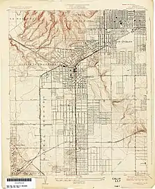

Rancho Aguaje de la Centinela was a 2,219-acre (8.98 km2) Mexican land grant in present-day Los Angeles County, California given in 1837 to Ygnacio Machado.[1] The name means "Sentinel of the Waters" in Spanish, and refers to the artesian water in the area exemplified by Centinela Springs. Rancho Aguaje de la Centinela included parts of present-day Westchester and Inglewood.[2][3]
History
Rancho Ajuaje de la Centinela, was once part of the Rancho Sausal Redondo, and Ygnacio Machado had encroached on the land claimed by Antonio Avila, and was awarded provisional title to this land at the same time that Antonio Avila received his land grant for the balance of the Rancho Sausal Redondo in 1837. In 1845, Machado traded the rancho to Bruno Avila, brother of Antonio Avila, for a small tract in the Pueblo of Los Angeles.[4]
With the cession of California to the United States following the Mexican–American War, the 1848 Treaty of Guadalupe Hidalgo provided that the land grants would be honored. As required by the Land Act of 1851, a claim for Rancho Aguaje de la Centinela was filed with the Public Land Commission in 1852,[5][6] and the grant was patented to Bruno Avila in 1872.[7]
Bruno Avila, unable to repay his debts, lost his property through foreclosure in 1857. According to Historic Spots in California, Hilliard P. Dorsey bought it at a sheriff's sale for about $1 a acre.[8] Then Dorsey was shot and killed by his father-in-law in what was determined to be a case of self-defense,[9][10] and Dorsey's widow sold it for 35 cents an acre to Francis I. Carpenter in 1859, who in turn sold it to Joseph Lancaster Brent.[8] Robert Burnett acquired the Rancho Ajuaje de la Centinela from Joseph Lancaster Brent in 1860, shortly thereafter Brent went off to become a brigadier general in the Confederate army.[8] In 1868, Burnett added the Rancho Sausal Redondo to his holdings, joining the two ranchos again. Burnett returned to Scotland in 1873, and leased the 25,000 acres (101 km2) of the combined ranchos to Catherine Freeman (wife of Daniel Freeman), with an agreement that she could eventually buy the ranchos outright. After Catherine's death in 1874, Daniel Freeman began the commercial development of the real estate. He became one of the directors of the Centinela Land Company, which started in 1874, with the purpose of developing commercially the Rancho Centinela. The venture failed, but Freeman was central in another undertaking, that of the Centinela-Inglewood Land Company, in 1887, to develop what would be known as the town of Inglewood.[11]


Marker and correction

The local chapter of the Native Daughters of the Golden West placed a marker mentioning Rancho Aguaje de la Centinela at the Theme Building of the Los Angeles International Airport in 1962.
The following letter appeared in the Los Angeles Times on Sept. 14, 1963.
- ERROR CITED IN AIRPORTS RANCHO MARKER
- I’m surprised that a bronze marker at Los Angeles International Airport could show wrong information. The marker bears the words: “Original Mexican grant to Ignacio Machado in 1844 known as Rancho Aguaje de Centinela.”
- No part of International Airport is within Rancho Centinela. All of the airport is within Rancho Sausal Redondo.
- The nearest part of Rancho Centinela is 3700 ft from airport property.
- I hope the wrong marker was changed. I like my history to be facts not fiction.
- David I. Worsfold, Palms
Related locations
- Centinela Springs. Bubbling springs once flowed here.[13]
- Centinela Adobe is an adobe house constructed in 1834 by Ygnacio Machado.[14]
- Centinela Creek, a tributary of Ballona Creek
- Centinela Park in Inglewood now Edward Vincent Jr. Park
See also
References
- ↑ Ogden Hoffman, 1862, Reports of Land Cases Determined in the United States District Court for the Northern District of California, Numa Hubert, San Francisco
- ↑ Map of old Spanish and Mexican ranchos in Los Angeles County
- ↑ U.S. Geological Survey Geographic Names Information System: Rancho Aguaje de la Centinela
- ↑ Hoover, Mildred B.; Rensch, Hero; Rensch, Ethel; Abeloe, William N. (1966). Historic Spots in California. Stanford University Press. ISBN 978-0-8047-4482-9.
- ↑ United States. District Court (California : Southern District) Land Case 125 S
- ↑ Finding Aid to the Documents Pertaining to the Adjudication of Private Land Claims in California, circa 1852-1892
- ↑ Report of the Surveyor General 1844 - 1886 Archived 2013-03-20 at the Wayback Machine
- 1 2 3 Rensch, Hero Eugene; Rensch, Ethel Grace (1932). Historic Spots in California: The Southern Counties. Stanford University Press. pp. 78–79.
- ↑ "Atlanta weekly intelligencer. (Atlanta, Ga.) 185?-18??, October 28, 1858, Image 1 « Georgia Historic Newspapers". gahistoricnewspapers.galileo.usg.edu. Retrieved 2023-12-09.
- ↑ Historic Record Company, Los Angeles; Brackett, Frank Parkhurst (1920). History of Pomona Valley, California, with biographical sketches of the leading men and women of the valley who have been identified with its growth and development from the early days to the present . Allen County Public Library Genealogy Center. Los Angeles, Cal., Historic Record Company. pp. 84–87.
- ↑ "Family History, Freeman Family Papers, CSLA-21". Loyola Marymount University. Archived from the original on March 23, 2010. Retrieved 7 July 2009.
- ↑ "Centinela-Inglewood Land Company". csl.primo.exlibrisgroup.com. Retrieved 2023-12-01.
- ↑ "Centinela Springs". California State Parks Office of Historic Preservation. Retrieved 17 August 2016.
- ↑ Exterior view of an adobe at Rancho Aguaje de la Centinela, near Inglewood, ca.1930
