Relief Inlet
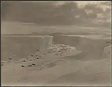
Relief Inlet (75°13′S 163°45′E / 75.217°S 163.750°E) is a narrow inlet at the southwest corner of Terra Nova Bay.[1] The feature is formed along a shear plane caused by differential ice movement near the coast of Victoria Land involving the north edge of Drygalski Ice Tongue and south extremities of the Nansen Ice Sheet.[2][3] So named by the South Magnetic Polar Party, led by T.W.E. David, of the British Antarctic Expedition, 1907–09, because, after almost giving up hope of rescue, the Nimrod picked up the party here.[1]
References
- 1 2 "Antarctica Detail". geonames.usgs.gov. Retrieved 2021-05-20.
- ↑ David, T. W. Edgeworth (1914). "Antarctica and Some of Its Problems". The Geographical Journal. 43 (6): 605–627. doi:10.2307/1779145. ISSN 0016-7398 – via JSTOR.
- ↑ Frezzotti, M.; Mabin, M.C.G (1994). "20th century behaviour of Drygalski Ice Tongue, Ross Sea, Antarctica". Annals of Glaciology. 20: 397–400. doi:10.3189/1994AoG20-1-397-400. ISSN 0260-3055.
![]() This article incorporates public domain material from "Relief Inlet". Geographic Names Information System. United States Geological Survey.
This article incorporates public domain material from "Relief Inlet". Geographic Names Information System. United States Geological Survey.
This article is issued from Wikipedia. The text is licensed under Creative Commons - Attribution - Sharealike. Additional terms may apply for the media files.