| West Lyn River | |
|---|---|
 Glen Lyn Gorge | |
| Location | |
| Country | England |
| County | Somerset |
| Physical characteristics | |
| Source | |
| • location | The Chains, Somerset, England |
| • coordinates | 51°10′36″N 3°38′40″W / 51.17667°N 3.64444°W |
| • elevation | 400 m (1,300 ft) |
| Mouth | Lynmouth |
• location | Devon, England |
• coordinates | 51°13′46″N 3°49′44″W / 51.22944°N 3.82889°W |
• elevation | 0 m (0 ft) |
| Basin features | |
| Tributaries | |
| • left | River West Lyn |
The West Lyn is a river in England which rises high in Exmoor, Somerset, and joins the East Lyn at Lynmouth in Devon.
The upper reaches have been designated as a Site of Special Scientific Interest, because of the geomorphological landforms created in the 1952 flood.[1]
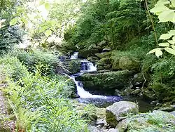
The lower reaches of the river towards Lynmouth, known as the Glen Lyn Gorge, is a tourist attraction including a museum about the local water cycle, the floods of 1952, and a small hydroelectric plant.
Water is piped from the river to generate hydroelectric power for the Lynton and Lynmouth Cliff Railway, which is a water-balance funicular railway.
References
- ↑ "River Lyn SSSI citation sheet" (PDF). English Nature. Retrieved 26 May 2009.
This article is issued from Wikipedia. The text is licensed under Creative Commons - Attribution - Sharealike. Additional terms may apply for the media files.