Rosendaël | |
|---|---|
Part of Dunkirk | |
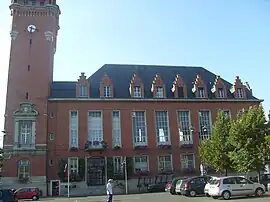 Town hall annex | |
 Coat of arms | |
Location of Rosendaël | |
 Rosendaël  Rosendaël | |
| Coordinates: 51°02′29″N 2°24′13″E / 51.0413°N 2.4037°E | |
| Country | France |
| Region | Hauts-de-France |
| Department | Nord |
| Arrondissement | Dunkirk |
| Canton | Dunkerque-2 |
| Commune | Dunkirk |
| Area 1 | 3.97 km2 (1.53 sq mi) |
| Population (1999) | 18,272 |
| • Density | 4,600/km2 (12,000/sq mi) |
| Time zone | UTC+01:00 (CET) |
| • Summer (DST) | UTC+02:00 (CEST) |
| Postal code | 59240 |
| 1 French Land Register data, which excludes lakes, ponds, glaciers > 1 km2 (0.386 sq mi or 247 acres) and river estuaries. | |
Rosendaël (French pronunciation: [ʁozɑ̃dal]; Dutch: Rozendaal; West Flemish: Rozendoale; French Flemish: Roozendaele; meaning "rose valley") is a former commune in the Nord department in northern France. In 1971 it was merged into Dunkirk.[1] It currently has 18,272 inhabitants (an almost ten-fold increase since 1825) in an area of 3.97 km2.
Heraldry
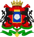
_Nord-France.svg.png.webp) Arms of Rosendaël |
The arms of Rosendaël are blazoned : D'azur à la Rose d'Argent
|
Rosendaël also has its own flag, Barry of 6 gules and vert
- Grandes armes de Rosendaël.
_Nord-France.svg.png.webp) Flag of Rosendaël
Flag of Rosendaël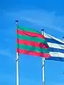 Flag of Rosendaëlsur dam
See also
- Communes of the Nord department
- Roosendael Abbey in Antwerp, Belgium
- Roosendaal, city in North Brabant, Netherlands
- Rozendaal, South Holland, town in the Netherlands
- Rozendaal, town in Gelderland, Netherlands
- Jack Rosendaal (born 1973), Dutch decathlete
References
- ↑ Des villages de Cassini aux communes d'aujourd'hui: Commune data sheet Rosendaël, EHESS (in French).
This article is issued from Wikipedia. The text is licensed under Creative Commons - Attribution - Sharealike. Additional terms may apply for the media files.