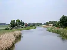
The Rotte is a river in the Rhine-Maas-delta in the Netherlands. The Rotte is the eponym of the city of Rotterdam: the city was founded in the 13th century when a dam was built along the river.
Etymology
The river was originally named Rotta, from rot, meaning "muddy" and aa meaning "water," thus "muddy water."
Geography
It rises in Moerkapelle in the so-called Green Heart. It used to drain the Zuidplas lake until it was reclaimed in 1840.
It flows past Bleiswijk and Bergschenhoek; and then the village of Hillegersberg, which was built on a sand dune and was one of the few places in the marsh land that could be permanently settled before the dikes were constructed. In the churchyard there are the ruins of a 13th century castle whose origins probably date back to the Roman Empire. Originally it flowed into the Nieuwe Maas in Rotterdam; however, the lower reach of the river was dammed off and the water now flows to the Nieuwe Maas via several man-made canals.

On the outskirts of Rotterdam, the Rotte merges with the Crooswijksesingel. Here, there is an old factory building of the Heineken brewery, which was brought here in the city due to the efforts of Lodewijk Pincoffs.
Inner Rotte
The Inner Rotte, that is, the part of the river in the Rotterdam city area, had to give way in 1869-1871 to the construction of the "Luchtspoor", an elevated section of the railway line. The river water was diverted via the Stokvisverlaat, the Delftse Vaart and Vlasmarktsluis to the Leuvehaven. When the Luftwaffe bombed the city in 1940, this connection was also damaged. During the Second World War, city planner Willem Gerrit Witteveen created a new connection to Leuvehaven. After the war, the Rotte was no longer used for freight transport.
The construction of the East-West line of the Rotterdam Metro interrupted the direct connection between the Rotte and Nieuwe Maas. Since then, the river water flows through an underground channel to the Oostplein.
In 1993 the elevated section of the railroad was demolished; trains now use the "Willemspoor" tunnel. Plans were made to dredge the old river bed and fill it with water. These plans were never implemented. The Inner Rotte is now a wide avenue, where events such as markets can be held. The former dam was situated where today the Inner Rotte crosses the Hoogstraat ('High Street').
 Former Windmill "De Oorsprong" at the Rotte source
 The first meters of the Rotte from the perspective of the mill
 Rotte near Hollevoeterbrug
 The Rotte near Prins Alexander
 The Rotte near Rotterdam
References
- Eric van Hooydonk, Patrick Verhoeven: The Portable ports - Antwerp, Hamburg and Rotterdam, Pandora Press, Antwerpen, ISBN 90-5325-250-9, p. 340 ff.
External links
![]() Media related to Rotte at Wikimedia Commons
Media related to Rotte at Wikimedia Commons