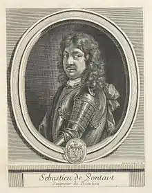
Sébastien Pontault de Beaulieu (1612–1674)[1] was an eminent French engineer, who is considered to be the first military topographer, or rather the inventor of that art, during the reign of Louis XIV.[2]
Biography
Pontault went into the army at the age of fifteen, and behaved with so much spirit at the siege of Rochelle, that the king gave him the post of commissary of artillery, even though he was so young. He was afterwards present at most of the battles and siege, which he has described, and did not quit a military life until the loss of an arm and other wounds, with the approach of old age, rendered retirement necessary.[3]
Pontault died on 10 August 1674.[4] From the death of this able drafts-man, there were few capable military topographers in France until the latter half of the 18th century.[5]
Works
It was Pontault's practice to follow the army, and construct upon the spot plans of the battles and sieges, with historical and perspective accompaniments. Many of his plans are in the
- Œvre de Belle-Belle,[5][lower-alpha 1]
but his most important work is entitled:
- Les glorieuses Conquêtes de Louis-le-Grand: ou Recueil, de Plans et Vues des places assiegeés, et de celles ou se_sont douneés des batailles, avec des Discours "The glorious victories of Louis the Great, produced from the drawings of the Chevalier de Beaulieu", 2 vols. folio.[5]

This work is one of the most magnificent of the kind, covers all the operations of war, from the battle of Rocroi, in 1643, to the taking of Namur, in 1692. Pontault died in 1674; but the work was completed to the above date at the expense of his niece, the widow of the sieur Des Roches. This edition is usually called the Grand Beaulieu, to distinguish it from one on a reduced scale, in oblong quarto, called the Petit Beaulieu, of which there are two series, one in three volumes, with views of the actions in the Netherlands; the other in four, which includes those of France.[5]
Pontault's other works include a comprehensive series of etchings—maps, landscapes, and town layouts—of Catalonia made in the years following the region's Reapers' War (itself a late element of the broader Thirty Years' War), from c. 1655-1661.
Notes
- ↑ Chalmers spells it Œvre de Belle-Belle but the modern spelling is Œuvre de Belle-Belle
- ↑ Barrucand, Marianne (2001). Arts et culture: une vision méridionale (in French). Presses Paris Sorbonne. p. 101. ISBN 9782840501411. Retrieved 19 June 2018.
- ↑ Chalmers 1816, pp. 150–151.
- ↑ Chalmers 1816, p. 151 cites Perrault 1701, pp. 43–44
- ↑ Perrault 1701, p. 44.
- 1 2 3 4 Chalmers 1816, p. 151.
References
- Perrault, Charles (1701), Les hommes illustres qui ont paru en France pendant ce siècle - avec leur portraits au naturel (in French), vol. 2 (2 vols. folio ed.), Paris, pp. 43–44
- Attribution
 This article incorporates text from this source, which is in the public domain: Chalmers, Alex. (1816), "Pontault, Sebastian Beaulieu de", The General Biographical Dictionary Containing an Historical and Critical Account of the Lives and Writings of the Most Eminent Persons; ... a New Ed. by, J. Nichols, pp. 150–151