Saint-Tite | |
|---|---|
 Catholic Church & presbytery, Notre-Dame Street | |
 Coat of arms | |
| Motto: L'union dans l'action | |
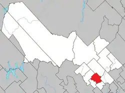
 Location within Mékinac RCM. | |
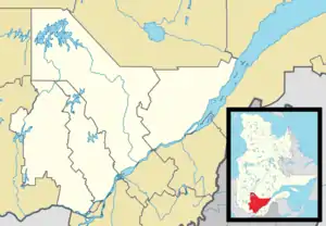
 Saint-Tite Location in central Quebec. | |
| Coordinates: 46°44′N 72°34′W / 46.733°N 72.567°W | |
| Country | |
| Province | |
| Region | Mauricie |
| RCM | Mékinac |
| Constituted | December 23, 1998 |
| Government | |
| • Mayor | Colin Lajoie |
| • Federal riding | Saint-Maurice—Champlain |
| • Prov. riding | Laviolette |
| Area | |
| • City | 92.90 km2 (35.87 sq mi) |
| • Land | 92.53 km2 (35.73 sq mi) |
| • Urban | 2.58 km2 (1.00 sq mi) |
| Population (2011)[1] | |
| • City | 3,880 |
| • Density | 41.9/km2 (109/sq mi) |
| • Urban | 2,306 |
| • Urban density | 893.8/km2 (2,315/sq mi) |
| • Pop 2006-2011 | |
| • Dwellings | 2,155 |
| Time zone | UTC−5 (EST) |
| • Summer (DST) | UTC−4 (EDT) |
| Postal code(s) | |
| Area code(s) | 418 and 581 |
| Highways | |
| Website | www |
Saint-Tite is a Canadian city located at the foothills of the Laurentians, between Grandes-Piles and Saint-Adelphe, in the Mauricie RCM of Mékinac. A large body of water, Lake Pierre-Paul, bathes the northeastern part of the territory.[2]' [3]
History
The first real inhabitants of the area were Indigenous peoples of the Americas – Algonquins, Innu and Métis – who lived near Lake Kapibouska.[3][2]
Indigenous peoples of the Americas. The small settlement of Saint-Juste-de Kapibouska took the name of Saint-Tite at the end of the 1850. Small Indigenous and Métis communities lived in makeshift camps whose permanence or duration depended on the availability of hunting, fishing, the quality of the soil to be cultivated, as many also did some gardening, and the fur trade. All French attempts to settle the Algonquins had failed.[4]
Mission. The Saint-Juste de Kapibouska mission was set up for the Aboriginal people living at Kapibouska Lake. At the beginning of the 19th century, missionaries visited the territory.
Pioneers. In the early 1830s, lumber yards were booming on the Rivière des Envies. The first settler of French-Canadian origin settled around 1833 in the area of the future city of Saint-Tite. Over time, several other pioneers were established.
Apart from the missionaries' visits, the settlers had to travel several kilometers to reach the church of St. Stanislaus. The first chapel-presbytery was built in the 1850s. The first resident priest arrived in 1859.
Easter water. From the beginning of colonization, it is likely that gathering Easter water was a common practice among members of the Christian community. In 1995, the first organized harvest and the blessing of Easter water took place at the Curé Boutet spring. The faithful get their feet wet, get dirty with mud, some fall on patches of ice. Safety and accessibility are the reasons for the construction of temporary sets. Today, throughout Quebec, this practice has become increasingly rare, becoming a social gathering or even a tourist activity.[5]
On Easter Sunday, we will have the celebration of Easter water at 4:30 a.m. before sunrise at the Curé spring at the end of Rue du Couvent. Afterwards, we will gather as a big family for a fraternal lunch at the Seniors' Club room around 5:30 am (Breakfast with baked beans, maple syrup and bread rolls, served by members of the Pastoral Council, free of charge).
Source: The parish leaflet of the Christian community of the parish of Saint-Tite, April 12, 1998[6].
Railway Fever 1878: The vast territory north of the St. Lawrence Plain, with its opening onto the immensity of the Canadian Shield, evokes grandiose dreams. In 1878, St. Laurence, Lower Laurentian & Saguenay obtained permission to build a track between Trois-Rivières and Saguenay-Lac-Saint-Jean via Saint-Tite[7].
Note: Kapibouska: of Algonquian origin, this name means "place of camp where there are reeds", kapi, "place of camp", baska or bouska "rushes", "reeds".[3]
Toponymy
The name of the parish of Saint-Tite is attested in 1859 and was established thanks to the canonical and civil erection that occurred in 1863 following its detachment from Sainte-Anne-de-la-Pérade and Saint-Stanislas de-la-Rivière-des-Envies. The post office, opened in 1859, and the parish municipality, established in 1863, took over the parish name that celebrates a companion of St. Paul the Apostle, who converted him in the first century by entrusting him with the task of organizing the Church of Ephesus.[2]
Transports
Highway 153 connects Saint-Tite to Shawinigan and Lac-aux-Sables, and Highway 159 to Saint-Roch-de-Mékinac and Sainte-Anne-de-la-Pérade. Saint-Tite is also served by the Via Rail Canada passenger train service, the Saint-Tite station (station platform) is located at 310 Marchildon Street.[8]
Geography
The city is crossed by the Rivière des Envies, a tributary of the Batiscan River. Rivière des Envies has its source at Lake Traverse in Sainte-Thècle and enters at the northern part (in "Grand marais" sector) of the territory of Saint-Tite. It crosses the municipality through the city, then heads to Proulxville.[9]
Coat of arms
The coat of arms of the city was adopted in 1954 by the city council.[10]
The coat of arms of Saint-Tite is blazoned thus: Greek cross gules a chief azure point, flanked by a toothed wheel segment money dexter and a gear segment sinister gold, containing a skin tight leather gold dextral and sinistral spruce money, overcoming mountains of sand placed on a terrace or charged with a blue river.
Demographics
In the 2021 Census of Population conducted by Statistics Canada, Saint-Tite had a population of 3,672 living in 1,915 of its 2,271 total private dwellings, a change of -0% from its 2016 population of 3,673. With a land area of 91.1 km2 (35.2 sq mi), it had a population density of 40.3/km2 (104.4/sq mi) in 2021.[11]
Population trend:[12]
| Year | Population | Variation (%) | Median age |
|---|---|---|---|
| 2011 | 3,880 | 52,4 years | |
| 2006 | 3,826 | ||
| 2001 | 3,845 | ||
| 1996 | 4,000 (Saint-Tite (city): 2,555; Saint-Tite (parish): 1,445) | ||
| 1991 | 4,093 (Saint-Tite (city): 2,654; Saint-Tite (parish): 1,448) |
Note: The two municipalities were merged in 1998.
According to the 2006 census:
- Less than 1% of the population is immigrant.
- 31% of the population over 15 years has no diploma.
- 7% of the population over 15 years has a degree of higher education.
- 60.2% of the population of Saint-Tite is urban. The urban area of Saint-Tite has a population of 2,306 and an area of 2.58 km2 in 2006, or a density of 893.8 inhabitants/km2.
- Private dwellings occupied by usual residents in 2011: 1846 (total dwellings: 2155)
Mother language of Saint-Tite's citizens:
Almost all of the population speaks French as a mother tongue:
- 16.2% of the population masters both official languages of Canada.
- French as first language: 98.6%
- English as first language: 0%
- English and French as first language: 0.3%
- Other as first language: 1.1%
Western Festival
The city of Saint-Tite is particularly known for the Festival Western de Saint-Tite, which takes place for 10 days in September every year. The Festival Western de Saint-Tite was developed from a rodeo inaugurated in 1967 to promote the leather industry. The Festival Western de Saint-Tite is the largest Western attraction in Eastern Canada. This festival of Eastern style, under the epithet Western, has an international reputation. The festival's success has led to the remodeling of some of the town's infrastructures to resemble a western frontier town of the late nineteenth or early twentieth centuries.
Since 1999, the Rodeo of Festival Western de Saint-Tite is awarded as the "Best outdoor rodeo in Americas". The festival features a variety of activities that take place at a rate of horsemen and the sound of country music and in Eastern decor: competition, conference, parade, tasting, demonstrations, exhibitions, shows, etc... The horsemen and women can participate in various tests of skill on the Monte horse or wild bull (with or without a saddle). They can participate in speed events, such as steer socket, or skill tests, such as the race between barrels.
During the 10 days of the Festival, several events take place in the various marquees erected around the city or at the Country Club Desjardins, a site that looks like a typical western town. The festival is marked by a country western character. The "Galaxie Rising Star Award" awarded at the Festival contributes to the development of musical talent in the country western area.
Culture
- Saint-Tite is an important part of the novel Les Filles de Caleb (Caleb's daughters), written by novelist Arlette Cousture. The backstory of this novel is based on the life of Émilie Bordeleau, a country school teacher who taught and lived with her children in schools in the area.
Notable people
- Julie Boulet, politician, member of the Liberal Party of Quebec.
- Gratien Gélinas (1909-1999), playwright and actor.
Photos
- Saint-Tite, Watercourses, Lake, Spring
 Envies River, Reinforced concrete girder bridge P-03956,[13] on Le Bourdais Steet, (Route 153)
 Pierre-Paul Lake, Chemin de l'Ìle
 Rivière Mékinac du Nord from bridge P-03959,steel-wood, under embankment (1982),[13] rang Haut-du-Lac Nord
 Le Bourdais River, from Bridge P-0363,reinforced concrete gantry, under embankment (1948),[13] route 359, Rang du Haut-du-Lac-Nord
 South Mékinac River the Laurentians, the river, from the bridge P-03952, Reinforced concrete frame, under embankment,[13] Quebec Route 359
 Barbier Spring[14] (Vernacular name, Notre-Dame Street, 2023
- Gathering Easter water
 Curé Boutet spring (Common name), rue du Couvent[5]
 Curé Boutet spring, rue du Couvent
 Curé Boutet spring, rue du Couvent
 Breakfast with baked beans, maple syrup and bread rolls, served by members of the Pastoral Council, free of charge, St-Joseph blvd
 Source du Barbier[14] (vernacular name), Notre-Dame Street, 2012
 Source du Barbier (vernacular name), Notre-Dame Street, 2012
- City's heart
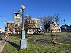
 Catholic Church sign on Notre-Dame Street, corner Saint-Paul
 Saint-Paul Street, Catholic Church on Notre-Dame Street
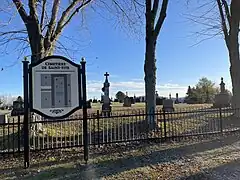
 Catholic Parish Cemetery sign, Saint-Joseph Blvd., (Quebec Route 159)
 Catholic Parish Cemetery, Saint-Joseph Blvd., (Quebec Route 159)
 Former Via Rail Canada Station Platform, rue Marchildon
See also
- Hydroclimatic Atlas of Southern Quebec, Ministère de l’Environnement, de la Lutte contre les changements climatiques, de la Faune et des Parcs
- Batiscanie, Quebec
- Rivière des Envies
- Batiscan River
- Pierre-Paul River
- North Mekinac River
- Lake Roberge (Grandes-Piles)
- Mékinac Regional County Municipality
References
- ↑ "Saint-Tite (Code 2435027) Census Profile". 2011 census. Government of Canada - Statistics Canada.
- 1 2 3 "Saint-Tite". Commission de toponymie Quebec (in French). Government of Quebec. 1999-02-05. Retrieved 2023-11-13.
- 1 2 3 Sylvie LeBel (2005). "Three aspects of the coexistence of the Native and Canadian populations in Mauricie 1870-1910" (PDF) (in French). Recherches amérindiennes au Québec. Retrieved 2023-11-13.
- ↑ Hardy, René (2010). "Tavibois 1951-2009" (pdf) (in French). Les éditions du Septentrion. pp. 13 of 22. Retrieved 2023-11-13.
- 1 2 "Discovering Easter Water in the 1980s" (in French). Radio Canada Society. 18 April 2019. Retrieved 2023-11-18.
Beliefs and Religions
- ↑ "Weekly Planner & Parish Leaflet" (in French). Lithographie St-Paul Ltée. 2023. Retrieved 2023-11-21.
To find out the latest news from the parish
- 1 2 René Verrette (1998). "Between dream and reality: the establishment of the Mauritian railway" (PDF). Erudit (in French). Les Éditions Cap-aux-Diamants inc. pp. 4 of 7. Retrieved 2023-11-17.
- 1 2 "Saint-Tite train station". Via Rail Canada. 2023. Retrieved 2023-11-17.
- ↑ Andrée-Ann Cloutier (29 September 2021). "Mékinac, Regional Wetlands and Bodies of Water Plan" (PDF) (in French). Société d'aménagement et de mise en valeur du bassin de la Batiscan (SAMBBA, OBV Batiscan-Champlain). pp. 31 of 67. Retrieved 2023-11-13.
- ↑ "Blason de la Ville de Saint-Tite (Coat of arms of Saint-Tite City)". Ville de Saint-Tite (City of Saint-Tite). Retrieved September 1, 2009.
- ↑ "Population and dwelling counts: Canada, provinces and territories, and census subdivisions (municipalities), Quebec". Statistics Canada. February 9, 2022. Retrieved August 29, 2022.
- ↑ Statistics Canada: 1996, 2001, 2006, 2011 census
- 1 2 3 4 Ministère des Transports et de la Mobilité durable (2023-11-11). "Inventory and Inspection of Structures" (in French). Government of Quebec. Retrieved 2023-11-12.
- 1 2 Bernard Lepage (2021-07-06). "René Brouillette: barber for 56 years" (in French). Hebdo Mékinac/Des Chenaux. Retrieved 2023-11-22.
Since July 1965
Further reading
- "Histoire de Saint-Tite 1833-1984 (History of Saint-Tite 1833-1984)" (second edition). Published in 1984 in French by Éditions Souvenance Inc and Historical Committee. 471 pages. Book Committee: Raymonde Rompré-LeBrun, Gisèle St-Amant-Matton, Gérard Brunelle, Marielle Brouillette, Louise Nobert-Béland, Pierre LeBrun, Jean-Pierre Paquet. Member of the "History of Saint-Tite" project sponsored by "Development Canada Community Project": Cécile Gélinas, Cécile Chaillé-Trépanier and Pierrette Délisle. Old photographs reproduced largely by Michel Pothier.(in French)
- "Répertoire des naissances et des baptêmes de Saint-Tite de Champlain 1859-1940 (Directory of births and baptisms of St. Tite de Champlain 1859-1940)", compiled by Jacques Delisle. Published in French.(in French)
- "Répertoire des mariages de la paroisse Saint-Tite de Champlain: 1859-1959 (Directory of marriages of the parish Saint-Tite de Champlain: 1859-1959)", Campagna, Dominique. Cap-de-la-Madeleine, s.n., 1968. 186 p.(in French)
- "Répertoire des décès et des sépultures de Saint-Tite de Champlain 1859-1940 (Directory death and burial of St. Tite de Champlain 1859-1940)", compiled by Jacques Delisle, 135 pages.(in French)
External links
- City of Saint-Tite of Champlain (Ville de Saint-Tite de Champlain): Official website (in French)