| Salmon Lake | |
|---|---|
 | |
 Salmon Lake | |
| Location | Seward Peninsula, Alaska |
| Coordinates | 64°54′10″N 165°00′31″W / 64.90278°N 165.00861°W |
| Type | lake |
| Primary inflows | Grand Central River |
| Primary outflows | Kruzgamepa River |
| Surface area | 1,800 acres (730 ha) |
| Surface elevation | 442 feet (135 m) |

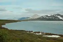
Salmon Lake (native name, Nahwazuk, meaning "salmon") is a natural lake on the Seward Peninsula in the U.S. state of Alaska. Situated 35 miles (56 km) north of Cape Nome, it drains into Port Clarence through Kruzgamepa River.[1] The lake lies at the foot of the Kigluaik Mountains at an elevation of about 442 feet (135 m). It has a water surface area of 1,800 acres (730 ha) and a drainage area of 81 square miles (210 km2). Its principal supply comes from Grand Central River, which enters it at its western end. A number of small streams also enter the lake from both the north and the south; Fox Creek and Jasper Creek are the most notable of these.[2] Efforts to dam the lake in order to provide power and water supply to mining endeavors occurred from 1906-1907, However these plans were later dropped due to disputes over land ownership and water rights.[3]
References
- ↑ Baker, Marcus (1906). Geographic dictionary of Alaska. Govt. Print. Off. pp. 289–. Retrieved 11 April 2013.
- ↑ Water-supply and Irrigation Papers of the United States Geological Survey (Public domain ed.). U.S. Government Printing Office. 1907. pp. 34–. Retrieved 11 April 2013.
- ↑ Moffit, Fred H. (1913). Nome and Grand Central Quadrangles. Department of the Interior United States Geological Survey (Report). Bulletin 533.