Sano
佐野市 | |
|---|---|
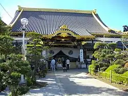
 Soshu-ji | |
 Flag  Seal | |
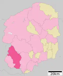
 Location of Sano in Tochigi Prefecture | |
 Sano | |
| Coordinates: 36°18′52.2″N 139°34′42″E / 36.314500°N 139.57833°E | |
| Country | Japan |
| Region | Kantō |
| Prefecture | Tochigi |
| Government | |
| • Mayor | Masahide Okabe (since April 2005) |
| Area | |
| • Total | 356.04 km2 (137.47 sq mi) |
| Population (August 2020) | |
| • Total | 117,669 |
| • Density | 330/km2 (860/sq mi) |
| Time zone | UTC+9 (Japan Standard Time) |
| Phone number | 0283-24-5111 |
| Address | 1, Takasagochō, Sano-shi, Tochigi-ken 327-0022 |
| Climate | Cfa |
| Website | Official website |
| Symbols | |
| Bird | Mandarin Duck |
| Flower | Katakuri |
| Tree | Pine |

Sano (佐野市, Sano-shi) is a city located in Tochigi Prefecture, Japan. As of 1 August 2020, the city had an estimated population of 117,669, in 52,066 households [1] and a population density of 330 persons per km2. The total area of the city is 356.04 square kilometres (137.47 sq mi). The city is known for its Outlet Mall, Sano Yakuyoke Daishi Temple, and its local variety of ramen, Sano Ramen. More recently, Sano has gained international recognition for being the home of cricket in Japan.
Geography
Sano is located in the northern Kantō plain, in southwestern Tochigi Prefecture, bordered by Gunma Prefecture to the west. The location river boundary connected by Tochigi.
Surrounding municipalities
Climate
Sano has a humid subtropical climate (Köppen Cfa) characterized by warm summers and cold winters with heavy snowfall. The average annual temperature in Sano is 14.5 °C (58.1 °F). The average annual rainfall is 1,258.0 mm (49.53 in) with July as the wettest month. The temperatures are highest on average in August, at around 26.3 °C (79.3 °F), and lowest in January, at around 3.2 °C (37.8 °F).[2]
| Climate data for Sano (1991−2020 normals, extremes 1978−present) | |||||||||||||
|---|---|---|---|---|---|---|---|---|---|---|---|---|---|
| Month | Jan | Feb | Mar | Apr | May | Jun | Jul | Aug | Sep | Oct | Nov | Dec | Year |
| Record high °C (°F) | 20.0 (68.0) |
23.1 (73.6) |
26.6 (79.9) |
31.2 (88.2) |
35.7 (96.3) |
38.4 (101.1) |
39.2 (102.6) |
39.8 (103.6) |
37.1 (98.8) |
34.3 (93.7) |
25.1 (77.2) |
25.2 (77.4) |
39.8 (103.6) |
| Mean daily maximum °C (°F) | 9.4 (48.9) |
10.3 (50.5) |
13.7 (56.7) |
19.3 (66.7) |
24.0 (75.2) |
26.6 (79.9) |
30.1 (86.2) |
31.5 (88.7) |
27.5 (81.5) |
21.9 (71.4) |
16.5 (61.7) |
11.6 (52.9) |
20.2 (68.4) |
| Daily mean °C (°F) | 3.2 (37.8) |
4.0 (39.2) |
7.6 (45.7) |
12.9 (55.2) |
17.9 (64.2) |
21.6 (70.9) |
25.2 (77.4) |
26.3 (79.3) |
22.5 (72.5) |
16.7 (62.1) |
10.5 (50.9) |
5.3 (41.5) |
14.5 (58.1) |
| Mean daily minimum °C (°F) | −2.5 (27.5) |
−1.8 (28.8) |
1.6 (34.9) |
6.8 (44.2) |
12.3 (54.1) |
17.4 (63.3) |
21.4 (70.5) |
22.3 (72.1) |
18.6 (65.5) |
12.3 (54.1) |
5.2 (41.4) |
−0.2 (31.6) |
9.5 (49.0) |
| Record low °C (°F) | −10.2 (13.6) |
−10.2 (13.6) |
−6.6 (20.1) |
−4.1 (24.6) |
1.0 (33.8) |
7.9 (46.2) |
14.2 (57.6) |
12.8 (55.0) |
7.5 (45.5) |
1.1 (34.0) |
−3.1 (26.4) |
−7.0 (19.4) |
−10.2 (13.6) |
| Average precipitation mm (inches) | 35.1 (1.38) |
33.4 (1.31) |
69.4 (2.73) |
90.5 (3.56) |
114.8 (4.52) |
145.2 (5.72) |
185.0 (7.28) |
162.2 (6.39) |
176.5 (6.95) |
160.6 (6.32) |
57.8 (2.28) |
31.0 (1.22) |
1,258 (49.53) |
| Average precipitation days (≥ 1.0 mm) | 3.7 | 4.7 | 8.5 | 9.4 | 10.7 | 13.3 | 13.9 | 11.3 | 11.8 | 10.0 | 6.3 | 3.9 | 107.5 |
| Mean monthly sunshine hours | 217.7 | 200.7 | 205.0 | 196.0 | 181.6 | 129.4 | 135.6 | 166.6 | 135.0 | 147.0 | 172.1 | 199.4 | 2,084 |
| Source 1: 理科年表 | |||||||||||||
| Source 2: Japan Meteorological Agency (Averages: 1981-2010; Peaks: 1978-present)[2][3] | |||||||||||||
Demographics
Per Japanese census data,[4] the population of Sano peaked around 1990 and has declined since.
| Year | Pop. | ±% |
|---|---|---|
| 1920 | 89,102 | — |
| 1930 | 92,570 | +3.9% |
| 1940 | 95,520 | +3.2% |
| 1950 | 120,541 | +26.2% |
| 1960 | 118,046 | −2.1% |
| 1970 | 118,083 | +0.0% |
| 1980 | 124,331 | +5.3% |
| 1990 | 128,276 | +3.2% |
| 2000 | 125,671 | −2.0% |
| 2010 | 121,259 | −3.5% |
| 2020 | 116,228 | −4.1% |
History
During the Edo period, Sano was a castle town and the seat of the daimyō of Sano Domain. Following the Meiji Restoration, the town of Sano was created within Aso District, Tochigi with the establishment of the modern municipalities system on April 1, 1889.Sano was elevated to city status on April 1, 1943, when it merged with the neighboring towns of Inubushi and Horigome and the villages of Sakai and Hatagawa. The city annexed the village of Inazuma (from Ashikaga District) on January 1, 1955, followed by the town of Akami(from Aso District) on April 1, 1955.
On February 28, 2005, Sano absorbed the towns of Kuzu and Tanuma (both from Aso District).
Government
Sano has a mayor-council form of government with a directly elected mayor and a unicameral city legislature of 26 members. Sano contributes three members to the Tochigi Prefectural Assembly. In terms of national politics, the city is part of Tochigi 5th district of the lower house of the Diet of Japan.
Economy
Agriculture and light manufacturing are mainstays of the local economy, with production of Kanpyō, turmeric and spinach being prominent local crops. The city is increasingly a commuter town for neighboring Utsunomiya.
Education
- Sano College
- Sano also has 26 public primary schools and 11 public middle schools operated by the city government. The city has three public high schools operated by the Tochigi Prefectural Board of Education. The prefecture also operates one middle school. There is also three private high schools.
Sports
Sano has become the headquarter of the Japan Cricket Association and has hosted a number of cricket matches between international teams. On 22 March 2016, it was announced that Sano would be home to the Sano International Cricket Ground, which will become Japan's first dedicated cricketing venue built for purpose which no longer has to compete with other sports for usage.[5][6][7]
Transportation
Railway
Highway
 Tōhoku Expressway – Sano-Fujioka Interchange, Sano Service Area and Smart Interchange
 Kita-Kantō Expressway – Izuruhara Parking Area, Sano-Tanuma Interchange
 National Route 50
 National Route 293
Bus
- Sano Shintoshi Bus Terminal
Local attractions
- house of Shōzō Tanaka
- site of Sano Castle
International relations
 Lancaster, Pennsylvania, United States[8]
 Quzhou, China, friendship city since 1997 [9]
Notable people from Sano
- Shōzō Tanaka, politician, social activist
- Takuro Ishii, professional baseball player
- Tatsuya Ozeki, professional baseball player
- Shunsuke Ishikawa, professional baseball player
- Kyogo Kawaguchi, singer-songwriter
References
- ↑ "Sano City official Statistics" (in Japanese). Japan.
- 1 2 "平年値(年ごとの値)". Japan Meteorological Agency. Retrieved August 10, 2012.
- ↑ "観測史上1~10位の値(年間を通じての値)". Japan Meteorological Agency. Retrieved August 10, 2012.
- ↑ Sano population statistics
- ↑ "International Cricket Ground to be built in Japan". Japan Cricket Association. 23 March 2016. Retrieved 1 September 2018.
- ↑ "JCA looking to build Japan's first international standard cricket ground". The Japan Times. 23 March 2016. Retrieved 1 September 2018.
- ↑ "Japan's international standard stadium gets green light". www.cricketworld.com. 23 March 2016. Retrieved 1 September 2018.
- ↑ Wallace, Brian (2009-05-04). "SDL scraps trip to Japan at request of Japanese officials concerned about the flu". Intelligencer Journal. Retrieved 2009-05-08.
- ↑ "QUZHOU traffic". Archived from the original on 2007-07-12. Retrieved 2015-09-20. Quzhou government information
External links
![]() Media related to Sano, Tochigi at Wikimedia Commons
Media related to Sano, Tochigi at Wikimedia Commons
- Official Website (in Japanese)