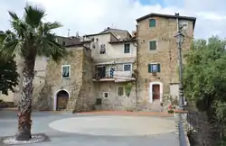
Sasso di Bordighera | |
|---|---|
 Village centre | |
 Sasso di Bordighera Location of Sasso di Bordighera in Italy | |
| Coordinates: 43°48′14.09″N 7°40′18.36″E / 43.8039139°N 7.6717667°E | |
| Country | |
| Region | |
| Province | Imperia (IM) |
| Comune | Bordighera |
| Elevation | 219 m (719 ft) |
| Population (2001)Istat - 14º Censimento generale della popolazione e delle abitazioni | |
| • Total | 212 |
| Time zone | UTC+1 (CET) |
| • Summer (DST) | UTC+2 (CEST) |
| Postal code | 18012 |
| Dialing code | (+39) 0184 |
Sasso di Bordighera is a frazione (and parish) of the municipality of Bordighera, in Liguria, northern Italy.
Geography

Sasso di Bordighera is located on a hilly ridge dividing the short valleys of Borghetto (west) and Sasso streams. ,[2]
History

Sasso di Bordighera was founded, following a local tradition, by the inhabitants of the neighbouring city of Taggia. The village is located on a rocky summit and its oldest part is made of tower-shaped houses. On the 21st of April 1686, the representants of eight villages, Camporosso, Vallebona, Vallecrosia, San Biagio della Cima, Sasso, Soldano, Borghetto San Nicolò and Bordighera had a meeting in order to build what they called "Magnifica Comunità degli Otto Luoghi", which can be translated as: "The magnificent community of the eight villages". Their goal was to gain independence from the nearby rival city of Ventimiglia.[3] At the beginning of the 20th century Sasso was linked to the coast with a new road which, starting from Bordighera, continues up to Seborga.[3]
Sasso di Bordighera was a separate comune (municipality) until 1928 when, with Borghetto San Nicolò (which also was an autonomous municipality) was joined with Bordighera.[4]
Bibliography
- Amati, Amato (1869). Dizionario corografico dell'Italia. Vol. 7. Milano: Vallardi. p. 280.
- Altavilla, Raffaele (1875). Il regno d'Italia: dizionario geografico - storico -statistico. Torino: A.F.Negro. p. 692.
References
- ↑ Limiti Amministrativi (Comunali, Provinciali, Regionali) sc. 1:25000 - ed. 2011; Regione Liguria, on-line map on geoportale.regione.liguria.it.
- ↑ Carta 1:25.00, Istituto Geografico Militare (on-line:www.pcn.minambiente.it)
- 1 2 Gandolfo, Andrea (2005). La provincia di Imperia: storia, arti, tradizioni. Vol. 1. Blu edizioni.
- ↑ "Comune ISTAT "008008 Bordighera (Imperia)"". www.elesh.it. Retrieved 2016-06-25.
![]() Media related to Sasso (Bordighera) at Wikimedia Commons
Media related to Sasso (Bordighera) at Wikimedia Commons