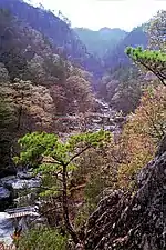
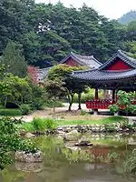
Scenic Sites (명승, 名勝) of South Korea are "Places of natural beauty with great historic, artistic or scenic values, which feature distinctive uniqueness and rarity originated from their formation processes" so designated by the Cultural Heritage Administration, an agency of the South Korean government.[1] The first was designated in 1979 and, as of 2020, 115 Scenic Sites have designated at a national level:[2]

Number Scenic Site Administrative Division Province Comments Image Coordinates
001Sogeumgang Mountain in Cheonghakdong, Myeongju
명주 청학동 소금강
溟州 靑鶴洞 小金剛
GangneungGangwon-doin Odaesan National Park37°52′04″N 128°37′47″E / 37.867787°N 128.629777°E / 37.867787; 128.629777 (Sogeumgang Mountain in Cheonghakdong, Myeongju)
002Haegeumgang Islets, Geoje
거제 해금강
巨濟 海金剛
GeojeGyeongsangnam-doin Hallyeohaesang National Park34°44′24″N 128°40′40″E / 34.740087°N 128.677874°E / 34.740087; 128.677874 (Haegeumgang Islets, Geoje)
003Gugyedeung Pebble Beach in Jeongdo-ri, Wando
완도 정도리 구계등
莞島 正道里 九階燈
Wando CountyJeollanam-do34°17′56″N 126°42′21″E / 34.298990°N 126.705819°E / 34.298990; 126.705819 (Gugyedeung Pebble Beach in Jeongdo-ri, Wando)
006Buryeongsagyegok Valley and Surroundings, Uljin
울진 불영사 계곡일원
蔚珍 佛影寺 溪谷 一圓
Uljin CountyGyeongsangbuk-do36°57′17″N 129°22′18″E / 36.954730°N 129.371704°E / 36.954730; 129.371704 (Buryeongsagyegok Valley and Surroundings, Uljin)
007Sangbaekdo and Habaekdo Islets, Yeosu
울진 불영사 계곡일원
蔚珍 佛影寺 溪谷 一圓
YeosuJeollanam-do34°01′42″N 127°19′07″E / 34.028298°N 127.318699°E / 34.028298; 127.318699 (Sangbaekdo and Habaekdo Islets, Yeosu)
008Dumujin Coast on Baengnyeongdo Island, Ongjin
옹진 백령도 두무진
甕津 白翎島 頭武津
Ongjin CountyIncheon37°56′59″N 124°37′54″E / 37.949672°N 124.631602°E / 37.949672; 124.631602 (Dumujin Coast on Baengnyeongdo Island, Ongjin)
009Sea-split Path, Jindo
진도의바닷길
珍島의 바닷길
Jindo CountyJeollanam-do34°22′29″N 126°08′15″E / 34.374856°N 126.137569°E / 34.374856; 126.137569 (Sea-split Path, Jindo)
010Samgaksan Mountain
삼각산
三角山
Gangbuk DistrictSeoulthe three peaks of Bukhansan37°38′53″N 126°58′16″E / 37.648082°N 126.971070°E / 37.648082; 126.971070 (Sea-split Path, Jindo)

See also

References

  1. "Heritage Classification". Cultural Heritage Administration. Retrieved 24 September 2020.
  2. "Scenic Sites". Cultural Heritage Administration. Retrieved 24 September 2020.
This article is issued from Wikipedia. The text is licensed under Creative Commons - Attribution - Sharealike. Additional terms may apply for the media files.