Sehore District | |
|---|---|
 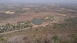 Top: Stupas in Saru Maru, Panguraria Bottom: View from Salkanpur Hill | |
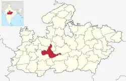 Location of Sehore district in Madhya Pradesh | |
| Coordinates (Sehore): 23°12′N 77°05′E / 23.200°N 77.083°E | |
| Country | India |
| State | Madhya Pradesh |
| Division | Bhopal |
| Headquarters | Sehore |
| Tehsils | 8: Sehore, Ashta, Budhni, Bhairunda, Rehti, Ichhawar, Shyampur, Jawar |
| Government | |
| • Lok Sabha constituencies | Bhopal |
| Area | |
| • Total | 6,578 km2 (2,540 sq mi) |
| Population (2011) | |
| • Total | 1,311,332 |
| • Density | 200/km2 (520/sq mi) |
| Demographics | |
| • Literacy | 70.06% |
| • Sex ratio | 918 |
| Time zone | UTC+05:30 (IST) |
| Major highways | Bhopal-Indore Highway |
| Website | sehore |
Sehore District is a district of Madhya Pradesh state in central India. The town of Sehore is the district headquarters. The district is part of Bhopal Division.
Geography
Sehore is 37 km from the state capital,Sehore is situated on the Western Railway line from Bhopal to Ratlam. It is surrounded by 7 districts: Bhopal, Raisen, Harda, Hoshangabad, Dewas, Shajapur and Rajgarh.The only river passing through the Sehore district is the Seevan and Parvati River.
Demographics
| Year | Pop. | ±% p.a. |
|---|---|---|
| 1901 | 234,308 | — |
| 1911 | 254,693 | +0.84% |
| 1921 | 242,362 | −0.50% |
| 1931 | 262,560 | +0.80% |
| 1941 | 278,270 | +0.58% |
| 1951 | 283,968 | +0.20% |
| 1961 | 381,286 | +2.99% |
| 1971 | 510,894 | +2.97% |
| 1981 | 657,381 | +2.55% |
| 1991 | 841,358 | +2.50% |
| 2001 | 1,078,912 | +2.52% |
| 2011 | 1,311,332 | +1.97% |
| source:[1] | ||
According to the 2011 census, Sehore District has a population of 1,311,332.[3][4][5] This gives it a ranking of 373 in India (out of a total of 640).[3] The district has a population density of 199 inhabitants per square kilometre (520/sq mi).[3] Its population growth rate over the decade 2001-2011 was 21.51%.[3] Sehore has a sex ratio of 918 females for every 1,000 males[3] and a literacy rate of 71.11%. 18.95% of the population lives in urban areas. Scheduled Castes and Scheduled Tribes make up 20.69% and 11.10% of the population respectively.[3]
According to the 2011 Census of India, 95.38% of the population in the district spoke Hindi, 2.31% Urdu and 1.46% Malvi as their first language.[6]
Government
- 156 Budhni
- 157 Ashta
- 158 Ichhawar
- 159 Sehore
There 4 asembly of sehore district that is govern by mla's
There is 8 tehsils in sehore district
Tourism
- Kolar dam:- Kolar Dam Located in Sehore district, is known for a tourist attraction as well as boating.
- Salkanpur:- Salkanpur is about 100 km from the city under Narmada area, at the height of 800 feet in Salkanpur, the temple of Maa Bijasan Devi is located where every year during the Navratri festival lacs number of devotees come for darshan and also ropeway is arranged for the devotees to reach the temple.[7]
Transportation
Sehore is located on Ujjain–Bhopal section it own Railway Station which connects it major city of madhya Pradesh
It's 37 km away from state capital Bhopal and welll connected with roads,
Nearby airport is Bhopal Airport ,
References
- ↑ "Table A-02 Decadal Variation in Population Since 1901: Madhya Pradesh" (PDF). census.gov.in. Registrar General and Census Commissioner of India.
- ↑ "Table C-01 Population By Religion: Madhya Pradesh". census.gov.in. Registrar General and Census Commissioner of India.
- 1 2 3 4 5 6 "District Census Handbook: Sehore" (PDF). Census of India. Registrar General and Census Commissioner of India. 2011.
- ↑ US Directorate of Intelligence. "Country Comparison:Population". Archived from the original on 13 June 2007. Retrieved 1 October 2011.
Mauritius 1,303,717 July 2011 est.
- ↑ "2010 Resident Population Data". U. S. Census Bureau. Retrieved 30 September 2011.
New Hampshire 1,316,470
- 1 2 "Table C-16 Population by Mother Tongue: Madhya Pradesh". censusindia.gov.in. Registrar General and Census Commissioner of India.
- ↑ https://sehore.nic.in/en/tourism/
External links
Places adjacent to Sehore district | |
|---|---|