Serengeti District
Wilaya ya Serengeti | |
|---|---|
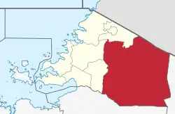 Serengeti District of Mara Region | |
| Coordinates: 01°50′S 034°40′E / 1.833°S 34.667°E | |
| Country | |
| Region | Mara Region |
| Population (2012) | |
| • Total | 249,420 |
| Website | http://serengetidc.go.tz/ |
Serengeti District is one of the seven districts of Mara Region of Tanzania. Its administrative centre is the town of Mugumu. It is home to part of the world-famous Serengeti National Park a UNESCO World Heritage Site and contains one of the western gates to the park.[1]
According to the 2012 Tanzania National Census, the population of Serengeti District was 249,420.[2]
Transport
There are no paved roads connecting Serengeti District with the rest of the country. The unpaved trunk road T17 from Musoma to Arusha passes through the district from west to east.[3]
Administrative subdivisions
As of 2012, Serengeti District was administratively divided into 28 wards.[2]
Wards
- Busawe
- Geitasamo
- Ikoma
- Issenye
- Kebanchabancha
- Kenyamonta
- Kisaka
- Kisangura
- Kyambahi
- Machochwe
- Magange
- Majimoto
- Manchira
- Mbalibali
- Morotonga
- Mosongo
- Mugumu
- Natta
- Nyamatare
- Nyambureti
- Nyamoko
- Nyansurura
- Rigicha
- Ring'wani
- Rung'abure
- Sedeco
- Stendi Kuu
- Uwanja wa Ndege
References
- ↑ "Serengeti National Park". Serengeti National Park. Retrieved 11 January 2016.
- 1 2 "Census 2012". National Bureau of Statistics. Archived from the original on 5 March 2016. Retrieved 9 December 2015.
- ↑ "Trunk and Regional Roads in Tanzania". Tanroads. Retrieved 1 December 2015.
This article is issued from Wikipedia. The text is licensed under Creative Commons - Attribution - Sharealike. Additional terms may apply for the media files.