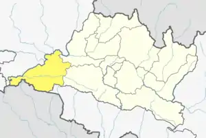
Kalika Municipality
कालिका | |
|---|---|
 Kalika Municipality Location in Nepal | |
| Coordinates: 27°42′N 84°31′E / 27.70°N 84.52°E | |
| Country | |
| Province | Bagmati Province |
| District | Chitwan District |
| Population (1991) | |
| • Total | 8,762 |
| Time zone | UTC+5:45 (Nepal Time) |
Jutpani is a village development committee in Chitwan District in Bagmati Province of southern Nepal. At the time of the 1991 Nepal census it had a population of 8,762 people living in 1,714 individual households.[1]
Geography
- East: Pithuwa VDC and Shaktikhor VDC
- West: Bharatpur Municipality
- North: Padampur VDC
- South: Ratnanagar Municipality
Education
- Private schools
- New Sagarmatha Secondary School, Jutpani-3 (Jutpani Bazzar)
- Moon Light Boarding School, Jutpani-1(Shanti Chowk)
- Siddhi Vinayak Boarding School Jutpani-1 (Kholesimal Bazzar)
- Janapriya Lower Secondary School, Jutpani-4
- State schools
- Prithivi Higher Secondary School Jutpani-4
- Jamunapur Ka Lower Secondary School, Jutpani-5
- Sivalaya Primary School, Jutpani-4
- Redcross Primary School, Jutpani-4
- Rastriya Primary School, Jutpani-3 (Jutpani Bazzar)
Major places
- Gaidakhola Tole
- Jutpani Bazzar
- Kholesimal Bazzar
- Kalika Temple
- Shanti Nikunja
- Sivalaya Temple, Gurauchour
- Jamunapur
- Bhateni/Prithivi Chowk
- Padampur
References
- ↑ "Nepal Census 2001". Nepal's Village Development Committees. Digital Himalaya. Archived from the original on October 12, 2008. Retrieved 12 December 2008.
This article is issued from Wikipedia. The text is licensed under Creative Commons - Attribution - Sharealike. Additional terms may apply for the media files.
