| Sly Creek Dam | |
|---|---|
 Sly Creek Reservoir | |
| Location | Butte County, California |
| Coordinates | 39°34′59″N 121°06′51″W / 39.58307°N 121.11420°W |
| Opening date | 1961 |
| Dam and spillways | |
| Impounds | Lost Creek |
| Height | 289 ft (88 m) |
| Length | 1,235 ft (376 m) |
| Reservoir | |
| Creates | Sly Creek Reservoir |
| Total capacity | 65,000 acre⋅ft (80,000,000 m3) |
| Surface area | 562 acres (227 ha) |
Sly Creek Dam (National ID # CA00272) is a dam in Butte County, California.
The earthen rockfill dam was completed in 1961 by the local public utility, the South Feather Water and Power Agency, formerly known as the Oroville-Wyandotte Irrigation District.[1] The dam stands 289 feet (88 m) high and 1,235 feet (376 m) long at its crest.[2] It impounds Lost Creek for irrigation storage and hydroelectric power, along with the smaller Lost Creek Dam immediately downstream.
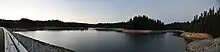
The reservoir it creates, Sly Creek Reservoir, has a water surface of 562 acres (227 ha) and a maximum capacity of 65,000 acre-feet (80,000,000 m3).[2] Recreation includes fishing, camping and hiking.[3] The site is surrounded by the Plumas National Forest.
See also
References
- ↑ http://southfeather.com/assets/2012/02/20111115_Packet.pdf
- 1 2 "Sly Creek". Archived from the original on 2012-10-12. Retrieved 2012-08-24.
- ↑ "Plumas National Forest - Sly Creek Recreation Area". Fs.usda.gov. Retrieved 2022-09-17.
This article is issued from Wikipedia. The text is licensed under Creative Commons - Attribution - Sharealike. Additional terms may apply for the media files.