Sodankylä
| |
|---|---|
Municipality | |
| Sodankylän kunta Soađegili gielda Sodankylä kommun | |
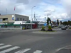
 Centre of Sodankylä | |
 Coat of arms | |
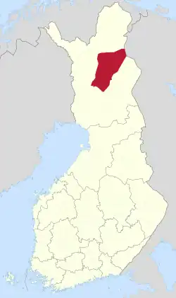
 Location of Sodankylä in Finland | |
| Coordinates: 67°25′N 026°35′E / 67.417°N 26.583°E | |
| Country | |
| Region | Lapland |
| Sub-region | Northern Lapland |
| Charter | 1893 |
| Government | |
| • Municipal manager | Jari Rantapelkonen[1] |
| Area (2018-01-01)[2] | |
| • Total | 12,415.50 km2 (4,793.65 sq mi) |
| • Land | 11,692.98 km2 (4,514.68 sq mi) |
| • Water | 718.65 km2 (277.47 sq mi) |
| • Rank | 2nd largest in Finland |
| Population (2023-09-30)[3] | |
| • Total | 8,137 |
| • Rank | 118th largest in Finland |
| • Density | 0.7/km2 (2/sq mi) |
| Population by native language | |
| • Finnish | 96.2% (official) |
| • Swedish | 0.2% |
| • Sami | 1.6% |
| • Others | 2% |
| Population by age | |
| • 0 to 14 | 13.3% |
| • 15 to 64 | 58.5% |
| • 65 or older | 28.2% |
| Time zone | UTC+02:00 (EET) |
| • Summer (DST) | UTC+03:00 (EEST) |
| Website | www |
Sodankylä (Finnish: [ˈsodɑŋˌkylæ]; Northern Sami: Soađegilli [ˈsoɑ̯ðeˌkilliː]; Inari Sami: Suáđigil; Skolt Sami: Suäʹđjel) is a municipality of Finland. It is located in the region of Lapland, and lies at the northern end of Highway 5 (E63) and along Highway 4 (E75). The Kitinen River flows near the center of Sodankylä. Its neighbouring municipalities are Inari, Kemijärvi, Kittilä, Pelkosenniemi, Rovaniemi, and Savukoski. The municipality has two official languages: Finnish and Northern Sami.
The municipality has a population of 8,137, (30 September 2023)[3] which makes it the fourth largest municipality in Lapland after Rovaniemi, Tornio and Kemi, and at the same time the largest municipality in population that does not use the title of city or town. It covers an area of 12,415.50 square kilometres (4,793.65 sq mi) of which 718.65 km2 (277.47 sq mi) is water,[2] making it the second largest municipality in Finland in terms of area, right after its neighboring municipality of Inari. The population density is 0.7 inhabitants per square kilometre (1.8/sq mi).
Sodankylä has an airfield. Also, one of EISCAT's scientific radar receiver stations is located outside Sodankylä, at the site of the Sodankylä Geophysical Observatory. The urban area around the observatory is known as "Tähtelä", which translates as "Place of Stars", although the observatory does not observe stars. The Jaeger Brigade of the Finnish Army is also located in Sodankylä.[6] There is also quite a lot of mining in Sodankylä, as the Pahtavaara mine (Pahtavaaran kaivos), which was opened in 1996 and focused on gold, and the Kevitsa mine (Kevitsan kaivos), which started commercial nickel mining production in 2012, operates in the municipality's territory.[7][8] Although the name "Sodankylä" and (also "Soađegilli") directly translate to "Village of War", the etymology of the name is from a surname Sova rather than the word "war".[9]
Since 1986, Sodankylä has been home to the Midnight Sun Film Festival (Sodankylän elokuvajuhlat).
Key sights, events and destinations
- Sodankylä Local History Museum
- The Old Church (made 1689 of wood), The New Church (made 1859 of stone)
- Tankavaara, gold museum, gold village
- Ilmakkiaapa peatland protection area (35 km north)
- Urho Kekkonen National Park (Koilliskaira Visitor Centre)
- Luosto – a hill home to the only open amethyst mine in Europe
- Hotel Sodankylä[10] and Hotel Bear Inn (Hotelli Karhu)[11]
- Midnight Sun Film Festival (annually mid-June)
- Museum-Gallery Alariesto (Andreas Alariesto's life and artwork)
- Pappilanniemi walking trail
- Igloo village of Kakslauttanen
The old church

The old church is one of the oldest churches in Lapland. The church was built in 1689 for the people of Middle Lapland. It was restored in 1926, and the shingles and the boarding were re-done between 1991 and 1995 by the National Board of Antiquities and Historical Monuments. The church is still open at summer time.
The statue "A reindeer and a Lapp"
Sculptor Ensio Seppänen designed this statue in 1970, located in the center of Sodankylä. The bronze statue presents reindeer husbandry, which still is one of the most important trades in Sodankylä.
Tankavaara Gold Museum
The International Gold Museum of Tankavaara presents the history of Finnish gold, as well as the history of the world's major gold rushes. A display called Golden world, tells the story of gold in more than 20 countries. The outdoor museum is housed within several historic buildings and the courtyard is decorated with a large bronze statue of a gold prospector, by the artist professor Ensio Seppänen. The museum's stone and mineral collection has more than 2500 samples on display from around the world.
Museum-gallery Alariesto
Andreas Alariesto (1900-1986) was a painter from Sodankylä.
Museum-Gallery Alariesto was opened in July 1986. The museum's permanent exhibition displays artist Andreas Alariesto's life and works. Museum-Gallery is maintenanted by Riikkas and Andreas Alariesto's Lapinkuvat (pictures of Lapland) Foundation and the Municipality of Sodankylä. The foundations's main goal is to take care of Alariesto's collected works and to preserve old Sompio's distinctive cultural tradition.
Geography
Sodankylä lies just north of the Arctic Circle.
Climate
Sodankylä has a subarctic climate (Koppen: Dfc), with short, mild summers and long, freezing, extremely snowy winters. However global warming has brought more extreme snowfalls, typically an increase. Its extreme northerly location combined with frequent overcast skies leads to very low amounts of sunshine in the winter months; December will average just under two minutes of sunshine daily. Sodankylä experiences polar night between 20 and 23 December and polar day between 31 May and 14 July.[12] The temperature is usually between −19.6 °C (−3.3 °F) and 19.4 °C (66.9 °F), but the all-time temperature range is between −49.5 °C (−57.1 °F) recorded on 28 January 1999 and 32.1 °C (89.8 °F) recorded on 18 July 2018.
| Climate data for Sodankylä Tähtelä, elevation: 179 metres or 587 feet, 1991-2020 normals, extremes 1908-present | |||||||||||||
|---|---|---|---|---|---|---|---|---|---|---|---|---|---|
| Month | Jan | Feb | Mar | Apr | May | Jun | Jul | Aug | Sep | Oct | Nov | Dec | Year |
| Record high °C (°F) | 6.5 (43.7) |
6.5 (43.7) |
11.1 (52.0) |
17.4 (63.3) |
28.1 (82.6) |
31.3 (88.3) |
32.1 (89.8) |
31.2 (88.2) |
24.0 (75.2) |
14.5 (58.1) |
9.2 (48.6) |
6.7 (44.1) |
32.1 (89.8) |
| Mean daily maximum °C (°F) | −8.1 (17.4) |
−7.6 (18.3) |
−1.8 (28.8) |
4.0 (39.2) |
10.5 (50.9) |
16.9 (62.4) |
20.2 (68.4) |
17.4 (63.3) |
11.1 (52.0) |
2.9 (37.2) |
−2.8 (27.0) |
−5.7 (21.7) |
4.8 (40.6) |
| Daily mean °C (°F) | −12.5 (9.5) |
−12.1 (10.2) |
−7.1 (19.2) |
−0.8 (30.6) |
5.6 (42.1) |
11.9 (53.4) |
15.0 (59.0) |
12.4 (54.3) |
7.0 (44.6) |
0.0 (32.0) |
−5.8 (21.6) |
−9.6 (14.7) |
0.3 (32.6) |
| Mean daily minimum °C (°F) | −17.5 (0.5) |
−17.2 (1.0) |
−12.9 (8.8) |
−6.0 (21.2) |
0.7 (33.3) |
6.9 (44.4) |
10.1 (50.2) |
7.8 (46.0) |
3.3 (37.9) |
−2.8 (27.0) |
−9.2 (15.4) |
−14.0 (6.8) |
−4.2 (24.4) |
| Record low °C (°F) | −49.5 (−57.1) |
−49 (−56) |
−42.7 (−44.9) |
−36 (−33) |
−21.3 (−6.3) |
−5.0 (23.0) |
−3.4 (25.9) |
−5.5 (22.1) |
−17 (1) |
−31.8 (−25.2) |
−42 (−44) |
−46.9 (−52.4) |
−49.5 (−57.1) |
| Average precipitation mm (inches) | 36 (1.4) |
31 (1.2) |
30 (1.2) |
32 (1.3) |
40 (1.6) |
61 (2.4) |
76 (3.0) |
56 (2.2) |
52 (2.0) |
47 (1.9) |
42 (1.7) |
41 (1.6) |
544 (21.5) |
| Mean monthly sunshine hours | 12 | 59 | 141 | 187 | 224 | 245 | 251 | 174 | 107 | 57 | 17 | 1 | 1,486 |
| Source 1: FMI climatological normals for Finland 1991-2020[13] | |||||||||||||
| Source 2: record highs and lows[14] | |||||||||||||
| Climate data for Sodankylä Vuotso (1991-2020 normals, extremes 1959-present) | |||||||||||||
|---|---|---|---|---|---|---|---|---|---|---|---|---|---|
| Month | Jan | Feb | Mar | Apr | May | Jun | Jul | Aug | Sep | Oct | Nov | Dec | Year |
| Record high °C (°F) | 6.0 (42.8) |
6.1 (43.0) |
9.5 (49.1) |
14.8 (58.6) |
26.9 (80.4) |
30.6 (87.1) |
31.7 (89.1) |
30.8 (87.4) |
22.3 (72.1) |
12.2 (54.0) |
8.2 (46.8) |
5.7 (42.3) |
31.7 (89.1) |
| Mean daily maximum °C (°F) | −8.8 (16.2) |
−8.5 (16.7) |
−3.0 (26.6) |
2.7 (36.9) |
8.8 (47.8) |
15.6 (60.1) |
19.1 (66.4) |
16.1 (61.0) |
10.0 (50.0) |
1.9 (35.4) |
−4.0 (24.8) |
−6.3 (20.7) |
3.6 (38.5) |
| Daily mean °C (°F) | −13.2 (8.2) |
−13 (9) |
−8.2 (17.2) |
−2.0 (28.4) |
4.2 (39.6) |
10.6 (51.1) |
13.9 (57.0) |
11.3 (52.3) |
6.1 (43.0) |
−0.9 (30.4) |
−6.9 (19.6) |
−10.5 (13.1) |
−0.7 (30.7) |
| Mean daily minimum °C (°F) | −18.3 (−0.9) |
−18.2 (−0.8) |
−14.3 (6.3) |
−7.3 (18.9) |
−0.4 (31.3) |
5.6 (42.1) |
8.8 (47.8) |
6.6 (43.9) |
2.1 (35.8) |
−3.9 (25.0) |
−11.2 (11.8) |
−15.0 (5.0) |
−5.5 (22.1) |
| Record low °C (°F) | −49 (−56) |
−47.1 (−52.8) |
−41.7 (−43.1) |
−32.7 (−26.9) |
−22.7 (−8.9) |
−4.9 (23.2) |
−3.3 (26.1) |
−7.3 (18.9) |
−18.7 (−1.7) |
−29.3 (−20.7) |
−36.1 (−33.0) |
−40.3 (−40.5) |
−49 (−56) |
| Source 1: https://www.ilmatieteenlaitos.fi/ilmastollinen-vertailukausi | |||||||||||||
| Source 2: https://kilotavu.com/asema-taulukko.php?asema=102001 | |||||||||||||
Twin towns
Gallery
 Sodankylä New Church
 Tankavaara's gold prospecting stream
 Igloo village of Kakslauttanen
 The Kitinen River in Sodankylä
Notable people
- Andreas Alariesto (1900–1989), painter
- Benjamin Anneberg (1865–1925), lawyer and politician
- Aleksi Hihnavaara (1882–1938), frontiersman and reindeer herder
- Kaija Kärkinen (born 1962), singer and actress
- Maria Lähteenmäki (born 1957), history researcher and university professor
- Lasse Näsi (1930–2022), politician
- Katja Riipi (born 1975), retired ice hockey player
- Johanna Sinisalo (born 1958), science fiction and fantasy writer
- Pertti Ukkola (born 1950), wrestler and Olympic champion
See also
References
- ↑ "Kirsi Virtanen Sodankylän kunnanjohtajaksi". Yle Uutiset (in Finnish). Retrieved 28 October 2020.
- 1 2 "Area of Finnish Municipalities 1.1.2018" (PDF). National Land Survey of Finland. Retrieved 30 January 2018.
- 1 2 "Preliminary population statistics 2023, September". StatFin. Statistics Finland. Retrieved 26 October 2023.
- ↑ "Demographic Structure by area as of 31 December 2022". Statistics Finland's PX-Web databases. Statistics Finland. Retrieved 6 September 2023.
- ↑ "Population according to age (1-year) and sex by area and the regional division of each statistical reference year, 2003–2020". StatFin. Statistics Finland. Retrieved 2 May 2021.
- ↑ "The Jaeger Brigade". Business Lapland. Retrieved 2023-04-05.
- ↑ "Pahtavaara: Mineral Deposit Report" (PDF). Geological Survey of Finland. 2022. Retrieved 2023-04-05.
- ↑ "Reserves & Resources". first-quantum.com. 2013. Archived from the original on 2013-06-22. Retrieved 2013-06-21.
- ↑ "Lapin pitäjien nimiä - Kielikello". Kielikello (in Finnish). Retrieved 2021-02-18.
- ↑ Hotel Sodankylä
- ↑ Hotelli Karhu
- ↑ "Sunrise and sunset times in Sodankylä, July 2015".
- ↑ "FMI normals 1991-2020". fmi.fi. Retrieved 13 February 2023.
- ↑ "FMI data". FMI. Retrieved 19 November 2020.

